Siret River
| Siret | |
 | |
| Countries | Ukraine, Romania |
|---|---|
| Counties/ Oblasts |
Ukraine: Chernivtsi O. Romania: Botoşani C., Suceava C., |
| Tributaries | |
| - left | Bârlad |
| - right | Suceava, Moldova, Bistriţa, Trotuş, Putna, Buzău |
| Cities | Roman, Bacău, Galaţi |
| Source | |
| - location | Eastern Carpathians, Chernivtsi O., Ukraine |
| - elevation | 1,238 m (4,062 ft) |
| Mouth | Danube |
| - location | Galaţi |
| - coordinates | 45°24′11″N 28°1′27″E / 45.40306°N 28.02417°E |
| Length | 706 km (439 mi) |
| Basin | 44,835 km2 (17,311 sq mi) |
| Discharge | |
| - average | 220 m3/s (7,769 cu ft/s) |
| Official River Code | XII.1 |
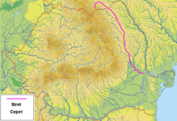
 The Siret in Romania and Ukraine
| |
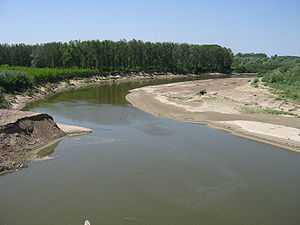
The Siret or Sireth (Ukrainian: Сірет or Серет, Romanian: Siret pronounced [siˈret], Hungarian: Szeret, Russian: Сирет) is a river that rises from the Carpathians in the Northern Bukovina region of Ukraine, and flows southward into Romania for 470 km before it joins the Danube. In ancient times, it was named Hierasus (Ancient Greek Ιερασός).
Towns and villages
The following towns and villages are situated along the river Siret, from source to mouth: Berehomet, Storozhynets, Siret, Grămești, Zvoriștea, Liteni, Dolhasca, Paşcani, Stolniceni-Prăjescu, Roman, Bacău, Adjud, Mărășești, Galaţi.
Tributaries

The following rivers are tributaries to the river Siret:
Left: Bahna, Molniţa, Bahna, Gârla Sirețel, Gârla Huțanilor, Vorona, Pleşu, Turbata, Pitrosul, Trestioara, Sireţel, Sodomeni, Stolniceni, Hărmăneşti, Pârâul Țigăncilor, Mihailei, Boca, Albuia, Vulpăşeşti, Ţiganca, Icuşeşti, Glodeni, Râpaş, Pârâul Morii, Răcătău, Fulgeriş, Polocin, Lupa, Bârlad, Călmăţui, Gerului, Mălina, Fălcoaia, Cătuşa
Right: Găvan, Negostina, Verehia, Baranca, Leahu, Hănţeşti, Grigoreşti, Sălăgeni, Suceava, Şomuzul Mic, Şomuzul Mare, Probota, Conţeasca, Ruja, Valea Părului, Podul Turcului, Tămăşeni, Moldova, Valea Neagră, Turbata, Bistriţa, Cleja, Răcăciuni, Orbeni, Botohan, Fântânele, Conţeşti, Trotuş, Valea Boului, Carecna, Zăbrăuţi, Şuşiţa, Gârla Morilor, Putna, Leica, Râmnicul Sărat, Buzău
2010 floodings
During July 2010, Gheorghe Flutur, president of Suceava judet, told the Mediafax news agency his region was one of the worst hit in the country in the morning of the 29th as he co-ordinated local flood relief work in his stricken county.[1] Later that day the River Siret threatened to break through the dykes protecting the town of Șendreni, as locals and emergency services reinforced the dykes with truckloads of sandbags to prevent the river breaking out and flooding the town.[1]
See also
References
External links
| Wikimedia Commons has media related to Siret River. |
- Administrația Națională Apelor Române - Cadastrul Apelor - București
- Institutul de Meteorologie și Hidrologie - Rîurile României - București 1971
