Sinzing
| Sinzing | ||
|---|---|---|
| ||
 Sinzing | ||
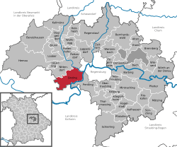
Location of Sinzing within Regensburg district  | ||
| Coordinates: 48°59′28″N 12°02′05″E / 48.99111°N 12.03472°ECoordinates: 48°59′28″N 12°02′05″E / 48.99111°N 12.03472°E | ||
| Country | Germany | |
| State | Bavaria | |
| Admin. region | Oberpfalz | |
| District | Regensburg | |
| Subdivisions | 24 Ortsteile | |
| Government | ||
| • Mayor | Patrick Grossmann (CSU) | |
| Area | ||
| • Total | 44.30 km2 (17.10 sq mi) | |
| Elevation | 338 m (1,109 ft) | |
| Population (2012-12-31)[1] | ||
| • Total | 6,790 | |
| • Density | 150/km2 (400/sq mi) | |
| Time zone | CET/CEST (UTC+1/+2) | |
| Postal codes | 93161 | |
| Dialling codes | 0941, 09404 | |
| Vehicle registration | R | |
| Website | www.sinzing.de | |
Sinzing is a municipality in the district of Regensburg in Bavaria in Germany.
History
Sinzing first appears in historical records in 921. In 1031 the part known as Eilsbrunn was mentioned. This was, however almost completely destroyed during the Thirty Years' War. Also destroyed were the fortifications in Niederviehhausen, of which one can now only see the tower. From 1145 until 1966 it was possible to cross the Danube at Sinzing and until 1485, it was a part of the trade route between Regensburg and Nürnberg. Up until the 17th century wine was cultivated in Sinzing. In the 19th century there were many mills, some paper factories and a tobacco factory in Sinzing.
The modern district was created in 1972 by the incorporation of the districts of Sinzing, Viehhausen, Eilsbrunn and Bergmatting, which until that point had been independent.
References
- ↑ "Fortschreibung des Bevölkerungsstandes". Bayerisches Landesamt für Statistik und Datenverarbeitung (in German). 31 December 2012.
