Sint-Katelijne-Waver
From Wikipedia, the free encyclopedia
| Sint-Katelijne-Waver | |||
|---|---|---|---|
| Municipality of Belgium | |||
| |||
 Sint-Katelijne-Waver | |||
|
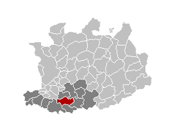
Map of Sint-Katelijne-Waver
| |||
| Coordinates: 51°04′N 04°32′E / 51.067°N 4.533°ECoordinates: 51°04′N 04°32′E / 51.067°N 4.533°E | |||
| Country | Belgium | ||
| Community | Flemish Community | ||
| Region | Flemish Region | ||
| Province | Antwerp | ||
| Arrondissement | Mechelen | ||
| Government | |||
| • Mayor | Kristof Sels (NVA) | ||
| • Governing party/ies | CD&V/N-VA, independent | ||
| Area | |||
| • Total | 36.12 km2 (13.95 sq mi) | ||
| Population (1 January 2012)[1] | |||
| • Total | 20,349 | ||
| • Density | 560/km2 (1,500/sq mi) | ||
| Postal codes | 2860, 2861 | ||
| Area codes | 015, 03 | ||
| Website | www.sint-katelijne-waver.be | ||
Sint-Katelijne-Waver (old spelling: Kathelijne-Waver, French Wavre-Sainte-Catherine) is a municipality located in the Belgian province of Antwerp. The municipality comprises the towns of Onze-Lieve-Vrouw-Waver and Sint-Katelijne-Waver proper. On January 1, 2006 Sint-Katelijne-Waver had a total population of 19,577. The total area is 36.12 km² which gives a population density of 542 inhabitants per km².
Economic activities
Sint-Katelijne-Waver is a centre for market gardening and hosts a lot of greenhouses. The Mechelse Veilingen in Sint-Katelijne-Waver is the largest co-operative vegetable auction in Europe.
Pictures
-

Leliestraat
-

town hall
-

church
-

centre
-

centre
Bekende inwoners
Publie Jasper Bart Cannaerts
References
- ↑ Population per municipality on 1 January 2012 (XLS; 214 KB)
External links
- Official website - Available only in Dutch
| |||||||||||||
This article is issued from Wikipedia. The text is available under the Creative Commons Attribution/Share Alike; additional terms may apply for the media files.


