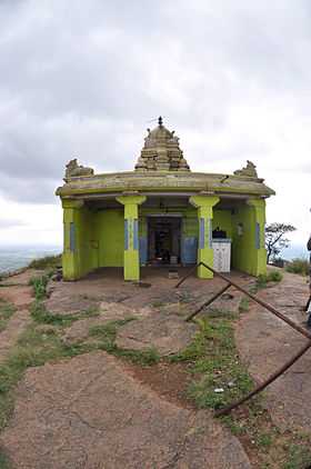
Shivagange
| Shivagange | |
|---|---|
| Shivaganga | |
 Shivaganga | |
| Location | |
 Shivaganga | |
| Coordinates | 13°10′5″N 77°13′20″E / 13.16806°N 77.22222°ECoordinates: 13°10′5″N 77°13′20″E / 13.16806°N 77.22222°E |
Shivagange [Kannada: ಶಿವಗಂಗಾ] is a mountain peak and Hindu pilgrimage near Dabaspet, in Bangalore Rural district India. It is situated 8 km from the town of Tumkur and 54 km from Bangalore. [1] The sacred mountain is shaped as a shivalingam and a spring flows near locally called "Ganga", thereby by giving the place its name. It is also known as Dakshina Kashi (Kashi of the South) and as various temples such as Gangadhareshwara temple, Olakal Teertha, Nandi Statue, Patalagange.[2] The area is also a popular site for rock climbing in the Karnataka state.[citation needed]
The entire trail to the peak is well marked and the presence of man-made steps (often carved into the rocky landscape, but sometimes made from rocks) makes the trail suitable for beginners. There are frequent rest opportunities with stalls serving food and drinks. The vertical ascent is approximately 800 metres, much of which is climbed towards the end of the path where the trail becomes steep and narrow - safety rails are provided in such areas.
Monkeys are a pest in the area, often snatching belongings (especially food) from unsuspecting trekkers.
In 2012, a Tamil inscription dating 1304 CE was found in Doddanekkundi village near Bangalore, mentioning that the Hoysala king, Vira Ballala, had granted the entire revenue collection of the village to the temple for its daily puja .[3]
Gallery
-
From Foot Hills
-
Basavanna
-
Olakal Theertha
-
Architecture
-
Shiva Parvathi
-
Architecture
-
Veerabhadra Swamy
-
Basavanna
-
Olakal Theertha
References
| Wikimedia Commons has media related to Shivagange. |
- ↑ Shivagange mustseeindia.com
- ↑ Shivagange
- ↑ "Of inscriptions and the medieval period: Tamil inscription". The Hindu. January 11, 2012.


