Shire of Dowerin
From Wikipedia, the free encyclopedia
| Shire of Dowerin Western Australia | |||||||||||||
|---|---|---|---|---|---|---|---|---|---|---|---|---|---|
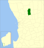 Location in Western Australia | |||||||||||||
| Population | 752 (2011 est)[1] | ||||||||||||
| • Density | 0.40721/km2 (1.0547/sq mi) | ||||||||||||
| Established | 1911 | ||||||||||||
| Area | 1,846.7 km2 (713.0 sq mi) | ||||||||||||
| Mayor | Dale Metcalf | ||||||||||||
| Council seat | Dowerin | ||||||||||||
| Region | Wheatbelt | ||||||||||||
| State electorate(s) | Central Wheatbelt | ||||||||||||
| Federal Division(s) | Durack | ||||||||||||
|
| |||||||||||||
| Website | www.dowerin.wa.gov.au | ||||||||||||
| |||||||||||||
The Shire of Dowerin is a local government area in the Wheatbelt region of Western Australia, about 160 kilometres (99 mi) northeast of Perth, the state capital. The Shire covers an area of 1,847 square kilometres (713 sq mi) and its seat of government is the town of Dowerin.
History
On 3 November 1911, the Dowerin Road District was gazetted. On 1 July 1961, it became a shire following enactment of the Local Government Act 1960.[2]
Wards
From 3 May 2003 the Shire has been divided into 3 wards.
- Town Ward (4 councillors)
- Rural North Ward (2 councillors)
- Rural South Ward (2 councillors)
Previously, Town Ward had 2 councillors and six wards had one councillor each: Daren, Hindmarsh, Koombekine, Manmanning, Minnivale and Ucarty.[2]
Towns and localities
- Dowerin
- Amery
- Ejanding
- Koomberkine
- Manmanning
- Minnivale
- Ucarty
Population
| Year | Population |
|---|---|
| 1921 | 1,063 |
| 1933 | 1,475 |
| 1947 | 1,152 |
| 1954 | 1,311 |
| 1961 | 1,392 |
| 1966 | 1,300 |
| 1971 | 1,071 |
| 1976 | 1,070 |
| 1981 | 998 |
| 1986 | 961 |
| 1991 | 881 |
| 1996 | 817 |
| 2001 | 782 |
| 2006 | 702 |
References
- ↑ "3218.0 Regional Population Growth, Australia. Table 5. Estimated Resident Population, Local Government Areas, Western Australia". 30 March 2012. Retrieved 26 May 2012.
- ↑ 2.0 2.1 WA Electoral Commission, Municipality Boundary Amendments Register (release 3.0), 31 July 2007.
External links
| ||||||||||||||||||||||||||||||||||||||||||||||
Coordinates: 31°11′31″S 117°02′02″E / 31.192°S 117.034°E
This article is issued from Wikipedia. The text is available under the Creative Commons Attribution/Share Alike; additional terms may apply for the media files.