Shire of Blackall
| Shire of Blackall Queensland | |||||||||||||
|---|---|---|---|---|---|---|---|---|---|---|---|---|---|
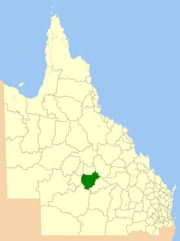
 Location within Queensland | |||||||||||||
| Population | 1,524 (2006 census)[1] | ||||||||||||
| • Density | 0.093115/km2 (0.24117/sq mi) | ||||||||||||
| Established | 1879 | ||||||||||||
| Area | 16,366.8 km2 (6,319.3 sq mi) | ||||||||||||
| Council seat | Blackall | ||||||||||||
 | |||||||||||||
The Shire of Blackall was a local government area located in central Queensland around the town of Blackall. It covered an area of 16,366.8 square kilometres (6,319.3 sq mi), and existed as a local government entity from 1879 until 2008, when it amalgamated with neighbouring Shire of Tambo to form the Blackall-Tambo Region.
The council consisted of a Mayor and 9 elected councillors. No wards or electoral divisions existed.
The Barcoo River passes through the shire's former area and the dominant industry is sheep and cattle grazing.
History

Kargoolnah Division was created on 11 November 1879 as one of 74 divisions around Queensland under the Divisional Boards Act 1879 with a population of 726.[2] The division included the areas of Blackall, Tambo and Barcaldine and parts of Jericho (these areas are now part of the Barcaldine Region). Its headquarters were in Blackall.[3]
On 20 May 1880, the urban part of Blackall was excised from the Kargoolnah Division to create a municipal Borough of Blackall[4] and its first councillors were elected in July 1880.
With the passage of the Local Authorities Act 1902, Kargoolnah Division became the Shire of Kargoolnah on 31 March 1903, while the Borough of Blackall became the Town of Blackall. The town was abolished on 7 November 1931 and became Division 3 of the Shire of Kargoolnah, which had in the meantime shrunk to include only the Blackall region. On 19 November 1932, after representations to the State Government, the Shire of Kargoolnah was officially renamed Shire of Blackall.[5]
On 15 March 2008, under the Local Government (Reform Implementation) Act 2007 passed by the Parliament of Queensland on 10 August 2007, the Shire of Blackall merged with the Shire of Tambo to form the Blackall-Tambo Region.
Towns and localities
Population
| Year | Population |
|---|---|
| 1933 | 2,755 |
| 1947 | 2,488 |
| 1954 | 2,780 |
| 1961 | 3,291 |
| 1966 | 3,067 |
| 1971 | 2,325 |
| 1976 | 2,160 |
| 1981 | 2,223 |
| 1986 | 2,070 |
| 1991 | 2,045 |
| 1996 | 1,833 |
| 2001 | 1,822 |
| 2006 | 1,524 |
Chairmen
- 1891: A. Parnell[6]
References
- ↑ Australian Bureau of Statistics (25 October 2007). "Blackall (S) (Local Government Area)". 2006 Census QuickStats. Retrieved 17 September 2009.
- ↑ "Proclamation [Kargoolnah Division]". Queensland Government Gazette. 11 November 1879. p. 25:1005.
- ↑ "Kargoolnah Divisional Board.". The Western Champion (Blackall/Barcaldine, Qld. : 1879 - 1891) (Blackall/Barcaldine, Qld.: National Library of Australia). 14 April 1880. p. 3. Retrieved 26 September 2013.
- ↑ "Blackall Municipality". Queensland Government Gazette. 22 May 1880. p. 26:1144.
- ↑ "Order in Council". Queensland Government Gazette. 19 November 1932. p. 139:1594.
- ↑ Consolidated Index to Queensland Government Gazette 1859-1919. Queensland Family History Society. 2004. ISBN 1 876613 79 3.
| ||||||||||||||||||||
Coordinates: 24°35′35″S 145°26′28″E / 24.593°S 145.441°E