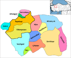
Seyitgazi is a town and district of Eskişehir Province in the Central Anatolia region of Turkey. The central town of Seyitgazi lies at a distance of 43 km (27 mi) towards the south from the province capital of Eskişehir. According to 2010 census, population of the district is 16,222 of which 2,890 live in the town of Seyitgazi.[3][4] The district covers an area of 1,502 km2 (580 sq mi), and the average elevation is 1,040 m (3,412 ft).
Apart from the center town of Seyitgazi, the district has two depending townships with own municipalities. These are Kırka and Doğançayır. The district also counts 46 villages.[5]
Places of interest
The town occupies the site of the Byzantine city of Nakoleia, and was named after the 8th-century Muslim saint and warrior Battal Gazi who fell in a battle nearby in 740. A külliye dedicated to Battal Gazi and containing his tomb, a mosque, a medrese, cells and ceremonial rooms for dervishes as well as benevolent services for the community such as kitchens and a bakery was built in 1208 on a hill overlooking the town by Ümmühan Hatun, wife of the Anatolian Seljuk sultan Gıyaseddin Keyhüsrev I and further extended in 1511 by the Ottoman sultan Bayezid II. The shrine and the adjoining complex remains much visited by visitors from across Turkey as well as by international visitors.
Notes
References
External links
|
|---|
| | Central district(s) | | |
|---|
| | Other districts | |
|---|
|
| | | Istanbul | |
|---|
| | Western Marmara | |
|---|
| | Aegean | |
|---|
| | Eastern Marmara | |
|---|
| | Western Anatolia | |
|---|
| | Mediterranean | |
|---|
| | Central Anatolia | |
|---|
| | Western Black Sea | |
|---|
| | Eastern Black Sea | |
|---|
| | North Eastern Anatolia | |
|---|
| | Central Eastern Anatolia | |
|---|
| | South Eastern Anatolia | |
|---|
| | |
|

