Searchlight, Nevada
| Searchlight, Nevada | |
|---|---|
| Unincorporated town | |
 | |
 | |
 | |
| Coordinates: 35°28′6″N 114°55′1″W / 35.46833°N 114.91694°W | |
| Country | United States |
| State | Nevada |
| Area | |
| • Total | 13.1 sq mi (33.9 km2) |
| • Land | 13.1 sq mi (33.9 km2) |
| • Water | 0.0 sq mi (0.0 km2) |
| Elevation | 3,547 ft (1,081 m) |
| Population (2010) | |
| • Total | 539 |
| • Density | 41/sq mi (16/km2) |
| Time zone | PST (UTC-8) |
| • Summer (DST) | PDT (UTC-7) |
| ZIP codes | 89039, 89046 |
| Area code(s) | 702 |
| FIPS code | 32-65600 |
| GNIS feature ID | 0845654 |
| Website | Searchlight Town Advisory Board |
|
Nevada Historical Marker | |
| Reference No. | 116 |
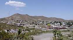
Searchlight is a census-designated place (CDP) and unincorporated town in Clark County, Nevada, United States, at the topographic saddle between two mountain ranges. As of the 2010 census it had a population of 539.[1]
History
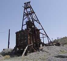
According to Nevada Senator Harry Reid, who has written extensively about his hometown, the most likely story as to how the town received its name was that when George Frederick Colton was looking for gold in the area in 1897, he supposedly said that it would take a searchlight to find gold ore there.[citation needed] Shortly thereafter he found gold, leading to a boom era when Searchlight had a larger population than Las Vegas. At the time, it was in Lincoln County, Nevada. As talk surfaced for carving Clark County, Nevada out of Lincoln County, Searchlight was initially considered to be the county seat.[citation needed] Between 1907 and 1910 the gold mines produced $7 million in gold and other precious minerals, and the town had a population of about 1,500.
Other stories on the origin of the name include a story that Colton was lighting a Searchlight brand match when he discovered the gold ore. Reid dismisses this story, saying that the Searchlight matches were not available in 1898. Yet another story says that Colton thought the area would be a good place because it was on a hill. Colton's mine was called the Duplex, because the gold ore was found on two levels.[2][3]
Searchlight declined after 1917 but hung on as a stop on the Arrowhead Highway. In 1927, U.S. Highway 91 bypassed the town, and its population dropped to 50.
The town had a resurgence in the 1930s and 1940s with the construction of nearby Hoover Dam and was home to the El Rey Bordello in the 1940s and early 1950s until it burned. The last gold mine ceased operating around 1953.
Climate
Searchlight experiences a desert climate with hot summers and cool winters. Searchlight's elevation makes temperatures somewhat cooler then lower-elevation areas in the Mojave Desert, such as Baker, California, and Needles, California, and Fort Mohave, Arizona. However, summers can still be extremely hot. Due to Searchlight's altitude and aridity, temperatures drop quickly after sunset, especially in the summer. Winters are mild. Daytime highs in the winter are usually well above freezing, and nighttime lows drop below freezing only a few nights a year.
| Climate data for Searchlight, Nevada. (Elevation 3,550 ft) | |||||||||||||
|---|---|---|---|---|---|---|---|---|---|---|---|---|---|
| Month | Jan | Feb | Mar | Apr | May | Jun | Jul | Aug | Sep | Oct | Nov | Dec | Year |
| Record high °F (°C) | 77 (25) |
81 (27) |
90 (32) |
94 (34) |
102 (39) |
110 (43) |
111 (44) |
110 (43) |
107 (42) |
98 (37) |
86 (30) |
75 (24) |
111 (44) |
| Average high °F (°C) | 53.7 (12.1) |
58.4 (14.7) |
65.0 (18.3) |
73.1 (22.8) |
82.5 (28.1) |
92.7 (33.7) |
97.6 (36.4) |
95.4 (35.2) |
89.0 (31.7) |
77.0 (25) |
63.6 (17.6) |
54.4 (12.4) |
75.2 (24) |
| Average low °F (°C) | 35.6 (2) |
38.3 (3.5) |
41.8 (5.4) |
48.0 (8.9) |
55.9 (13.3) |
64.8 (18.2) |
71.4 (21.9) |
69.6 (20.9) |
63.9 (17.7) |
53.9 (12.2) |
43.0 (6.1) |
36.4 (2.4) |
51.9 (11.1) |
| Record low °F (°C) | 7 (−14) |
11 (−12) |
20 (−7) |
27 (−3) |
30 (−1) |
40 (4) |
52 (11) |
51 (11) |
41 (5) |
23 (−5) |
15 (−9) |
8 (−13) |
7 (−14) |
| Precipitation inches (mm) | 0.92 (23.4) |
0.96 (24.4) |
0.77 (19.6) |
0.40 (10.2) |
0.20 (5.1) |
0.11 (2.8) |
0.91 (23.1) |
1.08 (27.4) |
0.61 (15.5) |
0.52 (13.2) |
0.43 (10.9) |
0.79 (20.1) |
7.70 (195.6) |
| Source: The Western Regional Climate Center[4] | |||||||||||||
Demographics

As of the census[5] of 2000, there were 576 people, 315 households, and 136 families residing in the CDP. The population density was 44.1 people per square mile (17.0/km²). There were 444 housing units at an average density of 34.0 per square mile (13.1/km²). The racial makeup of the CDP was 95.0% White, 0.7% African American, 0.7% Native American, 0.2% Asian, 0.2% Pacific Islander, 1.7% from other races, and 1.6% from two or more races. Hispanic or Latino of any race were 3.7% of the population.
There are 315 households out of which 8.6% had children under the age of 18 living with them, 34.9% were married couples living together, 5.1% had a female householder with no husband present, and 56.8% were non-families. 48.3% of all households were made up of individuals and 23.5% had someone living alone who was 65 years of age or older. The average household size was 1.76 and the average family size was 2.46.
In the CDP the population was spread out with 10.1% under the age of 18, 3.1% from 18 to 24, 20.0% from 25 to 44, 35.8% from 45 to 64, and 31.1% who were 65 years of age or older. The median age was 55 years. For every 100 females there were 125.9 males. For every 100 females age 18 and over, there were 131.3 males.
The median income for a household in the CDP was $24,407, and the median income for a family was $29,323. Males had a median income of $26,563 versus $27,868 for females. The per capita income for the CDP was $19,606. None of the household families were living below the poverty line, with just 14.6% of the population comprising that, including no one under age 18 and none of those over 64.
Education
Clark County School District operates the public schools. Reid Elementary School (K–5) serves Searchlight.[6]
Notable residents
- Rex Bell, westerns actor and politician. Owned the Walking Box Ranch with his wife Clara Bow. The ranch was a popular destination for Hollywood actors.
- Edith Head, costume designer who won more Oscars than any other woman[7]
- William Harrell Nellis, aviator for whom Nellis Air Force Base is named[8]
- Harry Reid, U.S. Senate Majority Leader[9]
In popular culture
In 1907, the "Searchlight Rag" by Scott Joplin was published. In the early 1890s, Joplin's friends, the brothers Tom and Charles Turpin, had done prospecting in the Searchlight area. The brothers' frequent stories of this experience, recounted to the patrons of their bar, inspired the title of the rag.[10]
See also
References
- ↑ "Profile of General Population and Housing Characteristics: 2010 Demographic Profile Data (DP-1): Searchlight CDP, Nevada". U.S. Census Bureau, American Factfinder. Retrieved March 13, 2012.
- ↑ Harry Colton - 1st100.com
- ↑ Searchlight: The Camp That Didn't Fail, by Harry Reid. University of Nevada Press (January 1998), ISBN 0-87417-310-8
- ↑ "Seasonal Temperature and Precipitation Information". Western Regional Climate Center. Retrieved March 24, 2013.
- ↑ "American FactFinder". United States Census Bureau. Retrieved 2008-01-31.
- ↑ "2008-09 Elementary School - Southeastern Attendance Boundaries". Clark County School District. Retrieved September 28, 2008.
- ↑ Van Atta, Burr. "OBITUARIES EDITH HEAD, MOST HONORED MOVIE COSTUME DESIGNER." Philadelphia Inquirer. October 27, 1981. Page D07.
- ↑ "Factsheets : Lieutenant William Harrell Nellis". Nellis.af.mil. Retrieved 2010-07-26.
- ↑ "REID, Harry - Biographical Information". Bioguide.congress.gov. Retrieved 2010-07-26.
- ↑ http://www.perfessorbill.com/pbmidi15a.shtml
External links
| ||||||||||||||||||||||||||
Coordinates: 35°28′6″N 114°55′1″W / 35.46833°N 114.91694°W
