Seßlach
| Seßlach | ||
|---|---|---|
 | ||
| ||
 Seßlach | ||
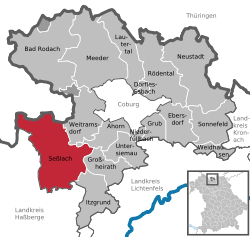
Location of Seßlach within Coburg district  | ||
| Coordinates: 50°10′N 10°50′E / 50.167°N 10.833°ECoordinates: 50°10′N 10°50′E / 50.167°N 10.833°E | ||
| Country | Germany | |
| State | Bavaria | |
| Admin. region | Oberfranken | |
| District | Coburg | |
| Subdivisions | 14 villages one town | |
| Government | ||
| • Mayor | Hendrik Dressel (FW) | |
| Area | ||
| • Total | 72.51 km2 (28.00 sq mi) | |
| Elevation | 271 m (889 ft) | |
| Population (2012-12-31)[1] | ||
| • Total | 3,962 | |
| • Density | 55/km2 (140/sq mi) | |
| Time zone | CET/CEST (UTC+1/+2) | |
| Postal codes | 96145 | |
| Dialling codes | 09569 | |
| Vehicle registration | CO | |
| Website | www.sesslach.de | |
Seßlach is a town in the district of Coburg, in northern Bavaria, Germany. It is situated 12 km southwest of Coburg.
Seßlach consists of 15 parts: (Inhabitants as of December 31, 2005)
|
|
|
History
After the disruption of the Thuringian Empire (531) the Grabfeldgau was populated by Frankish peasants. From the East Slavic (Wendish) settlers pressed forward into the region of Schweinfurt, who were on the run from their Avar enemies. In the 11th century numerous Slavs in Franconia were not yet Christianized. As fore-rectories of the Bishopric of Würzburg were (among others) Baunach, Pfarrweisach and Seßlach created. The patron saint of Seßlach, John the Baptist defers to the rectory's role as a base for the Slav mission. 1007 the Bishopric of Bamberg was founded.
The first written mention of the two settlements on the Kirchhügel (Church hill) and the Geiersberg (vulture mountain) comes from the year 800 AD. The Abbess Emhild of the monastery Milz transferred the monasterial properties by this certificate to the Abbey of Fulda.
| |||||||
References
- ↑ "Fortschreibung des Bevölkerungsstandes". Bayerisches Landesamt für Statistik und Datenverarbeitung (in German). 31 December 2012.
