Schlieben
From Wikipedia, the free encyclopedia
| Schlieben | ||
|---|---|---|
| ||
 Schlieben | ||
Location of Schlieben within Elbe-Elster district  | ||
| Coordinates: 51°43′00″N 13°22′59″E / 51.71667°N 13.38306°ECoordinates: 51°43′00″N 13°22′59″E / 51.71667°N 13.38306°E | ||
| Country | Germany | |
| State | Brandenburg | |
| District | Elbe-Elster | |
| Municipal assoc. | Schlieben | |
| Subdivisions | 6 Ortsteile | |
| Government | ||
| • Mayor | Helmut Richter (SPD) | |
| Area | ||
| • Total | 78.22 km2 (30.20 sq mi) | |
| Elevation | 89 m (292 ft) | |
| Population (2012-12-31)[1] | ||
| • Total | 2,588 | |
| • Density | 33/km2 (86/sq mi) | |
| Time zone | CET/CEST (UTC+1/+2) | |
| Postal codes | 04936 | |
| Dialling codes | 035361 | |
| Vehicle registration | EE | |
| Website | www.schlieben.com | |

Schlieben is a town in the Elbe-Elster district, in southwestern Brandenburg, Germany. It is situated 22 km north of Bad Liebenwerda. Schlieben was the site of a concentration camp during the Holocaust.
Demography
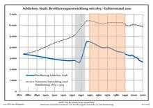
Development of Population since 1875 within the Current Boundaries (Blue Line: Population; Dotted Line: Comparison to Population Development of Brandenburg state; Grey Background: Time of Nazi rule; Red Background: Time of Communist rule)
|
|
|
|
Detailed data sources are to be found in the Wikimedia Commons.[3]
References
- ↑ "Bevölkerung im Land Brandenburg nach amtsfreien Gemeinden, Ämtern und Gemeinden 31. Dezember 2012 (XLS-Datei; 83 KB) (Einwohnerzahlen auf Grundlage des Zensus 2011)". Amt für Statistik Berlin-Brandenburg (in German). 31 December 2012.
- ↑ Boundaries as of 2013
- ↑ Population Projection Brandenburg at Wikimedia Commons
This article is issued from Wikipedia. The text is available under the Creative Commons Attribution/Share Alike; additional terms may apply for the media files.