Schipkau
| Schipkau | ||
|---|---|---|
| ||
 Schipkau | ||
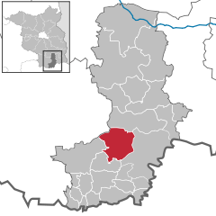
Location of Schipkau within Oberspreewald-Lausitz district 
 | ||
| Coordinates: 51°31′00″N 13°52′59″E / 51.51667°N 13.88306°ECoordinates: 51°31′00″N 13°52′59″E / 51.51667°N 13.88306°E | ||
| Country | Germany | |
| State | Brandenburg | |
| District | Oberspreewald-Lausitz | |
| Subdivisions | 6 Ortsteile | |
| Government | ||
| • Mayor | Siegurd Heinze | |
| Area | ||
| • Total | 72.91 km2 (28.15 sq mi) | |
| Elevation | 109 m (358 ft) | |
| Population (2012-12-31)[1] | ||
| • Total | 7,017 | |
| • Density | 96/km2 (250/sq mi) | |
| Time zone | CET/CEST (UTC+1/+2) | |
| Postal codes | 01993 | |
| Dialling codes | 035754 | |
| Vehicle registration | OSL | |
| Website | www.gemeinde-schipkau.de | |
Schipkau is a municipality in the Oberspreewald-Lausitz district, in southern Brandenburg, Germany.
Geography
The municipality is located in the north of the historical region of Lusatia, close to the motorway A13, connecting Berlin with Dresden.
Schipkau counts 5 civil parishes (Ortsteile): Annahütte, Drochow, Hörlitz, Klettwitz and Meuro.
Demography
-

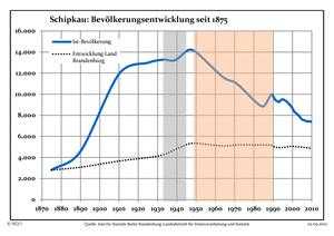
Development of Population since 1875 within the Actual Boundaries (Blue Line: Population; Dotted Line: Comparison to Population Development of Brandenburg state; Grey Background: Time of Nazi rule; Red Background: Time of Communist rule)
-

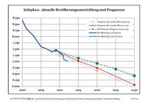
Recent Population Development (Blue Line) and Forecasts
Sport
Close to Klettwitz and in north of Schipkau it is located the "EuroSpeedway Lausitz", a race track originally named "Lausitzring".
References
- ↑ "Bevölkerung im Land Brandenburg nach amtsfreien Gemeinden, Ämtern und Gemeinden 31. Dezember 2012 (XLS-Datei; 83 KB) (Einwohnerzahlen auf Grundlage des Zensus 2011)". Amt für Statistik Berlin-Brandenburg (in German). 31 December 2012.
External links
![]() Media related to Schipkau at Wikimedia Commons
Media related to Schipkau at Wikimedia Commons
| |||||||
