Schärhorn
From Wikipedia, the free encyclopedia
| Schärhorn | |
|---|---|
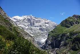
 The Schärhorn from the Maderanertal | |
| Elevation | 3,295 m (10,810 ft) |
| Prominence | 514 m (1,686 ft)[1] |
| Parent peak | Tödi |
| Location | |
 Schärhorn | |
| Location | Uri, Switzerland |
| Range | Glarus Alps |
| Coordinates | 46°49′37″N 8°49′45″E / 46.82694°N 8.82917°ECoordinates: 46°49′37″N 8°49′45″E / 46.82694°N 8.82917°E |
The Schärhorn is a mountain in the Glarus Alps near Klausen Pass. The highest summit is named Gross Schärhorn (3,295 m) while a second summit is named Chli Schärhorn (3,234 m). The mountain overlooks the valley of Schächental on the north side and the Hüfi Glacier in the Maderanertal on the south side. Both valleys are located in the canton of Uri.
References
External links
This article is issued from Wikipedia. The text is available under the Creative Commons Attribution/Share Alike; additional terms may apply for the media files.