Saticoy, California
| Saticoy | |
|---|---|
| census-designated place | |
 | |
 Saticoy | |
| Coordinates: 34°16′57″N 119°8′56″W / 34.28250°N 119.14889°WCoordinates: 34°16′57″N 119°8′56″W / 34.28250°N 119.14889°W | |
| Country |
|
| State |
|
| County | Ventura |
| Town established | 1861 |
| Named for |
Chumash name: Sa'aqtik'oy, "it is sheltered from the wind" [1] |
| Government | |
| • Type | N/A |
| • Senate | Tony Strickland (R) |
| • Assembly | Pedro Nava (D) |
| • U. S. Congress | Lois Capps (D) |
| Area[2] | |
| • Total | 0.373 sq mi (0.965 km2) |
| • Land | 0.373 sq mi (0.965 km2) |
| • Water | 0 sq mi (0 km2) 0% |
| Elevation[3] | 144 ft (44 m) |
| Population (2010) | |
| • Total | 1,029 |
| • Density | 2,800/sq mi (1,100/km2) |
| Time zone | Pacific (PST) (UTC-8) |
| • Summer (DST) | PDT (UTC-7) |
| ZIP Code | 93004 |
| Area code(s) | 805 |
| FIPS code | 06-84858 |
| GNIS feature IDs | 2585446[3] |
|
| |
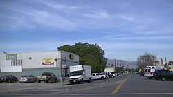
Saticoy is an unincorporated town and census-designated place (CDP)[3] in Ventura County, California. The population was 1,029 at the 2010 census. At the mouth of the Santa Clara River Valley, the community is southeast of the Santa Paula Freeway (State Route 126), and on the east end of the city of Ventura. On the fertile north bank of the Santa Clara River, the shore of the Santa Barbara Channel is 8 miles distant across Oxnard Plain. Saticoy is near an apex of this compound alluvial fan formed by the river and Calleguas Creek.[4] While formerly following a zig-zag route through the business district, State Route 118 now curves through the southerly portion of the townsite. Heading northwest to terminate at State Route 126, the highway is named Wells Road. Los Angeles Avenue is the name given to the highway as it heads east to connect with State Route 232.
The settlement, laid out in 1887,[5] is referred to as "Old Town." There are several historic buildings: Farmers & Merchants Bank, Walnut Growers Association Warehouse, and Saticoy Bean Warehouse.[6] These are related to the commercial hub that "Old Town" became with its close proximity to the railroad station.[7] While "Old Town" is mainly residential, there are also industrial uses.
West Saticoy[8] is an area west of Wells Road for which another map entitled "Town of Saticoy" was filed around the same time.[9] West Saticoy was the only area where the town lots as laid out on this map were developed. This small community is just west of the "School Lot" as shown on the map where Saticoy School was built in 1900.[10] Now part of the Ventura Unified School District, the school name has been changed to ATLAS Elementary: Academy of Technology and Leadership at Saticoy.[11] This alternative townsite, on the other side of the Brown Barranca[12] from the railroad station, was located on the main road to San Buenaventura. That distant town, incorporated in 1866, has grown so that all of Saticoy except for "Old Town" has been annexed into the City of Ventura.
Saticoy is located on part of the river's rich alluvial fan—one of three areas in the world that has 60 feet (18 m) of rich topsoil. Agriculture in the area includes avocados, lemons, oranges, strawberries, and many other row crops. Along the shore of the Santa Clara River, amidst the agriculture area east and northeast of the town is the Saticoy Oil Field, discovered in 1955 and operated by Vintage Petroleum.[13]
History
The earliest known human inhabitants of the vicinity were the Oak Grove People. Some ancient mealing stones of this prehistoric tribe were found near Saticoy in 1932 and traced back to about 3000 B.C. In about the early 15th century, the Chumash tribe inhabited the area. They built canoes and milled the acorns.[14]
The name Saticoy comes from the Chumash village named Sa'aqtik'oy (Chumash language: "it is sheltered from the wind").[15] It was one of the largest settlements of the Chumash region, which extended from Point Conception to Santa Monica and back into the foothills as far as the Coast Range.[16] The natural underground springs located in the area made Saticoy a prime location for the tribe to hold their yearly meetings.
Saticoy lies within the vast 17,773-acre (72 km2) Rancho Santa Paula y Saticoy granted to Manuel Jimeno Casarin on April 28, 1840 by the Mexican government.[17]
In November 1861, Jefferson L. Crane settled at the site of the Chumash village, and other Americans followed soon after. Saticoy, which was then 8 miles (13 km) from Ventura, had a school as early as 1868. W.D.F. Richards, considered the founder of Saticoy, arrived in 1868, and bought 650 acres (2.6 km2) of land. He contributed to the upbuilding of the community and followed many experiments in farming.[18]
The U.S. Post Office Department established Saticoy Post Office in 1873.[19] The streets and lots in the unincorporated present day "Old Town" were laid out in September 1887 on both sides of the "Southern Pacific Branch Line: Saugus to Santa Barbara."[5]
There have been many bridges across the Santa Clara River at Saticoy.[20] They were often washed out due to abundant rainfall and flooding.[21] The most notable washout, however, was due to the flood wave of water caused by the rupture of the St. Francis Dam, in northwest Los Angeles County, which occurred three minutes before midnight on March 12, 1928. The bridge was washed out again in the flood of 1969, and cars were rerouted through the riverbed east of the bridge while it was under repair.
Cabrillo Village
A "lengthy confrontation in the 1970s between farmworkers who lived at a rundown labor camp"[22] located between the river and the railroad track, about equidistant from "Old Town" and West Saticoy. "The growers wanted to raze the cramped homes for development." The confrontation "ended in 1976, when "82 farmworker families," advised by affordable housing advocate Rodney Fernandez, "pitched in and bought their deteriorating cottages from the Saticoy Lemon Assn.[23] It was perhaps the first time that U.S. farmworkers had purchased the camp they lived in."[24] [25] [26] In 1989 Cabrillo Village was selected as a finalist for the Rudy Bruner Award for Urban Excellence.[27]
Geography
According to the United States Census Bureau, the CDP covers an area of 0.4 square miles (1.0 km2), all of it land.
Demographics
The 2010 United States Census[28] reported that Saticoy had a population of 1,029. The population density was 2,760.7 people per square mile (1,065.9/km²). The racial makeup of Saticoy was 413 (40.1%) White, 9 (0.9%) African American, 29 (2.8%) Native American, 2 (0.2%) Asian, 0 (0.0%) Pacific Islander, 508 (49.4%) from other races, and 68 (6.6%) from two or more races. Hispanic or Latino of any race were 895 persons (87.0%).
The Census reported that 1,029 people (100% of the population) lived in households, 0 (0%) lived in non-institutionalized group quarters, and 0 (0%) were institutionalized.
There were 262 households, out of which 145 (55.3%) had children under the age of 18 living in them, 130 (49.6%) were opposite-sex married couples living together, 59 (22.5%) had a female householder with no husband present, 33 (12.6%) had a male householder with no wife present. There were 22 (8.4%) unmarried opposite-sex partnerships, and 3 (1.1%) same-sex married couples or partnerships. 29 households (11.1%) were made up of individuals and 9 (3.4%) had someone living alone who was 65 years of age or older. The average household size was 3.93. There were 222 families (84.7% of all households); the average family size was 4.08.
The population was spread out with 331 people (32.2%) under the age of 18, 133 people (12.9%) aged 18 to 24, 297 people (28.9%) aged 25 to 44, 177 people (17.2%) aged 45 to 64, and 91 people (8.8%) who were 65 years of age or older. The median age was 28.0 years. For every 100 females there were 109.1 males. For every 100 females age 18 and over, there were 106.5 males.
There were 278 housing units at an average density of 745.8 per square mile (288.0/km²), of which 94 (35.9%) were owner-occupied, and 168 (64.1%) were occupied by renters. The homeowner vacancy rate was 2.1%; the rental vacancy rate was 5.1%. 365 people (35.5% of the population) lived in owner-occupied housing units and 664 people (64.5%) lived in rental housing units.
References
- ↑ McCall, Lynne; Perry, Rosalind (2002). California’s Chumash Indians : a project of the Santa Barbara Museum of Natural History Education Center (Revised edition ed.). San Luis Obispo, Calif: EZ Nature Books. ISBN 0936784156.
- ↑ U.S. Census
- ↑ 3.0 3.1 3.2 U.S. Geological Survey Geographic Names Information System: Saticoy, California
- ↑ Thomas, H. E., and Others (1962) "Effects of Drought Along Pacific Coast in California: 1942-56" Geological Survey Professional Paper, Volume 372-G. United States Department of the Interior
- ↑ 5.0 5.1 "TOWN OF SATICOY" 3 MR 20. Ventura County Recorder Surveyed Sep. 1887, Recorded May 1, 1889. Retrieved October 28, 2013 from CountyView GIS: layer "Record Maps"
- ↑ City of Ventura "Saticoy and Wells Community Plan and Code Final Environmental Impact Report" EIR-2473 SCH# 2006081139. VOLUME 1, August 2009
- ↑ "AMENDED MAP OF THE TOWN OF SATICOY" 5 MR 36. Ventura County Recorder Surveyed Sep. 1887. Retrieved January 3, 2014 from CountyView GIS: layer "Record Maps"
- ↑ U.S. Geological Survey Geographic Names Information System: West Saticoy: Populated Place
- ↑ "TOWN OF SATICOY" 3 MR 15. Ventura County Recorder Surveyed March 1888, Recorded Oct. 1, 1888. Retrieved Retrieved January 3, 2014 from CountyView GIS: layer "Record Maps"
- ↑ U.S. Geological Survey Geographic Names Information System: Saticoy Elementary School
- ↑ Ventura Unified School District.Our History Retrieved January 7, 2014
- ↑ U.S. Geological Survey Geographic Names Information System: Brown Barranca
- ↑ "Feasibility Study Pursuant to Senate Bill 244 for Unincorporated Saticoy" City of Ventura. 2013. Section V. History of Saticoy. Page 10 (PDF p.12)
- ↑ "Relics Labeled Ancient Races --- Mealing Stones at Saticoy Traced by Expert --- Curator Places Age at More Than 5000 Years --- Oak Grove People Declared Owners of Metates." Los Angeles Times. May 20, 1932, from Ventura May 19. p. 6.
- ↑ "Chumash Placenames Still Surviving". Samala Chumash Language Tutorial. Retrieved 2009-05-24.
- ↑ "Indian Mealing Stones Found At West Saticoy." Los Angeles Times. May 3, 1932. p. A 16.
- ↑ "Spanish and Mexican Land Grants in Ventura County". Retrieved 2009-05-26.
- ↑ Storke, Mrs. Yda Addis (1891). A Memorial and Biographical History of the Counties of Santa Barbara, San Luis Obispo And Ventura, California. Chicago: Lewis. p. 217.
- ↑ "Saticoy [Ventura]". Durham's Place-Names of Greater Los Angeles: Includes Los Angeles, Orange and Ventura Counties. 2001. p. 161.
- ↑ MITCHELL, J.E.. (1994-7-30) "SATICOY : Completion of Bridge Will Be Celebrated" Los Angeles Times WEST VENTURA COUNTY FOCUS Retrieved 2013-10-29.
- ↑ FARLEY, SHANNON. 1990-1-18) New Saticoy Bridge Demanded Los Angeles Times Retrieved 2013-10-29.
- ↑ U.S. Geological Survey Geographic Names Information System: Saticoy, California
- ↑ Saticoy Lemon Association Official Website
- ↑ Chawkins, Steve (2013-10-25). "Rodney Fernandez dies at 68; fought for affordable housing". Los Angeles Times. Retrieved 2013-10-27.
- ↑ "Cabrillo Village" Cabrillo Economic Development Corporation Website. Accessed 28 October 2013
- ↑ Guskind, Robert and Peirce, Neil R. Breakthroughs: Recreating the American City 1989 Rudy Bruner Award for Urban Excellence. Chapter 5 Farm Workers' Own Housing: Self-Help in Cabrillo Village
- ↑ "Rudy Bruner Award for Urban Excellence". Winners & Case Studies. Bruner Foundation. 2013. Retrieved 7 January 2014.
- ↑ All data are derived from the United States Census Bureau reports from the 2010 United States Census, and are accessible on-line here. The data on unmarried partnerships and same-sex married couples are from the Census report DEC_10_SF1_PCT15. All other housing and population data are from Census report DEC_10_DP_DPDP1. Both reports are viewable online or downloadable in a zip file containing a comma-delimited data file. The area data, from which densities are calculated, are available on-line here. Percentage totals may not add to 100% due to rounding. The Census Bureau defines families as a household containing one or more people related to the householder by birth, opposite-sex marriage, or adoption. People living in group quarters are tabulated by the Census Bureau as neither owners nor renters. For further details, see the text files accompanying the data files containing the Census reports mentioned above.
External links
| |||||||||||||||||
