Santiago
| Santiago de Chile | ||||||
|---|---|---|---|---|---|---|
 | ||||||
| Nickname(s): Chago' | ||||||
| Coordinates: 33°27′0″S 70°40′0″W / 33.45000°S 70.66667°WCoordinates: 33°27′0″S 70°40′0″W / 33.45000°S 70.66667°W | ||||||
| Country |
| |||||
| Region |
| |||||
| Province | Santiago Province | |||||
| Foundation | 12 February 1541 | |||||
| Area | ||||||
| • City | 641 km2 (247.6 sq mi) | |||||
| Elevation | 520 m (1,706 ft) | |||||
| Population (2012) | ||||||
| • City | 308,000 | |||||
| • Density | 8,470/km2 (21,925/sq mi) | |||||
| • Urban | 308,027 | |||||
| • Metro | 6.3 million | |||||
| Demonym | Santiaguinos (-as) | |||||
| Time zone | CLT (UTC−4) | |||||
| • Summer (DST) | CLST (UTC−3) | |||||
| Postal code | 8320000 | |||||
| Area code(s) | +56 2 | |||||
| Website | Official website | |||||

.svg.png)

Santiago (Spanish pronunciation: [san̪ˈtja.ɣo]), also Santiago de Chile [san̪ˈtja.ɣo ðe ˈtʃi.le] (![]() ), is the capital of Chile and the center of its largest conurbation. It is located in the country's central valley, at an elevation of 520 m (1,706 ft) above mean sea level.
), is the capital of Chile and the center of its largest conurbation. It is located in the country's central valley, at an elevation of 520 m (1,706 ft) above mean sea level.
Founded in 1541, Santiago has been the capital city since colonial times. The city has a downtown core of 19th century neoclassical architecture and winding side-streets, dotted by art deco, neo-gothic, and other styles. Santiago's cityscape is shaped by several stand-alone hills and the fast-flowing Mapocho River, lined by parks such as Parque Forestal. Mountains of the Andes chain can be seen from most points in the city. These mountains contribute to a considerable smog problem, particularly during winter. The city outskirts are surrounded by vineyards, and Santiago is within a few hours of both the mountains and the Pacific Ocean.
Santiago's steady economic growth over the past few decades has transformed it into a modern metropolis. The city is now home to growing theater and restaurant scenes, extensive suburban development, dozens of shopping centers, and a rising skyline, including the tallest building in Latin America, the Gran Torre Santiago. It includes several major universities, and has developed a modern transportation infrastructure, including a free flow toll-based, partly underground urban freeway system and the Metro de Santiago, South America's most extensive subway system. Santiago is the cultural, political and financial center of Chile and is home to the regional headquarters of many multinational corporations. The Chilean executive and judicial powers are located in Santiago, but Congress meets in nearby Valparaíso.
Santiago is named after the biblical figure James, son of Zebedee (Sant Iago = Saint Iacob = Saint Jacob = Saint James).
Usage note

In Chile, there are several entities which bear the name of "Santiago" that are often confused. The Municipality of Santiago, sometimes referred to as "downtown" or "Central Santiago" (Santiago Centro), is an administrative division that comprises roughly the area occupied by the city during its colonial period. The municipality headed by a mayor is part of the Santiago Province headed by a provincial governor, which is in itself a subdivision of the Santiago Metropolitan Region headed by an intendant. Despite these classifications, when the term "Santiago" is used without another descriptor, it usually refers to what is also known as Greater Santiago (Gran Santiago), a territorial extension defined by its urban continuity that includes the Commune of Santiago in addition to 36 other communes, which together comprise the majority of the Santiago Province and some areas of neighboring provinces (see Political divisions).
The city and region's demonym is santiaguinos (male) and santiaguinas (female).
History
Founding of the city
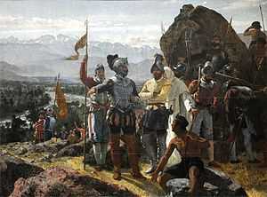
Santiago is the capital of Chile. It was founded by Spanish Conquistador Pedro de Valdivia on 12 February 1541, with the name Santiago de Nueva Extremadura, as a homage to Saint James and Extremadura and in relation with the first name given to Chile, Nueva Extremadura. Extremadura was Valdivia's birthplace in Spain.[1] The founding ceremony was held on Huelén Hill (later renamed Cerro Santa Lucía). Valdivia chose the location of Santiago because of its climate, abundant vegetation, and the ease with which it could be defended—the Mapocho River then split into two branches and rejoined further downstream, forming an island.[2] The Inca ruler Manco Cápac II warned the new rulers that his people would be hostile to the occupiers. The Spanish invaders had to battle against hunger caused by this resistance. Pedro de Valdivia ultimately succeeded in stabilizing the food supply and other resources needed for Santiago to thrive.[3]
The layout of the new town consisted of straight roads of 12 varas (14.35 m or 47.1 ft) width, in equal intervals of 138 varas (165.08 m or 541.6 ft) perpendicular to each other. With nine roads in the east–west direction and 15 in the north–south direction, there were 126 blocks that formed the so-called manzanas, or square cut.[4]
Attempted destruction
Continued resistance by the indigenous population resulted in a series of further conflicts. On 11 September 1541, the Picunche chief, Michimalonco, led an attack on Santiago, beginning a three-year-long war. At the time, the Conquistadores were in a precarious situation, suffering persistent food shortages in almost complete isolation from the rest of the world.[5]
In January 1542, Pedro de Valdivia sent an emissary, Alonso de Monroy, to Peru to request help. The Conquistadors suffered 20 harsh months until de Monroy returned from Peru with reinforcements, ending the isolation and demoralizing situation of the soldiers in Santiago. The uprising ultimately failed and the indigenous population moved south.[5]
Colonial Santiago

Despite threats from Indian attacks and natural disasters such as earthquakes, and floods, Santiago was rapidly settled.[citation needed] Of the 126 blocks designed by Gamboa in 1558, 40 were occupied by 1580, while nearby lands supported tens of thousands of livestock. These early settlers constructed the first important buildings in the city, including the first Cathedral in 1561 and the Church of San Francisco, built in 1618.[6] Both structures were built primarily of adobe and stone.

In 1767, the corregidor Luis Manuel de Zañartu began construction on the Calicanto Bridge, one of the most important architectural works of the entire colonial period in Chile. The bridge was completed in 1779 and linked the two halves of the city across the Mapocho River.
In 1770, Governor Agustín de Jáuregui hired the Italian architect Joaquín Toesca to design, among other important works, the façade of the Santiago Metropolitan Cathedral and La Moneda, the presidential palace. [7] The government of Ambrosio O'Higgins opened a major road to Valparaíso in 1791.
Independence

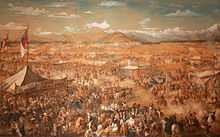
On 12 February 1817, the Battle of Chacabuco was fought a short distance north of Santiago in the town of Colina. Argentine and Chilean armies, led by José de San Martín and Bernardo O'Higgins, fought Spanish royalists. On the same day, Chile proclaimed its independence.[5]
During the authoritarian era of the so-called Republic, from 1830 to 1891, the school system was introduced and cultural life started to flourish. In 1843 the Universidad de Chile was founded, followed by the Pontificia Universidad Católica in 1888. By 1885, the population of Santiago had reached 189,322.[5]
Nineteenth century
During the years of the Republican era, institutions such as the University of Chile (Universidad de Chile), the Normal School of Preceptors, the School of Arts and Crafts, and the Quinta Normal, which included the Museum of Fine Arts (now Museum of Science and Technology) and the National Museum of Natural History, were founded. Created primarily for educational use, they also became examples of public planning during that period. In 1851, the first telegraph system connecting the capital with the Port of Valparaíso was inaugurated.[5]

A new momentum in the urban development of the capital took place during the so-called "Liberal Republic" and the administration Mayor Benjamín Vicuña Mackenna. Among the main works during this period are the remodeling of the Cerro Santa Lucía which, despite its central location, had been in very poor shape.[5] In an effort to transform Santiago, Vicuña Mackenna began construction of the Camino de Cintura, a road surrounding the entire city. A new redevelopment of the Alameda Avenue turned it into the main traffic artery of the city.
Also during this time and with the work of European landscapers in 1873, O'Higgins Park came to existence. The park, open to the public, became a point of interest in Santiago due to its large gardens, lakes, and carriage trails. Other important buildings were opened during this era, such as the Teatro Municipal opera house, and the Club Hípico de Santiago. At the same time, the 1875 International Exposition was held in the grounds of the Quinta Normal.[8]
The city became the main hub of the national railway system. The first railroad reached the city on 14 September 1857, at the Santiago Estación Central railway station. Under construction at the time, the station would be opened permanently in 1884. During those years, railways connected the city to Valparaíso as well as regions in the north and south of Chile. The streets of Santiago were paved and by 1875 and there were 1,107 cars in the city, while 45,000 people used tram services on a daily basis.
Growth and development
The 1930s saw the beginning of a transformation of Santiago into a modern, industrialized city. In the following decades, Santiago flourished and continued to grow rapidly due to emigration from Chile's northern and southern regions.[9] In 1940 the city was home to 952,075 people, rising to 1,350,409 in 1952 and 1,907,378 by 1960.[9]
-

Map of Santiago in 1895
-

Santiago in 1891
-

Santiago in 1930
-

Greater Santiago, 1965
Along with growth came the appearance of poverty-stricken neighborhoods in some areas of the city, while rural areas on the periphery of the city were increasingly urbanized. In 1930 the urban city center had an area of 6,500 hectares, increasing to 20,900 by 1960 and 38,296 by 1980. Although most of the communities continued to expand, growth was concentrated in outlying communities such as Barrancas to the west of the city, Conchalí to the north, La Cisterna and La Granja to the south. The wealthier sections of society became concentrated in areas such as Las Condes and La Reina. In contrast, the center of Santiago gradually decreased in population, leaving space for the development of trade, banking, and government activities.[10]
While the majority of Santiago's growth took place without any regulation, various development plans for Greater Santiago began to be implemented in the late 1950s. In 1958 a plan was launched to regulate urban areas, setting a size limit of 38,600 hectares for the city, for a maximum population of 3,260,000 inhabitants. New roads such as the Avenida Américo Vespucio Ring Road and the Pan American Highway were constructed, while existing industrial centers were enlarged and new ones established. The hosting of the World Cup in 1962 gave new impetus to the improvement of public works within the city. In 1966 the Metropolitan Park of Santiago was established in the Cerro San Cristóbal and the Department of Housing and Urban Planning (Ministerio de Vivienda y Urbanismo, MINVU) began eradicating shanty towns, replacing them with new homes. San Borja, built near the Diego Portales Building, was also remodeled at this time.[10]
The new international Pudahuel Airport opened in 1968 and, after years of debate, construction of the Santiago Metro began in 1969 and was completed in 1975. The Metro was very successful and in subsequent years expanded, comprising two perpendicular lines by the end of 1978. Telecommunications were improved with the construction of the Torre Entel in 1975, which would become one of the symbols of the capital and the tallest structure in the country for two decades.[10]
After the 1973 Chilean coup d'état and the establishment of a military regime, no major changes were made to urban planning until the beginning of 1980, when the government adopted a neoliberal economic model and took on the role of supervisor of a market economy. In 1979 the master plan was amended, extending the urban area to more than 62,000 hectares. Expansion has been particularly acute in La Florida, the country's most populous municipality, with 328,881 inhabitants at the time of the 1992 census.
A strong earthquake struck the city on 3 March 1985, causing few casualties but leaving thousands homeless and destroying many old buildings.[10] Another earthquake, on 27 February 2010, caused massive destruction and hundreds of deaths in other regions of Chile, but there was little damage in Santiago and only 23 fatalities were reported.[11]
Population explosion

The 1920 census estimated the population of Santiago to be 507,296 inhabitants, equivalent to 13.6% of the population of Chile. This represented an increase of 52.47% from the census of 1907, i.e. an annual growth of 3.3%, almost three times the national figure. This growth was mainly due to the arrival of farmers from the south who came to work in factories and railroads under construction. However, this growth was experienced in the periphery and not in the town itself.

In these years, the downtown district was consolidated as a commercial, financial and administrative center, with the establishment of various portals and local around Ahumada Street and Civic District in the immediate surroundings of the Palace of La Moneda. The latter project involved the construction of various modernist buildings for the establishment of the offices of ministries and other public services, kicking off for the construction of medium-rise buildings. On the other hand, the traditional inhabitants of the center began to migrate out of the city to more rural areas like Providencia and Ñuñoa, which hosted the oligarchy and the European immigrant professionals, and San Miguel for middle-class families. Furthermore, in the periphery villas were built various partners from various organizations of the time. Modernity expanded in the city, with the appearance of the first theaters, the extension of the telephone network and the opening of the Airport Los Cerrillos in 1928, among other advances.
The feeling that the early 20th century was an era of economic growth due to technological advances contrasted dramatically with the standard of living of lower social classes. The growth of the previous decades led to an unprecedented population explosion starring in 1929. The Great Depression caused the collapse of the nitrate industry in the north, leaving 60,000 unemployed, which added to the decline in agricultural exports, totaled about 300,000 unemployed nationwide. These unemployed workers saw Santiago and its booming industry as the only chance to survive. Many migrants arrived in Santiago with nothing and thousands had to survive on the streets because of the great difficulty of finding a place they could rent. Widespread disease, including tuberculosis, claimed the lives of hundreds of homeless. Unemployment and living costs increased dramatically while the salaries of the people of Santiago fell.
The situation would change only several years later with a new industrial boom fostered by CORFO and the expansion of the state apparatus from the late 1930s. At this time, the aristocracy lost much of the power he held and the middle class, composed of merchants, bureaucrats and professionals, acquired the role of national policy. In this context, Santiago began to develop a substantial middle- and lower-class population, while the upper classes sought refuge in the districts of the capital. Thus, the old moneyed class trips, as Cousino and Alameda Park, lose hegemony against popular entertainment venues such as the National Stadium emerged in 1938.
Geography
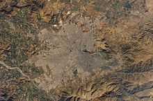
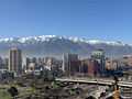
The city lies in the center of the Santiago Basin, a large bowl-shaped valley consisting of a broad and fertile lands surrounded by mountains. The city has a varying elevation, with 400 m (1,312 ft) in the western areas and 540 m (1,772 ft) at the Plaza Baquedano.[12] It is flanked by the main chain of the Andes to the east and the Chilean Coastal Range to the west. On the north, it is bounded by the Cordón de Chacabuco, a mountain range of the Andes. The Andes mountains around Santiago are quite tall; the tallest is the Tupungato volcano at 6,570 m (21,555 ft). Other volcanoes include Tupungatito, San José, and Maipo. Cerro El Plomo is the highest mountain visible from Santiago's urban area. The Mapocho River flows through the city. At the southern border lies the Angostura de Paine, an elongated spur of the Andes that almost reaches the coast. The Santiago Basin is part of the Intermediate Depression and is remarkably flat, interrupted only by a few hills; among them are Cerro Renca, Cerro Blanco, and Cerro Santa Lucía. This basin is approximately 80 kilometres (50 miles) in a north–south direction and 35 km (22 mi) from east to west.
To the east stands the massive Sierra de Ramón, a mountain chain formed in the foothills of the Precordillera due to the action of the San Ramón Fault, reaching 3296 metres at the Cerro de Ramón. 20 km (12 mi) further east is the Cordillera of the Andes with its mountain ranges and volcanoes, many of which exceed 6,000 m (19,690 ft) and in which some glaciers are present.
During recent decades, urban growth has expanded the boundaries of the city to the east closer to the Andean Precordillera. In areas such as La Dehesa, Lo Curro, and El Arrayan, urban development is present at over 1,000 metres of altitude.[13]
-

Ski Center El Colorado
-

Cerro San Cristobal
-

Santiago in winter
-

Santiago in summer
Climate
Santiago has a somewhat cool Mediterranean climate: relatively hot dry summers (November to March) with temperatures reaching up to 35 °C (95 °F) on the hottest days; winters (June to August) are more humid with cold mornings; typical maximum daily temperatures of 13 °C (55 °F), and minimums of a few degrees above freezing. According to the Köppen climate classification, the climate in Santiago is Csb, and it closely borders a semi-arid climate (BSk).
Mean rainfall is 360 mm (14.2 in) per year and is heavily concentrated in the cooler months. Snowfall is rare in eastern districts, and extremely rare in most of the city.[14]
| Climate data for Comodoro Arturo Merino Benítez International Airport, Santiago (1970–2000) | |||||||||||||
|---|---|---|---|---|---|---|---|---|---|---|---|---|---|
| Month | Jan | Feb | Mar | Apr | May | Jun | Jul | Aug | Sep | Oct | Nov | Dec | Year |
| Record high °C (°F) | 36.1 (97) |
36.2 (97.2) |
36.7 (98.1) |
31.9 (89.4) |
29.8 (85.6) |
26.5 (79.7) |
27.5 (81.5) |
29.2 (84.6) |
32.4 (90.3) |
32.4 (90.3) |
33.7 (92.7) |
34.5 (94.1) |
36.7 (98.1) |
| Average high °C (°F) | 29.4 (84.9) |
28.9 (84) |
26.9 (80.4) |
22.8 (73) |
18.2 (64.8) |
14.8 (58.6) |
14.3 (57.7) |
16.2 (61.2) |
18.4 (65.1) |
22.0 (71.6) |
25.3 (77.5) |
28.1 (82.6) |
22.1 (71.8) |
| Daily mean °C (°F) | 20.7 (69.3) |
19.9 (67.8) |
17.8 (64) |
14.3 (57.7) |
10.9 (51.6) |
8.3 (46.9) |
7.7 (45.9) |
9.2 (48.6) |
11.3 (52.3) |
14.2 (57.6) |
17.0 (62.6) |
19.5 (67.1) |
14.2 (57.6) |
| Average low °C (°F) | 11.8 (53.2) |
11.1 (52) |
9.4 (48.9) |
6.9 (44.4) |
4.9 (40.8) |
3.3 (37.9) |
2.5 (36.5) |
3.4 (38.1) |
5.2 (41.4) |
7.2 (45) |
9.0 (48.2) |
10.9 (51.6) |
7.1 (44.8) |
| Record low °C (°F) | 2.7 (36.9) |
0.1 (32.2) |
1.0 (33.8) |
−3.4 (25.9) |
−5.8 (21.6) |
−6.0 (21.2) |
−6.0 (21.2) |
−5.6 (21.9) |
−4.5 (23.9) |
−2.7 (27.1) |
0.0 (32) |
1.0 (33.8) |
−6.0 (21.2) |
| Precipitation mm (inches) | 0.3 (0.012) |
1.3 (0.051) |
3.8 (0.15) |
12.9 (0.508) |
44.2 (1.74) |
69.8 (2.748) |
69.3 (2.728) |
38.1 (1.5) |
22.5 (0.886) |
11.0 (0.433) |
7.0 (0.276) |
1.7 (0.067) |
281.9 (11.098) |
| Avg. precipitation days | 0 | 0 | 1 | 3 | 5 | 7 | 7 | 6 | 5 | 2 | 1 | 0 | 37 |
| % humidity | 57 | 60 | 65 | 71 | 80 | 84 | 84 | 81 | 78 | 71 | 63 | 58 | 71 |
| Mean monthly sunshine hours | 322 | 280 | 265 | 185 | 117 | 91 | 110 | 138 | 158 | 208 | 267 | 321 | 2,462 |
| Source #1: Dirección Meteorológica de Chile[15] | |||||||||||||
| Source #2: Danish Meteorological Institute (sun)[16] | |||||||||||||
| Santiago (SCL airport) | ||||||||||||||||||||||||||||||||||||||||||||||||||||||||||||
|---|---|---|---|---|---|---|---|---|---|---|---|---|---|---|---|---|---|---|---|---|---|---|---|---|---|---|---|---|---|---|---|---|---|---|---|---|---|---|---|---|---|---|---|---|---|---|---|---|---|---|---|---|---|---|---|---|---|---|---|---|
| Climate chart (explanation) | ||||||||||||||||||||||||||||||||||||||||||||||||||||||||||||
| ||||||||||||||||||||||||||||||||||||||||||||||||||||||||||||
| ||||||||||||||||||||||||||||||||||||||||||||||||||||||||||||
Among the main climatic features of Santiago is the concentration of about 80% of the precipitation during the winter months (May to September), varying between 50 and 80 mm of rainfall (2 to 3 1/8″) during these months. That amount contrasts with figures for the months corresponding to a very dry season, caused by an anticyclonic dominance continued for about seven or eight months, mainly during the summer months between December and March. Rainfall does not exceed 4 mm (3/16″) on average. Precipitation is usually only rain, as snowfall only occurs in the Andes and in the Precordillera. In winter, the snow line is about 2,100 metres (6,890 ft), and it ranges from 1500 metres (4900 feet) up to 2900 metres (9500 feet).[14]
Temperatures vary throughout the year from an average of 20 °C (68 °F) in January to 8 °C (46 °F) in June and July. In the summer, January is hot, easily reaching over 30 °C (86 °F) and a record high close to 37 °C (99 °F), while nights are generally pleasant and slightly cooler, at 15 °C (59 °F). During autumn and winter the temperature drops, and is slightly lower than 10 °C (50 °F). The temperature may even drop to 0 °C (32 °F), especially during the morning. The historic low of −6.8 °C (20 °F) was in 1976.[citation needed]
Santiago's location within a watershed is one of the most important factors determining the climate of the city. The coastal mountain range serves as a screen that stops the spread of maritime influence, contributing to the increase in annual and daily thermal oscillation (the difference between the maximum and minimum daily temperatures can reach 14°C) and maintaining low relative humidity, close to an annual average of 70%. It also prevents the entry of air masses, with the exception of some coastal low clouds that penetrate to the basin through the river valleys.[citation needed]
Prevailing winds are from the southwest, with an average of 15 km/h (9 mph), especially during the summer; the winter is less windy.
Environmental issues
Thermal inversion (a meteorological phenomenon whereby a stable layer of warm air holds down colder air close to the ground) causes high levels of smog and air pollution to be trapped and concentrated within the Central Valley during winter months. In the 1990s air pollution fell by about one-third, but there has been little progress since 2000.[17] Particulate matter air pollution is a serious public health concern in Santiago, with atmospheric concentrations of PM2.5 and PM10 regularly exceeding standards established by the US Environmental Protection Agency and World Health Organisation.[18]
As of March 2007, only 61% of the wastewater in Santiago was treated,[19] which increased up to 71% by the end of the same year. However, the Mapocho River, which crosses the city from the northeast to the southwest of the Central Valley, remains contaminated by household, agricultural, and industrial sewage, and by upstream copper-mining waste (there are a number of copper mines in the Andes east of Santiago), which is dumped untreated into the river.[20] Laws exist which require industries and local governments to treat all wastewater discharges, but these regulations are often loosely enforced.[21] There are now a number of large wastewater processing and recycling plants under construction, and ongoing plans to decontaminate the river[22] and make it navigable.[23] In March 2012, the Mapocho Wastewater Treatment Plant began operations, increasing the wastewater treatment capacity of the city to 100%, making Santiago the first capital city in Latin America to treat all of its municipal sewage.[24]
Noise levels on the main streets are high,[25] mostly because of noisy diesel buses. Diesel trucks are also major contributors to winter smog. A lengthy replacement process of the transit system that began in 2005 was ended in 2010. A major source of Santiago air pollution year-round is the smelter of the El Teniente copper mine.[26][27] The government does not usually report it as being a local pollution source, as it is just outside the reporting area of the Santiago Metropolitan Region, being 110 kilometres (68 mi) from downtown.[28][29]

Urban issues
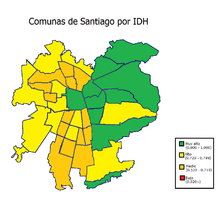
As is typical for Chile,[30] Santiago is an economically divided city (Gini coefficient of 0.47).[31] The western half (zona poniente) of the city is, on average, much poorer than the eastern communes, where the high-standard public and private facilities are concentrated.
In Santiago, as with much of Chile, stray dogs are very common.[32][33] However, rabies is practically non-existent in Chile.[34]
Demographics
According to data collected in the 2002 census by the National Institute of Statistics, the Santiago metropolitan area population reached 5,428,590 inhabitants, equivalent to 35.91 per cent of the national total and 89.56 per cent of total regional inhabitants. This figure reflects broad growth in the population of the city during the 20th century: in 1907 it had 383,587 inhabitants; 1,010,102 in 1940; 2,009,118 in 1960; 3,899,619 in 1982; and 4,729,118 in 1992.[35] (percentage of total population, 2007)[36]

The growth of Santiago has undergone several changes over the course of its history. In its early years, the city had a rate of growth 2.68% annually until the 17th century, then down to less than 2% per year until the early 20th century figures. During the 20th century, Santiago experienced a demographic explosion as it absorbed migration from mining camps in northern Chile during the economic crisis of the 1930s. The population surged again via migration from rural sectors between 1940 and 1960. This migration was coupled with high fertility rates, and annual growth reached 4.92% between 1952 and 1960. Growth has declined, reaching 1.35% in the early 2000s. The size of the city expanded constantly; The 20,000 hectares Santiago covered in 1960 doubled by 1980, reaching 64,140 hectares in 2002. The population density in Santiago is 8,464 inhabitants/km².
The population of Santiago[35] has seen a steady increase in recent years. In 1990 the total population under 20 years was 38.04% and 8.86% were over 60. Estimates in 2007 show that 32.89% of men and 30.73% of women were less than 20 years old, while 10.23% of men and 13.43% of women were over 60 years. For the year 2020, it is estimated that the figures will be 26.69% and 16.79%.
4,313,719 people in Chile say they were born in one of the communes of the Santiago Metropolitan Region,[35] which according to the 2002 census, amounts to 28.54% of the national total. 67.6% of the current inhabitants of Santiago claim to been born in one of the communes of the metropolitan area. 2.11% of the inhabitants are immigrants, mainly from other Latin American countries such as Argentina and Peru.
Economy

Santiago is the industrial and financial center of Chile, and generates 45% of the country's GDP.[37] Some international institutions, such as ECLAC (Economic Commission for Latin America and the Caribbean), have their offices in Santiago. Currently under construction is the Costanera Center, a mega project in Santiago's Financial District. This includes a 280,000-square-metre (3,000,000 sq ft) mall, a 300-meter (980 ft) tower, two office towers of 170 meters (558 ft) each, and a hotel 105 meters (344 ft) tall. In January 2009 the retailer in charge, Cencosud, said in a statement that the construction of the mega-mall would gradually be reduced until financial uncertainty is cleared.[38] In January 2010, Cencosud announced the restart of the project, and this was taken generally as a symbol of the country's success over the global financial crisis. Close to Costanera Center another skyscraper is already in use, Titanium La Portada, 190 meters (623 ft) tall. Although these are the two biggest projects, there are many other office buildings under construction in Santiago, as well as hundreds of high rise residential buildings. In February 2011, Gran Torre Santiago, part of the Costanera Center project, located in the called Sanhattan district, reached the 300-meter mark, officially becoming the tallest structure in Latin America.[39] The strong economy and low government debt is attracting migrants from Europe and the United States.[40]


Commerce
The bulk of Chile's industrial and commercial activity is concentrated in the national and regional capital of Santiago, but there are important farm-supply, marketing, and processing activities at San Bernardo (location of major railroad shops), Puente Alto (a paper- and gypsum-processing center), Melipilla, Talagante, and Buin. Dairy and beef production are significant; the main crops are grains, grapes, potatoes, and beans. Copper, gypsum, and limestone are mined. Marketing is facilitated by the proximity of urban centers, by main-line railroad communications, and by the best-developed regional road system in Chile.
Santiago is Chile's retail capital. Falabella, Paris, Johnson, Ripley, La Polar, and several other department stores dot the mall landscape of Chile. The east side neighborhoods like Vitacura, La Dehesa, and Las Condes are home to Santiago's Alonso de Cordova street, and malls like Parque Arauco, Alto Las Condes, and Costanera Center are known for their luxurious shopping. Alonso de Cordova, Santiago's equivalent to Rodeo Drive or Rua Oscar Freire in São Paulo, has exclusive stores like Louis Vuitton, Hermès, Emporio Armani, Salvatore Ferragamo, Ermenegildo Zegna, Swarovski, MaxMara, Longchamp, and others. Alonso de Cordova also houses some of Santiago's most famous restaurants, art galleries, wine showrooms and furniture stores. The Costanera Center has stores like Armani Exchange, Banana Republic, Façonnable, Hugo Boss, Swarovski, and Zara. There are plans for a Saks Fifth Avenue in Santiago. Several mercados in the city sell local goods. Barrio Bellavista is where some of the most exclusive night clubs and chic cafes are located.
Transport
Air

Comodoro Arturo Merino Benítez International Airport (IATA: SCL) is Santiago's national and international airport and the principal hub of LAN Airlines, Sky Airline, One Airlines, Aerocardal and PAL Airlines. The airport is located in the western commune of Pudahuel. The largest airport in Chile, it is ranked sixth in passenger traffic among Latin American airports, with 14,168,282 passengers served in 2012—a 17.04% increase over 2011.[41] It is located 15 km from the city centre.
Santiago is also served by Eulogio Sánchez Airport (IATA: SCTB), a small, privately owned general aviation airport in the commune of la Reina.
Rail
Trains operated by Chile's national railway company, Empresa de los Ferrocarriles del Estado (EFE), connect Santiago to several cities in the south-central part of the country: Rancagua, San Fernando, Talca (connected to Constitución by another train service), Linares and Chillán. All such trains arrive and depart from the Estación Central railway station (Central Station), which can be accessed by bus or subway.[42]
Inter-urban buses
Bus companies provide passenger transportation from Santiago to most areas of the country, while some also provide parcel shipping and delivery services. There are several bus terminals in Santiago:
- Terminal San Borja: located in Metro station "Estación Central". Provides buses to all destinations in Chile and to some towns around Santiago.
- Terminal Alameda: located in Metro station "Universidad de Santiago". Provides buses to all destinations in Chile.
- Terminal Santiago: located one block west of Terminal Alameda. Provides buses to all destinations in Chile as well as destinations in most countries in South America, except Bolivia.
- Terrapuerto Los Héroes: located two blocks east of Metro station "Los Héroes". Provides buses to south of Chile and some northern cities, as well as Argentina (Mendoza and Buenos Aires) and Paraguay (Asunción).
- Terminal Pajaritos: located in Metro station "Pajaritos". Provides buses to the international airport, inter-regional services to Valparaíso, Viña del Mar and several other coastal cities and towns.
- Terminal La Cisterna: located in Metro station "La Cisterna". Provides buses to towns around southern Santiago, Viña del Mar, Temuco and Puerto Montt.
- Terminal La Paz: located about two blocks away from the fresh fruit and vegetables market "Vega Central"; the closest Metro station is "Puente Cal y Canto". It connects the rural areas north of Santiago.
Highways
A network of free flow toll highways connect the various areas of the city. They include the Vespucio Norte and Vespucio Sur highways, which surround the city completing a nearly full circle; Autopista Central, the section of the Pan American highway crossing the city from north to south, divided in two highways 3 km (2 mi) apart; and the Costanera Norte, running next to the Mapocho River and connecting the international airport with the downtown and with the wealthier areas of the city to the east, where it divides into two highways.
Other non-free flow toll roads connect Santiago to other cities. Rutas del Pacífico (Ruta 68), the continuation of the Alameda avenue to the west, provides direct access to Valparaíso and Viña del Mar; Autopista del Sol (Ruta 78), connects Melipilla and the port of San Antonio with the capital; Autopista del Maipo is an alternative to the Pan American highway to access the various localities south of Santiago; Autopista Los Libertadores provides access to the main border crossing to Argentina, via Colina and Los Andes; and Autopista Nororiente, which provides access to the suburban development known as Chicureo, north of the capital.
Public transport

Santiago has 37% of Chile's vehicles, with a total of 991,838 vehicles, 979,346 of which are motorized. 805,220 cars pass through the city, which is equivalent to 38% of the national total, and at a rate of one car for every seven people.[citation needed] An extensive network of streets and avenues stretching across Santiago facilitate travel between the different communities that make up the metropolitan area.
In the 1990s the government attempted to reorganize the public transport system. New routes were introduced in 1994 and the buses were painted yellow. The system, however, had serious issues with routes overlapping, high levels of air and noise pollution, and safety problems for both riders and drivers. To tackle these issues a new transport system, called Transantiago, was devised. The system was launched in earnest on 10 February 2007, combining core services across the city with the subway and with local feeder routes, under a unified system of payment through a contactless smartcard called "Tarjeta bip!". The change was not well received by users, who complained of lack of buses, too many bus-to-bus transfers, and diminished coverage. Some of these problems were resolved, but the system earned a bad reputation which it hasn't been able to shake off. As of 2011, the fare evasion rate is stubbornly high.

The Metro de Santiago subway carries over two million passengers daily through its five lines (1, 2, 4, 4A, and 5), extending over 84 km (52 mi) and 108 stations. In 2010 a new extension to the commune of Maipú expanded the Metro to more than 105 km (65 mi) in length. Construction of two new lines (3 and 6) was confirmed recently by president Sebastián Piñera, and are expected to be operating in 2016.[43]
In recent years many cycle paths have been constructed, but so far the number is limited and with little connections between the routes. Most cyclists ride on the street, and the use of helmets and lights is not widespread, even though it is mandatory.
Metro


With 100 stations currently in operation and 19 other planned or under construction, the Santiago Metro is South America's most extensive metro system. The system has five operating lines and carries around 2,400,000 passengers per day. Two underground lines (Line 4 and 4A) and an extension of Line 2 were inaugurated in 2005 and 2006.[44] Further extensions are currently under way on Lines 1 and 5.[45] The South Express Line, Line 6, will be finished by 2014, adding 12 stations to the network and approximately 15 km (9 mi) of track.[45]
Commuter rail
EFE provides suburban rail service under the brandname of Metrotren. There is only one southbound route, serving 18 stations between Santiago's Central Station and San Fernando, via Rancagua. The electrified service expands over 138 km (86 mi). About 10 daily trains operate the full distance in each direction, with up to 30 trains between Santiago and Graneros.[46]
Bus
Transantiago is the name for the city's public transport system. It works by combining local (feeder) bus lines, main bus lines, and the Metro network. It includes an integrated fare system, which allows passengers to make bus-to-bus or bus-to-metro transfers for the price of one ticket, using a contactless smartcard. Fares cannot be paid in cash, and if the card does not have enough credit, it must be recharged before a trip.
Taxi
Taxicabs are common in Santiago and are painted black with yellow roofs and have orange license plates. So-called radiotaxis may be called up by telephone and can be any make, model, or color but should always have the orange plates. Colectivos are shared taxicabs that carry passengers along a specific route for a fixed fee.
Political divisions
Greater Santiago lacks a metropolitan government for its administration, which is currently distributed between various authorities, complicating the operation of the city as a single entity.[47] The highest authority in Santiago is considered to be the intendant of the Santiago Metropolitan Region, an unelected delegate of the president.
The whole of Greater Santiago does not fit perfectly into any administrative division, as it extends into four different provinces and 37 communes. The majority of its 641.4 km2 (247.65 sq mi) (as of 2002)[48] lie within Santiago Province, with some peripheral areas contained in the provinces of Cordillera, Maipo, and Talagante.
.svg.png)
| Communes of Santiago Province | ||||||||||||||||||||||||||||||||||||||||||||||||||||||||||||||||||
|---|---|---|---|---|---|---|---|---|---|---|---|---|---|---|---|---|---|---|---|---|---|---|---|---|---|---|---|---|---|---|---|---|---|---|---|---|---|---|---|---|---|---|---|---|---|---|---|---|---|---|---|---|---|---|---|---|---|---|---|---|---|---|---|---|---|---|
|
|
| ||||||||||||||||||||||||||||||||||||||||||||||||||||||||||||||||
| Communes in other provinces | ||||||||||||||||||||||||||||||||||||||||||||||||||||||||||||||||||
|
|
| ||||||||||||||||||||||||||||||||||||||||||||||||||||||||||||||||
Culture
Only a few historical buildings from the Spanish colonial period remain in the city, because Santiago – like the rest of the country – is regularly hit by earthquakes. Extant buildings include the Casa Colorada (1769), the San Francisco Church (1586), and Posada del Corregidor (1750).
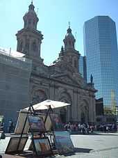
The Cathedral on the central square (Plaza de Armas) is a sight that ranks as high as the Palacio de La Moneda, the Presidential Palace. The original building was built between 1784 and 1805, and architect Joaquín Toesca was in charge of its construction. Other buildings surrounding the Plaza de Armas are the Central Post Office Building, which was finished in 1882, and the Palacio de la Real Audiencia de Santiago, built between 1804 and 1807. It houses the Chilean National History Museum, with 12,000 objects that can be exhibited. On the southeast corner of the square stands the green cast-iron Commercial Edwards building, which was built in 1893. East of that is the colonial building of the Casa Colorada (1769), which houses the Museum of Santiago. Close by is the Municipal Theatre of Santiago, which was built in 1857 by the French architect Brunet of Edward Baines. It was badly damaged by an earthquake in 1906. Not far from the theatre is the Subercaseaux Mansion and the National Library, one of the largest libraries of South America.
The Former National Congress Building, the Justice Palace, and the Royal Customs Palace (Palacio de la Real Aduana de Santiago) are located close to each other. The latter houses the Museum of pre-Columbian art. A fire destroyed the building of the Congress in 1895, which was then rebuilt in a neoclassical style and reopened in 1901. The Congress was deposed under the military dictatorship of Augusto Pinochet (1973–1989), and after the dictatorship was newly constituted on 11 March 1990, in Valparaíso.
The building of the Justice Palace (Palacio de Tribunales) is located on the south side of the Montt Square. It was designed by the architect Emilio Doyére and built between 1907 and 1926. The building is home to the Supreme Court of Chile. The panel of 21 judges is the highest judicial power in Chile. The building is also headquarters of the Court of Appeals of Santiago.
Bandera street leads toward the building of the Santiago Stock Exchange (the Bolsa de Comercio), completed in 1917, the Club de la Unión (opened in 1925), the Universidad de Chile (1872), and toward the oldest churchhouse in the city, the San Francisco Church (constructed between 1586 and 1628), with its Marian statue of the Virgen del Socorro ("Our Lady of Help"), which was brought to Chile by Pedro de Valdivia. North of the Plaza de Armas ("Square of Arms", where the colonial militia was mustered) are the Paseo Puente, the Santo Domingo Church (1771), and the Central Market (Mercado Central), an ornamental iron building. Also in downtown Santiago is the Torre Entel, a 127.4-meter-high television tower with observation deck completed in 1974; the tower serves as a communication center for the communications company, ENTEL Chile.
The Costanera Center was completed in 2009, and includes housing, shopping, and entertainment venues. The project, with a total area of 600,000 square meters, includes the 300-meter high Gran Torre Santiago (South America's tallest building) and other commercial buildings. The four office towers are served by highway and subway connections.[49]
-

Municipal Theatre of Santiago
-

Palacio de La Moneda
-

Contemporary Art Museum of Santiago
-

Biblioteca Nacional de Chile
-

Former Congress Building

Music
There are two symphonic orchestras:
- Orquesta Filarmónica de Santiago ("Philharmonic Orchestra of Santiago"), which performs in the Teatro Municipal (Municipal Theatre of Santiago) and * Orquesta Sinfónica de Chile ("Symphonic Orchestra of Chile"), dependent of the Universidad de Chile, performs in its theater.
There are a number of jazz establishments, some of them, including "El Perseguidor", "Thelonious", and "Le Fournil Jazz Club", are located in Bellavista, one of Santiago's "hippest" neighborhoods, though "Club de Jazz de Santiago", the oldest and most traditional one, is in Ñuñoa.[50] Annual festivals featured in Santiago include Lollapalooza and the Maquinaria festival.
Newspapers
The most widely circulated newspapers in Chile are published by El Mercurio and Copesa and have earned more than the 91% of revenues generated in printed advertising in Chile.[51]
Some newspapers available in Santiago are:
Sports
Santiago is home to some of Chile's most successful football clubs. Colo-Colo, founded on 19 April 1925, has a long tradition, and has played continuously in the highest league since the establishment of the first Chilean league in 1933. Wins include 29 national titles, 10 Copa Chile successes, and champions of the Copa Libertadores tournament in 1991, the only Chilean team to have won this tournament. The club hosts its home games in the Estadio Monumental in the commune of Macul.
Universidad de Chile has 16 national titles and 3 Copa Chile wins. In 2011 they were champions of Copa Sudamericana, the only Chilean team to have won this tournament. The club was founded on 24 May 1927, under the name Club Deportivo Universitario as a union of Club Náutico and Federación Universitaria. The founders were students of the University of Chile. In 1980, the organization separated from the University of Chile and the club is now completely independent. The team plays its home games in the Estadio Nacional de Chile in the commune of Ñuñoa.

Club Deportivo Universidad Católica (UC) was founded on 21 April 1937. It consists of fourteen different departments. This team plays its home games in Estadio San Carlos de Apoquindo. Universidad Católica has 10 national titles, making it the third most successful football club in the country. It has played the Copa Libertadores more than 20 times, reaching the final in 1993, losing to São Paulo FC.
Several other football clubs are based in Santiago, including Unión Española, Audax Italiano, Palestino, Santiago Morning, and Magallanes. In addition to football, several sports are played in the city, tennis and basketball being the main ones. The Club Hípico de Santiago and the Hipódromo Chile are the two horseracing tracks in the city.
Recreation
There is an extensive network of bicycle trails in the city, especially in the Providencia comuna. The longest section is the Americo Vespuccio road, which contains a very wide dirt path with many trees through the center of a street used by motorists on both sides. The next longest path is along the Mapocho River along avenida Andrés Bello. Many people use folding bicycles to commute to work.[52]
The city's main parks are:
- Cerro San Cristóbal – San Cristóbal Hill, which includes the Santiago Metropolitan Park Zoo
- Parque O'Higgins – O'Higgins Park
- Parque Forestal – Forestal Park, park located at the city center alongside Mapocho river
- Cerro Santa Lucía – Santa Lucía Hill
- Parque Araucano in Las Condes adjacent to the Parque Arauco shopping mall contains 30 hectares of gardens. It is closed for maintenance on Mondays.
- Parque Inés de Suarez, Providencia
- Parque Padre Hurtado (a.k.a. Parque Intercomunal)
There are ski resorts to the east of the city (Valle Nevado, La Parva, El Colorado) and wineries in the plains west of the city.
Cultural venues include:
- Museo de Bellas Artes – Fine Arts Museum
- Barrio Bellavista, cultural and bohemian neighborhood
- Central Station, railway station designed by Gustave Eiffel
- Víctor Jara Stadium
- Ex National Congress
- Plaza de Armas, central square
- Palacio de La Moneda, government palace
- Teatro Municipal (Municipal Theatre of Santiago),the principal opera house of the country. The main sport venues are Estadio Nacional (site of the 1962 World Cup final), Estadio Monumental David Arellano, Estadio Santa Laura, and Estadio San Carlos de Apoquindo.
Religion
As in most of Chile, the majority of the population of Santiago is Catholic. According to the National Census, carried out in 2002 by the National Statistics Bureau (INE), in the Santiago Metropolitan Region, 3,129,249 people 15 and older identified themselves as Catholics, equivalent to 68.7% of the total population, while 595,173 (13.1%) described themselves as Evangelical Protestants. Around 1.2% of the population declared themselves as being Jehovah's Witnesses, while 0.9% identified themselves as Latter-day Saints (Mormons), 0.25% as Jewish, 0.11% as Orthodox and 0.03% as Muslim. Approximately 10.4% of the population of the Metropolitan Region stated that they were atheist or agnostic, while 5.4% declared that they followed other religions.[53] In 2010 construction was initiated on the continental Bahá'í House of Worship for South America in the commune of Peñalolen.
Education
The city is home to numerous universities, colleges, research institutions and libraries.
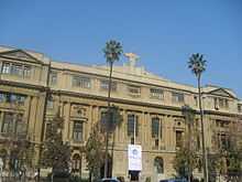
The largest university and one of the oldest in the Americas is Universidad de Chile. The roots of the University date back to the year 1622, as on 19 August the first university in Chile under the name of Santo Tomás de Aquino was founded. On 28 July 1738, it was named the Real Universidad de San Felipe in honor of King Philip V of Spain. In the vernacular, it is also known as Casa de Bello (Spanish: House of Bello – after their first Rector, Andrés Bello). On 17 April 1839, after Chile's independence from the Kingdom of Spain, it was renamed the Universidad de Chile, and reopened on 17 September 1843.
The Pontificia Universidad Católica de Chile (PUC) was founded in June 1888. On 11 February 1930 it was declared a university by a decree of Pope Pius XI. It received recognition by the Chilean government as an appointed Pontifical University in 1931. Joaquín Larraín Gandarillas (1822–1897), Archbishop of Anazarba, was the founder and first rector of the PUC. The PUC is a modern university; the campus of San Joaquin has a number of contemporary buildings and offers many parks and sports facilities. Several courses are conducted in English. The current president, Sebastián Piñera, minister Ricardo Raineri, and minister Hernán de Solminihac all attended PUC as students and worked in PUC as professors. In the 2010 admission process, approximately 48% of the students who achieved the best score in the Prueba de Selección Universitaria matriculated in the UC.[54]
Higher education
Traditional

- Universidad de Chile (U or UCH)
- Pontificia Universidad Católica de Chile (PUC)
- Universidad de Santiago de Chile (USACH)
- Universidad Metropolitana de Ciencias de la Educación (UMCE)
- Universidad Tecnológica Metropolitana (UTEM)
- Universidad Técnica Federico Santa María (UTFSM)
Non-traditional
- Universidad Adolfo Ibáñez (UAI)
- Universidad del Desarrollo (UDD)
- Universidad Diego Portales (UDP)
- Universidad Alberto Hurtado (UAH)
- Universidad Central de Chile (Ucen)
- Universidad Nacional Andrés Bello (Unab)
- Universidad Academia de Humanismo Cristiano (UAHC)
- Universidad de Ciencias de la Informática (UCINF)
- Universidad Mayor (UM)
- Universidad Finis Terrae
- Universidad de Los Andes
- Universidad Gabriela Mistral (UGM)
- Universidad del Pacífico
- Universidad de las Américas
- Universidad de Artes, Ciencias y Comunicación (UNIACC)
- Universidad San Sebastián (USS)
- Universidad Bolivariana
Other
- Ruprecht Karls University of Heidelberg's Postgraduierten- und Weiterbildungszentrum der Universität Heidelberg in Santiago
- David Rockefeller Center for Latin American Studies (DRCLAS) Regional Office in Santiago
- Stanford Faculty in Santiago
International relations
Twin towns and sister cities
Santiago is twinned with:
|
Partner city
Gallery
-

Club de La Unión
-
Santiago
-

Quartermaster Metropolitan, seat of government of Santiago Metropolitan Region
-

Façade of the Santiago Stock Exchange
-
Paseo Bulnes, downtown Santiago
-

Paseo Ahumada, downtown Santiago
-

Entel Tower

References
- ↑ Luis de Cartagena (1861 – v.). Actas del Cabildo de Santiago de 1541 a 1557th In Colección de Historiador de Chile y de documentos relativos a la historia nacional. Tomo 1st. Santiago de Chile: Impr. del Ferrocarril. p. 67.
- ↑ "Llega Pedro de Valdivia al valle del Mapocho". Icarito.
- ↑ De Ramón, Armando (2000). Santiago de Chile (1541–1991). Historia de una sociedad urbana. Santiago de Chile: Editorial Sudamericana. p. 15f. ISBN 978-956-262-118-2. Retrieved 19 March 2009.
- ↑ De Ramón, Armando, 2000, p. 17
- ↑ 5.0 5.1 5.2 5.3 5.4 5.5 A history of Chile. Books.google.com. 16 August 2007. Retrieved 17 April 2010.
- ↑ "San Francisco Church and Convent," UNESCO World Heritage Center. Retrieved 1 February 2011.
- ↑ Ayarza Elorza, Hernán. "Historia in engineering: the embankments Mapocho" (PDF). Engineering Magazine. Retrieved 16 December 2007.
- ↑ Martín (29 May 2007). "Past, present, and future images of a "green space" in the metropolitan area of Santiago". Revista Urbanismo, Nº3.
- ↑ 9.0 9.1 Politics and urban growth in Santiago, Chile, 1891–1941 By Richard J. Walter. Books.google.com. 3 January 2005. ISBN 9780804749824. Retrieved 17 April 2010.
- ↑ 10.0 10.1 10.2 10.3 "Santiago de Chile, ¿ejemplo de una reestructuración capitalista global?". Scielo.cl. 6 January 1990. Retrieved 17 April 2010.
- ↑ Soto, Alonso (27 February 2010). "Massive earthquake kills 82 in Chile". http://www.reuters.com. Retrieved 27 February 2010.
- ↑ Pontificia Universidad Católica de Chile (2001). "Contaminación atmosférica. Casos de estudio: Santiago de Chile". Retrieved 24 June 2007.
- ↑ Peaklist (2007). "Argentina and Chile Central, Ultra-Prominences". Retrieved 24 June 2007.
- ↑ 14.0 14.1 René Garreaud-Salazar Impacto en la variabilidad de la línea de nieve en crecidas invernales en cuencas pluvio-nivales de Chile central. (Spanish) Sociedad Chilena de Ingeniería Hidráulica, XI Congreso Chileno. Retrieved 20 January 2012.
- ↑ 15.0 15.1 "Estadisca Climatologica Tomo I" (in Spanish). Dirección General de Aeronáutica Civil. March 2001. pp. 404–427. Retrieved September 6, 2013.
- ↑ Cappelen, John; Jensen, Jens. "Chile — Santiago". Climate Data for Selected Stations (1931–1960) (in Danish). Danish Meteorological Institute. p. 68. Retrieved March 10, 2013.
- ↑ Pamela Morales. "Chilean University Finds Santiago Pollution Has Doubled". The Santiago Times. Retrieved 27 January 2010.
- ↑ Valdez, Ana; et al. (2012). "Elemental concentrations of ambient particles and cause specific mortality in Santiago, Chile: a time series study.". Environmental Health 11 (1): 82.
- ↑ Revista Ecoamérica. "Cruzada ambiental por el Mapocho limpio" (in Spanish). Retrieved 11 February 2008. "permitirá pasar del 68 al 81% en el tratamiento de las aguas servidas"
- ↑ El Mercurio. "Región Metropolitana saneará el 100% de aguas servidas al 2010" (in Spanish). Fundación Terram. Retrieved 11 February 2008.
- ↑ Comisión Regional Metropolitana del Medio Ambiente. "Agua, Recurso Escaso y Vital" (in Spanish). Archived from the original on 28 July 2008. Retrieved 2 November 2008. "se calcula que sólo el 77% de las industrias del país cumple con la norma de RILES existente"
- ↑ "Mapocho urbano limpio: El río soñado" (PDF). Archived from the original on 25 June 2008. Retrieved 2 November 2008. "Proyecto Mapocho Urbano Limpio"
- ↑ Fundación Futuro. "Proyecto Mapocho" (in Spanish).
- ↑ "Informe anual de coberturas de servicios sanitarios" (PDF). Superintendencia de servicios sanitarios. Archived from the original on December 2012. Retrieved 20 December 2013.
- ↑ Comisión Regional Metropolitana del Medio Ambiente. "Ruidos molestos en Santiago" (in Spanish). Archived from the original on 17 January 2008. Retrieved 11 February 2008. "cerca de un 70% de la población santiaguina está expuesta a serias interferencias de su sueño por ruido que excede 65 dB"
- ↑ "Cipma.cl" (PDF). Retrieved 17 April 2010.
- ↑ "Bio.puc.cl". Retrieved 17 April 2010.
- ↑ Pedro Oyola. "the role of monitoring in air quality management".
- ↑ "Conoma.cl". Conama.cl. 14 May 2008. Retrieved 17 April 2010.
- ↑ Martínez, Adrián. "Chile: Economy, income inequality growing". Infosurhoy.com. Retrieved 4 August 2011.
- ↑ Agostini, Claudio A.; Brown (June 2007). Revista de Analisis Economico (in Spanish) 22 (1): 3–33 http://papers.ssrn.com/sol3/Delivery.cfm/SSRN_ID1260253_code1066993.pdf?abstractid=1260253&mirid=1
|url=missing title (help). Retrieved 4 August 2011. - ↑ Chile: It’s a Dog’s World (Retrieved 4 August 2011)
- ↑ The strays of Santiago 17 June 2009 (Retrieved 4 August 2011)
- ↑ First Case of Human Rabies in Chile Caused by an Insectivorous Bat Virus Variant
- ↑ 35.0 35.1 35.2 Se consideran en total las comunas de la Provincia de Santiago, más Padre Hurtado, Pirque, Puente Alto y San Bernardo. Estas cifras no son equivalentes a la de la ciudad de Santiago pues excluyen ciertas áreas fuera de dichas comunas e incluyen algunas zonas rurales; sin embargo, representa a un 95,4% de la población total del área metropolitana.
- ↑ INE. "Chile, proyecciones de población al 30 de junio (1990–2020): Región Metropolitana de Santiago" (XLS). Retrieved 23 December 2007.
- ↑ "Santiago.cl". Santiago.cl. Retrieved 17 April 2010.
- ↑ "Reuters.com". In.reuters.com. 29 January 2009. Retrieved 17 April 2010.
- ↑ "La Segunda". La Segunda. Retrieved 6 June 2011.
- ↑ "Why You Should Move to Santiago, Chile". BrophyWorld. Retrieved 23 November 2011.
- ↑ "Estadisticas de trafico de pasajeros". SCL--Aeropuerto de Santiago. Aeropuerto de Santiago. Retrieved 22 December 2013.
- ↑ http://www.efe.cl/link.cgi/668
- ↑ "Piñera anuncia construcción de dos nuevas Líneas del Metro para 2014 | Nacional". La Tercera. 1 January 1990. Retrieved 13 March 2011.
- ↑ "Railway-technology.com". Railway-technology.com. Retrieved 17 April 2010.
- ↑ 45.0 45.1 "Metrosantiago.cl". Metrosantiago.cl. Retrieved 17 April 2010.
- ↑ "Website Metroten Santiago". Tmsa.cl. Retrieved 17 April 2010.
- ↑ Pontificia Universidad Católica de Chile (2004), Boletín de Políticas Públicas: Una autoridad metropolitana para Santiago
- ↑ Alexander Galetovic; Pablo Jordán (Summer 2008). "Santiago: ¿Dónde estamos?, ¿Hacia dónde vamos?" (PDF) (in Spanish). Estudios Públicos.
- ↑ Emporis: Gran Torre Costanera
- ↑ Chile’s Best Known Bohemian Outpost – Bellavista – Bursting With New Activity, Santiago Times
- ↑ Torta para dos ¿Hasta cuando?, elciudadano.cl
- ↑ Bicycles in Santiago, New York, and Tokyo | Brophy World
- ↑ "INE, Chile, 2002 Census". Ine.cl. Retrieved 17 April 2010.
- ↑ "Los Mejores Puntajes Prefieren la UC – DSRD – PUC". DSRD. Retrieved 13 March 2011.
- ↑ "Pesquisa de Legislação Municipal - No 14471" [Research Municipal Legislation - No 14471]. Prefeitura da Cidade de São Paulo [Municipality of the City of São Paulo] (in Portuguese). Archived from the original on 2011-10-18. Retrieved 2013-08-23.
- ↑ Lei Municipal de São Paulo 14471 de 2007 WikiSource (Portuguese)
- ↑ "Kardeş Kentleri Listesi ve 5 Mayıs Avrupa Günü Kutlaması [via WaybackMachine.com]" (in Turkish). Ankara Büyükşehir Belediyesi - Tüm Hakları Saklıdır. Archived from the original on 14 January 2009. Retrieved 2013-07-21.
- ↑ "Twin cities of Riga". Riga City Council. Retrieved 27 July 2009.
- ↑ "Sister Cities of Manila". © 2008–2009 City Government of Manila. Retrieved 2 September 2009.
External links
| Wikimedia Commons has media related to Santiago de Chile. |
- Santiago Tourist – an independent travel guide
| ||||||||||||

| |||||
| |||||