Santana, Amapá
From Wikipedia, the free encyclopedia
| Santana | |||
|---|---|---|---|
| Municipality | |||
| The Municipality of Santana | |||
 | |||
| |||
 | |||
| Coordinates: 00°02′06″S 51°51′10″W / 0.03500°S 51.85278°WCoordinates: 00°02′06″S 51°51′10″W / 0.03500°S 51.85278°W | |||
| Country |
| ||
| Region | North | ||
| State |
| ||
| Founded | February 4, 1758 | ||
| Government | |||
| • Mayor | José Antonio Nogueira de Sousa (PT) | ||
| Area | |||
| • Total | 1,577.517 km2 (609.083 sq mi) | ||
| Elevation | 5 m (15 ft) | ||
| Population (2012) | |||
| • Total | 104,407 | ||
| • Density | 66/km2 (170/sq mi) | ||
| [1] | |||
| Time zone | UTC-3 (UTC-3) | ||
| HDI (2000) | 0.742 – medium[2] | ||
| Website | laranjaldojari.ap.gov.br | ||
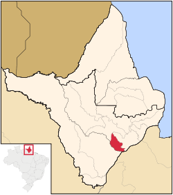
Santana is a municipality located in the southeast of the state of Amapá in Brazil. Its population is 98,600 and its area is 1,578 km², which makes it the smallest municipality of Amapá. Santana is a suburb of Macapá, the state capital. Its location is nearly on the equator. The planet's second longest river, the Amazon is to the south.
Sports
Independente Esporte Clube and Santana Esporte Clube are the football clubs based in the city of Santana.
Neighboring municipalities
- Macapá, north and east
- Mazagão, southwest
- Porto Grande, northwest
References
- ↑ "2012 Populational Estimate". Censo Populacional 2012. Instituto Brasileiro de Geografia e Estatística (IBGE). July 2012. Retrieved August 31, 2012.
- ↑ UNDP
External links
- Official website (Portuguese)
- (Portuguese) http://www.citybrazil.com.br/ap/portogrande/ (Portuguese)
| ||||||||||||||||||||
This article is issued from Wikipedia. The text is available under the Creative Commons Attribution/Share Alike; additional terms may apply for the media files.


