Santa Isabel Island
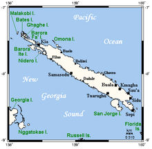 Map of Santa Isabel, neighboring islands, and towns and villages | |
 | |
| Geography | |
|---|---|
| Location | Pacific Ocean |
| Archipelago | Solomon Islands |
| Area | 2,999 km2 (1,158 sq mi) |
| Highest elevation |
1,220 m (4,000 ft) [1] |
| Highest point | Mount Sasari |
| Country | |
|
Solomon Islands | |
| Province | Isabel Province |
| Largest city | Buala |

Location and geographic data
Choiseul lies to the north-west, Malaita to the south-east. The Pacific Ocean lies to the north, and Guadalcanal (Isatabu) to the south.
The highest point in Santa Isabel is Mount Sasari, 1220 meters (3675 ft). River Marutho runs down that mountain into the ocean at Hofi. Almost all the rivers or streams run down that center point except for those at the other tip of the Island, Katova side.
The administrative centre is Buala, where the airport is as well. See List of airports in the Solomon Islands. Another important village on the island is Samasodu.
History
The first European contact to the Solomon Islands was made here, by the Spanish explorer Álvaro de Mendaña on 7 February 1568. It was charted as Santa Isabel de la Estrella (St. Elizabeth of the Star of Bethlehem in Spanish). A settlement was established here by the Spaniards, and a small boat (known in the accounts as the brigantine) built to survey and chart the surrounding sea and islands. These local explorations led by Maestre de Campo Pedro Ortega Valencia and Alférez Hernando Enríquez resulted in the discoveries of the islands of Malaita, Guadalcanal, Savo, Vangunu, Choiseul, Makira, Ulawa, Malaupaina, Malaulalo, Ali'ite, and Ugi Island.[2][3] The Spanish immediately came into contact with Solomon Islanders and at first the relationship was cordial. However, the Spanish expedition's need for fresh food and water quickly led to tension and conflict, the Solomon Islanders’ subsistence economy being unable to provide continuous supplies to the Spanish.[4]
Having found no gold and little food, and beset by attacks and sickness, the Spanish colonists shifted their colony to the site of today's Honiara on Guadalcanal. Their colony, however, would die out.
Santa Isabel islanders suffered attacks from raiding headhunters in the nineteenth century. They embraced Christianity around the turn of the 20th century.
In May 27, 2011, 17 men were arrested for burning down the houses in Ulubea riverside settlement, 33 houses in all, as a result of a property dispute.[5][6] The number was later expanded to 31.[7]
Languages
The population of Santa Isabel speak as many as eight languages in addition to English and Solomon Islands Pijin.
- Blablanga language
- Bughotu language
- Cheke Holo language formerly called Marine or Maringe
- Gao language
- Kokota language
- Laghu language (extinct)
- Zabana language
- Zazao language
Further reading
- Geoffrey M. White, Identity through History; Living Stories in a Solomon Islands Society, Cambridge Studies in Social and Cultural Anthropology Series (No. 83) ISBN 978-0-521-40172-2
- Informal learning strategies in the Solomon Islands
Notes and references
- ↑ Hammond World Travel Atlas. Union, N.J.: Hammond World Atlas Corporation, c. 2004-2005. ISBN 0-8437-1982-6. Page 245
- ↑ Sharp, Andrew The discovery of the Pacific Islands Oxford, 1960, pp.48.
- ↑ Brand, Donald D. The Pacific Basin: A History of its Geographical Explorations The American Geographical Society, New York, 1967, p.133.
- ↑ Spate, O.H.K. (1979) The Spanish Lake. p.121, (Second Edition 2004) Australian National University, p.124
- ↑ "Police respond to arson attack in Isabel Province". Solomon Star. 31 May 2011. Retrieved 18 January 2013.
- ↑ Buchanan, Assumpta (7 June 2011). "Men remanded for Isabel arson". Solomon Star. Retrieved 18 January 2013.
- ↑ Buchanan, Assumpta (21 July 2011). "Isabel arson case, August 1". Solomon Star. Retrieved 18 January 2013.
Coordinates: 8°01′50″S 159°10′34″E / 8.03056°S 159.17611°E