Santa Elena Municipality
| Santa Elena | |
|---|---|
| Municipality | |
 | |
 | |
 Santa Elena | |
| Coordinates: 20°21′N 89°46′W / 20.350°N 89.767°WCoordinates: 20°21′N 89°46′W / 20.350°N 89.767°W | |
| Country |
|
| State |
|
| Mexico Ind. | 1821 |
| Yucatán Est. | 1824 |
| Municipality Est. | 1918 |
| Government | |
| • Type |
PRI |
| • Municipal President | Eduardo Huchin Kauil[1] |
| Area | |
| • Total | 694.90 km2 (268.30 sq mi) |
| [1] | |
| Elevation | 31 m (102 ft) |
| Population (2005 [2][3]) | |
| • Total | 3,617 |
| • Density | 5.2/km2 (13/sq mi) |
| Time zone | Central Standard Time (UTC-6) |
| • Summer (DST) | Central Daylight Time (UTC-5) |
| INEGI Code | 066 |
| Major Airport | Merida (Manuel Crescencio Rejón) International Airport |
| IATA Code | MID |
| ICAO Code | MMMD |
| Website | Official Website |
| Municipalities of Yucatán | |
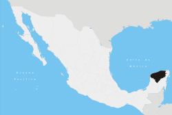
The Municipality of Santa Elena is one of the 106 municipalities in Yucatán state, Mexico. Its municipal seat is located in the City of Santa Elena. The municipality borders to the north the municipality of Muna, to the south Oxkutzcab and east Ticul, and to the west Halacho.[1]
Communities
The municipality has primarily two communities. Their populations is as follows:
| Community | Population[4] |
|---|---|
| Entire Municipality | 3,617 |
| Santa Elena | 3,252 |
| San Simón | 357 |
| Other | 8 |
History
Already inhabited during the Classic Maya period (600-1000 A.C.), the originally named Nohcacab was during the Colony an encomienda, that is a tribute-paying small community with an ethnically mixed population which included Spanish people, criollos, mestizos and mulattos.[5] In the early 1840s the explorer John Lloyd Stephens used this small community as a base from which he and his companions departed to explore the Puuc area: thanks to this fact we still have detailed accounts about the people of Nohcacab and their culture, as well as drawings showing how these visitors perceived the village at that time.[6]
Nohcacab was attacked, and even burned down, several times: the second one in 1849, during the so-called Caste War; after this, the village was devastated and most of the Spanish and criollo population emigrated into Merida.[7] It is very likely that around that time the village was officially renamed as Santa Elena.
It wasn't until 1865, with the arrival of approximately 300 German colonists, who settled there to form the Villa Carlota farming colony under the initiative of Emperor Maximilian I of Mexico, that the village started to see some improvements.[8] Although this farming colony collapsed in 1867, several German families remained in the village[9]
Climate
| Climate data for Santa Elena | |||||||||||||
|---|---|---|---|---|---|---|---|---|---|---|---|---|---|
| Month | Jan | Feb | Mar | Apr | May | Jun | Jul | Aug | Sep | Oct | Nov | Dec | Year |
| Average high °C (°F) | 29.6 (85.3) |
31.5 (88.7) |
34 (93) |
35.9 (96.6) |
37 (98.6) |
34.8 (94.6) |
34.3 (93.7) |
34 (93.2) |
33.1 (91.6) |
31.7 (89.1) |
30.4 (86.7) |
29.2 (84.6) |
32.96 (91.31) |
| Average low °C (°F) | 13.2 (55.8) |
14 (57.2) |
16 (60.8) |
18 (64.4) |
19.9 (67.8) |
20.5 (68.9) |
19.5 (67.1) |
19.6 (67.3) |
19.8 (67.6) |
18.3 (64.9) |
16.2 (61.2) |
14.4 (57.9) |
17.45 (63.41) |
| Precipitation cm (inches) | 3 (1) |
2.8 (1.1) |
3 (1.2) |
4.8 (1.9) |
7.4 (2.9) |
14.5 (5.7) |
13.2 (5.2) |
15.7 (6.2) |
19.3 (7.6) |
11.9 (4.7) |
4.1 (1.6) |
2.8 (1.1) |
102.5 (40.2) |
| Source: Weatherbase [10] | |||||||||||||
Landmarks
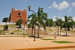
Architectural
San Mateo Church.[1]
Archaeological
A number of archaeological sites including: Uxmal, Kabah, Nohpat, Xcoh and Mul chic[1] (Puuc Region).
Local Festivals
January 10 to 24 the feast in honor of Santo Cristo del Amor.[1]
May 17 the festival in honor of Santos Reyes of San Mateo.[1]
References
- ↑ 1.0 1.1 1.2 1.3 1.4 1.5 1.6 "Nuestros municipios - Santa Elena". Retrieved 2009-11-12.
- ↑ "Encyclopedia of the Municipalities of Mexico: Yucatan". Retrieved 2009-11-01.
- ↑ Census Results by Locality, 2005 INEGI.
- ↑ Census Population Results, 2005 INEGI.
- ↑ Güemez Pineda, Arturo (1997): "The Rebellion of Nohcacab: Unpublished Preface to the Caste War, in: Saastun. Maya Culture Review, no. 2, pp. 51-79, here p. 54. See also: de Arrigunaga y Peón, Joaquín (1982): Demography and Parish Affairs in Yucatan, 1797-1891. Eugene: University of Oregon Anthropological Papers, pp. 254-255
- ↑ See Stephens, John Lloyd (1963), Incidents of Travel in Yucatan, vol. 1, pp. 202, 301
- ↑ Güemez Pineda 1997, op. cit.
- ↑ Durán-Merk, Alma (2007): Identifying Villa Carlota: German Settlements in Yucatán, México, During the Second Mexican Empire, 1864-1867, Augsburg: Universität Augsburg
- ↑ Recent Findings about the Colonization Policy of the Second Mexican Empire, Paper presented at the 11th Deutschsprachige Mesoamerikanisten Tagung in Hildesheim, Germany (26-27th January, 2008). http://opus.bibliothek.uni-augsburg.de/volltexte/2008/1320/pdf/Duran_Merk_Selected_German_Migration.pdf. See also: Medina Un, Martha (2001): Migración alemana en Santa Elena, la antigua Nohcacab, in: Revista INA'J , no. 1, pp. 28-31
- ↑ "Weatherbase: Historical Weather for Santa Elena, Yucatán". Weatherbase. 2011. Retrieved on November 24, 2011.
| |||||||||||||||||||||||