Sandgerði
From Wikipedia, the free encyclopedia
| Sandgerði | ||
|---|---|---|
| Town and Municipality | ||
| ||
 | ||
 Sandgerði | ||
| Coordinates: 64°03′N 22°42′W / 64.050°N 22.700°W | ||
| Country |
| |
| Constituency[1] | Suðurkjördæmi | |
| Region[2] | Suðurnes[3] | |
| County | Gullbringusýsla | |
| Municipality | Sandgerðisbær | |
| Area | ||
| • Total | 62 km2 (24 sq mi) | |
| Population (2011) | ||
| • Total | 1,683 | |
| • Density | 27.79/km2 (72.0/sq mi) | |
| Website | Official website | |
| Postal Code: 245 | ||
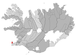
Sandgerðisbær (formerly Miðneshreppur) is an Icelandic municipality located in southwestern Iceland on the Reykjanes peninsula.
The land area of Sandgerðisbær is 62 km² (23.9 sq mi) and covers the entire western coast of Miðnes (Rosmhvalanes) north from Garðskagi to Ósabotnar in the south.
Overview
Inland the land area of Sandgerðisbær stretches into the international airport at Keflavíkurflugvöllur with the air terminal within the municipal boundaries. As of January 2011, Sandgerðisbær had a population of 1,683 and was the 26th most populated municipality in Iceland.[4]
Sports
Reynir football club play in Iceland's third tier.
References
External links
![]() Media related to Sandgerði at Wikimedia Commons
Media related to Sandgerði at Wikimedia Commons
| |||||||||||
Coordinates: 64°03′11″N 22°42′15″W / 64.05306°N 22.70417°W
This article is issued from Wikipedia. The text is available under the Creative Commons Attribution/Share Alike; additional terms may apply for the media files.

