Samphrey
| Samphrey | |
|---|---|
| Location | |
 Samphrey | |
| OS grid reference | HU467762 |
| Names | |
| Norse name | Sandfriðarey |
| Meaning of name | Old Norse for Sand |
| Area and summit | |
| Area | 66 ha (0.25 sq mi) |
| Area rank | 178=[1] |
| Highest elevation | 44 m (144 ft) |
| Population | |
| Population | 0 |
| Groupings | |
| Island group | Shetland |
| Local Authority | Shetland Islands |
| References | [2][3][4][5] |


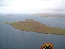
Samphrey (Old Norse: Sandfriðarey) is an uninhabited island in the Shetland Islands, Scotland. One of Fair Isle's old names is "Friðarey"[5] which is of similar origin.
It is situated in the southern end of Yell Sound, between the Mainland, Shetland at Mossbank and the island of Yell. On the O-S 1:50,000 map[4] it covers an area of about 66 ha (including the once separate island of Bunglan}.[3][6] It is in the parish of Delting.
To the north west of Samphrey is Bunglan, which was once an island in its own right, but has become silted up by two tombolos, which now connect it to Samphrey. There is a small loch between Bunglan and Samphrey proper, which can just about be seen on the aerial picture.
Blaeu calls the island "Sancterre" (Holy Land) in the 17th century, lending the island another intriguing etymology.
References
- ↑ Area and population ranks: there are c. 300 islands >20ha in extent and 93 permanently inhabited islands were listed in the 2011 census.
- ↑ 2001 UK Census per List of islands of Scotland
- ↑ 3.0 3.1 Haswell-Smith, Hamish (2004). The Scottish Islands. Edinburgh: Canongate. ISBN 978-1-84195-454-7.
- ↑ 4.0 4.1 Ordnance Survey
- ↑ 5.0 5.1 Anderson, Joseph (Ed.) (1893) Orkneyinga Saga. Translated by Jón A. Hjaltalin & Gilbert Goudie. Edinburgh. James Thin and Mercat Press (1990 reprint). ISBN 0-901824-25-9
- ↑ "Samphrey". Gazetteer for Scotland. Retrieved 18 December 2009.
| ||||||||
Coordinates: 60°28′N 1°9′W / 60.467°N 1.150°W