Salobreña
| Salobreña | |||
|---|---|---|---|
| Municipality | |||
 | |||
| |||
 | |||
 Salobreña | |||
| Coordinates: 36°44′N 3°35′W / 36.733°N 3.583°WCoordinates: 36°44′N 3°35′W / 36.733°N 3.583°W | |||
| Country |
| ||
| Autonomous community |
| ||
| Province | Granada | ||
| Comarca | Costa Tropical | ||
| Judicial district | Motril | ||
| • Marquis de Salobreña | (PP) | ||
| Area | |||
| • Total | 34.91 km2 (13.48 sq mi) | ||
| Elevation | 95 m (312 ft) | ||
| Highest elevation | 160 m (520 ft) | ||
| Lowest elevation | 0 m (0 ft) | ||
| Population (2009) | |||
| • Total | 12,747 | ||
| • Density | 370/km2 (950/sq mi) | ||
| Demonym | Salobreñero, -ra | ||
| Time zone | CET (UTC+1) | ||
| • Summer (DST) | CEST (UTC+2) | ||
| Postal code |
18680 (Salobreña y La Caleta-Guardia), 18610 (Lobres) | ||
| Official language(s) | Spanish | ||
| Website | Official website | ||

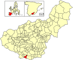
Salobreña (pronounced: [saloˈβɾeɲa]) is a town on the Costa Tropical in Granada, Spain. It claims a history stretching back 6,000 years.[citation needed]
There are two main parts of Salobreña; The first is The Old Town which sits atop a rocky prominence and is a cluster of whitewashed houses and quirky steep narrow streets leading up to a 10th-century Moorish castle. This is called 'El Castillo De Salobreña' which is one of its main tourist attractions. The second part of Salobreña is new developments which spread from the bottom of The Old Town right to the Beach. The whole town is almost surrounded by sugarcane fields on each side along the coast and further inland.
Another tourist attraction in Salobreña is 'El Peñon' (The Rock) which divides two of Salobreña's five beaches and juts out between Playa La Guardia and Playa de la Charca/Solamar and into the sea.
The last remaining cane sugar factory in Europe is located along the coast just west of the village of La Caleta de Salobreña.[citation needed]
| Wikimedia Commons has media related to Salobreña. |
.svg.png)
.svg.png)