Salme ships
The Salme ships are two pre-Viking era clinker-built ships that were discovered in 2008 near Salme village in Saaremaa, Estonia. Both ships were used for ship burial around AD 750 and contained the remains of more than 40 warriors killed in battle, as well as numerous weapons and other artifacts.
Discovery

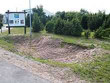
The ships were discovered in 2008 during earth removal for infrastructure construction. An archaeological expedition has been working on site since 2008. It is possible that at least one more ship is yet to be discovered during future excavations.
Location
The ships were located near the ancient coastline, about 1.5 m above water level. The location is 230 m from modern coastline and 4 meters above modern water level.[1]
Ships
Both Salme ships are clinker-built. One of the ships is 11.5 m long and 2 m wide, the second one more than 17 m long and 3 m wide.
Human remains
Skeletal remains belonging to at least 42 individuals were discovered in the two ships.[2] Most of them belonged to 30–40 years old males who had been killed in battle.[3][4] The smaller ship contained the skeletal remains of 7 individuals. There were at least 36 individuals buried in four layers in the large ship.[5]
Grave goods

Fragments of more than 40 swords of various types, remains of shields, spearheads and dozens of arrowheads were found in the burial. Most of them had been deliberately deformed to discourage grave robbery.
Smaller objects included one small socketed axe, knives, whetstones, a bone comb with ornaments, a bear-claw necklace, and hundreds gaming pieces made of whale bone and antler with six dice.
The skeletal remains of two ritually sacrificed dogs as well as hawks used for falconry were found in the burial.
Interpretation
According to an early interpretation offered by Jüri Peets, the lead archaeologist at the site, the ships and the dead are of Scandinavian origin. According to the most likely scenario, a war party of Scandinavians attempted to carry out a raid against the Oeselians, but were attacked by Oeselian ships. The sides of the two ships contain numerous embedded arrowheads, some of which are of the three-pointed type used to carry burning materials to set enemy ships aflame. After losing too many oarsmen to the Estonian archers, the raiders pulled their ships aground and tried to defend themselves behind them. It appears that after the battle the Oeselians allowed either the survivors or some other group of Scandinavians to ritually bury their dead. The burial is unusual because the ships were not covered with mounds. The site was eventually forgotten by the local inhabitants after it had become overblown by sand and covered with vegetation.[6]
The original interpretation was called into question after the second, larger, ship was uncovered. It is likely that the human remains in it belonged to individuals of noble birth, as evidenced by the large number of expensive bronze sword-hilts and the complete lack of weaponry associated with commoners. The presence of dogs and hawks used for falconry indicates that the original purpose of the trip to Estonia may have been leisure or diplomacy.[7]
Legendary background
Snorri Sturluson relates in his Ynglinga saga that the Swedish king Ingvar, Östen's son, was a great warrior who often spent time patrolling the shores of his kingdom fighting Danes and Estonian Vikings (Víkingr frá Esthland). King Ingvar finally came to a peace agreement with the Danes and could take care of the Estonian Vikings. He consequently started pillaging in Estonia in retribution, and one summer he arrived at a place called Stein (see also Sveigder). The Estonians (sýslu kind) assembled a great army in the interior and attacked King Ingvar in a great battle. The Estonian forces were too powerful and Ingvar fell and the Swedish forces retreated. Ingvar was buried in a mound at a place called Stone or Hill fort (at Steini) on the shores of Estonia (Aðalsýsla).
References
- ↑ The Salme shipfind blog
- ↑ Marek Strandberg. "Arheoloog: Eesti ala elanikud surid 536. aasta paiku massiliselt nälga". Postimees 17. märts 2013. (Estonian)
- ↑ Scandinavians were defeated in a battle in Saaremaa (Estonian)
- ↑ Salme muinaslaevast leiti haruldane luukamm (fotod). Saarte Hääl, 07-26-2011. (Estonian)
- ↑ Arheoloogia-aasta parimad palad. Postimees, 10-17-2011. (Estonian)
- ↑ Scandinavians were defeated in a battle in Saaremaa (Estonian)
- ↑ Arheoloogia-aasta parimad palad. Postimees, 10-17-2011. (Estonian)
External links
- 22. March 2013, CWA 58, Archaeologists in Estonia have discovered the most extraordinary site: a mass grave comprising two Viking ship burials , world-archaeology.com
- 10. June 2013, The First Vikings/ Two remarkable ships may show that the Viking storm was brewing long before their assault on England and the continent, archaeology.org
| Wikimedia Commons has media related to Salme shipfind. |
| ||||||||||||||||||
Coordinates: 58°10′03″N 22°15′02″E / 58.16750°N 22.25056°E
