Sakri
From Wikipedia, the free encyclopedia
| Sakri साक्री | |
|---|---|
| town | |
 Sakri | |
| Coordinates: 20°59′25″N 74°18′52″E / 20.99028°N 74.31444°ECoordinates: 20°59′25″N 74°18′52″E / 20.99028°N 74.31444°E | |
| Country |
|
| State | Maharashtra |
| District | Dhule |
| Taluka | Sakri |
| Government | |
| • Body | Village panchayat |
| Elevation | 403 m (1,322 ft) |
| Languages | |
| • Official | Marathi |
| Time zone | IST (UTC+5:30) |
| PIN | 424304 |
| Lok Sabha constituency | Nandurbar |
| Vidhan Sabha constituency | Sakri |
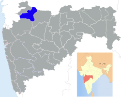
Sakri (Marathi: साक्री) is a small town in the Dhule District of the Nashik division, one of the six divisions of India's Maharashtra state. The town of Sakri is the headquarters for Sakri Taluka.[1] Another Sakri is in Bihar, which is now a railway junction.
The town is located on National Highway 6 running between Hazira (near Surat) in Gujarat to Kolkota, West Bengal.
The people there are mostly Hindu. The languages most spoken in Sakri are Marathi & Ahirani.
Notes
- ↑ "District Administration". Dhule District.
| |||||||||||||||||||||||||
This article is issued from Wikipedia. The text is available under the Creative Commons Attribution/Share Alike; additional terms may apply for the media files.
