Saint-Maurice River
| Saint-Maurice River (Rivière Saint-Maurice) | |
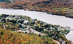 Saint-Maurice River at Grandes-Piles | |
| Country | |
|---|---|
| Province | |
| Region | Mauricie |
| Source | Gouin Reservoir |
| - elevation | 404 m (1,325 ft) |
| - coordinates | 48°21′15″N 74°06′00″W / 48.35417°N 74.10000°W |
| Mouth | Saint Lawrence River |
| - location | Trois-Rivières |
| - coordinates | 46°20′55″N 72°31′40″W / 46.34861°N 72.52778°W |
| Length | 563 km (350 mi) [1] |
| Basin | 43,300 km2 (16,700 sq mi) [1] |
| Discharge | |
| - average | 730 m3/s (25,780 cu ft/s) [1] |
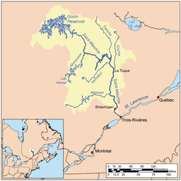 | |
The Saint-Maurice River flows North to South in central Quebec from Gouin Reservoir to empty into the Saint Lawrence River at Trois-Rivières, Quebec.[2] From its source at Gouin Reservoir, located at the same latitude as the Lac Saint-Jean, the river has a total drop of about 405 meters, to finally reach the river Trois-Rivières. The river is 563 km in length and has a drainage basin of 43,300 km² (16,700 mile²).[3] Saint-Maurice river is one of the most important tributaries of St. Lawrence river.
The main tributaries of the Saint-Maurice River are:
- Matawin River which pours at Matawin;
- Vermillon River (La Tuque) which empties about 23 km (by water) upstream (north) of the Beaumont dam La Tuque;
- Manouane River (La Tuque) which empties north of La Tuque;
- La Trenche River (La Tuque) which empties near the Central Trenche;
- Croche River (La Tuque) which empties at north of La Tuque.
During the 18th century, early fur traders travelled along the river. During the second half of the 19th century, logging became an important industry in the surrounding Mauricie region. For much of the 20th century, the river was used to transport logs to mills down river and it was, and still is, a major source of hydroelectric power.
First communication channel in this region, the river was used by local Native Americans long before the arrival of Europeans on the spot. Early explorations by religious conversion in pain and trappers in search of furs for the trade, it was one of the primary routes of rivers in Quebec.
Several municipalities have been established on its banks, thereby taking advantage of its hydroelectric power where the falls were high enough to install a dam. Among other cities, La Tuque, Shawinigan and Trois-Rivières are the best known, are themselves located along the Route 155 which connects the St. Lawrence River to Lake St. John.
Origin of name
The original name of the river was "Métabéroutin", the name given by Algonquin, which means "discharge of the wind" and in turn, the Attikameks of Haute-Mauricie still call "Sipi Tapiskwan", the "river of the threaded needle". The Abenaki the call for their "Madôbaladenitekw" or the "river that ends". Jacques Cartier named it "River Fouez" (Template:API) in honor of the House of Foix in 1535. However, this name was abandoned in the early seventeenth century to the name of "Three Rivers". Its current name was given in the early eighteenth century in reference to the "fief of Saint-Maurice", the common name of lordship on the west bank and granted about 1668 Maurice Poulin in La Fontaine, government prosecutor Three Rivers. He was the owner of some property along the river in the 17th century.[4] The name "St. Maurice" is attested for the first time in a judgment dated 1723 and has definitely supplanted the "Three Rivers" between 1730 and 1740.
The river gave its name to the administrative region of Mauricie.
Communities on the river include:
Tributaries of this river include the:
- Trenche River
- Vermillon River (La Tuque)
- Matawin River
See also
- List of Quebec rivers
- 1663 Charlevoix earthquake
References
- ↑ 1.0 1.1 1.2 Natural Resources Canada > Atlas of Canada > Rivers
- ↑ Toponymy Commission. # Saguenay "Gender (male or female) names of rivers when their generic (river, stream ...) are omitted". Retrieved November 11, 2008. Unknown parameter
|online=ignored (help) - ↑ The Canadian Encyclopedia
- ↑ "Rivière Saint-Maurice". Topos Web. Toponymy Commission. Retrieved September 28, 2008. Unknown parameter
|online=ignored (help)
External links
| Wikimedia Commons has media related to Saint-Maurice River. |
- Tourisme Mauricie Regional tourist office