Saint-Laurent-des-Combes, Charente
From Wikipedia, the free encyclopedia
| Saint-Laurent-des-Combes | |
|---|---|
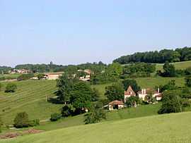 | |
 Saint-Laurent-des-Combes | |
|
Location within Poitou-Charentes region  Saint-Laurent-des-Combes | |
| Coordinates: 45°21′23″N 0°02′14″E / 45.3564°N 0.0372°ECoordinates: 45°21′23″N 0°02′14″E / 45.3564°N 0.0372°E | |
| Country | France |
| Region | Poitou-Charentes |
| Department | Charente |
| Arrondissement | Cognac |
| Canton | Brossac |
| Intercommunality | Sud-Charente |
| Government | |
| • Mayor (2008–2014) | Christophe Damour |
| Area | |
| • Land1 | 7.67 km2 (2.96 sq mi) |
| Population (2008) | |
| • Population2 | 95 |
| • Population2 Density | 12/km2 (32/sq mi) |
| INSEE/Postal code | 16331 / 16480 |
| Elevation |
74–174 m (243–571 ft) (avg. 128 m or 420 ft) |
|
1 French Land Register data, which excludes lakes, ponds, glaciers > 1 km² (0.386 sq mi or 247 acres) and river estuaries. 2 Population without double counting: residents of multiple communes (e.g., students and military personnel) only counted once. | |
Saint-Laurent-des-Combes is a commune in the Charente department in southwestern France.
Population
| Historical population | ||
|---|---|---|
| Year | Pop. | ±% |
| 1793 | 383 | — |
| 1800 | 228 | −40.5% |
| 1806 | 352 | +54.4% |
| 1821 | 359 | +2.0% |
| 1831 | 400 | +11.4% |
| 1841 | 376 | −6.0% |
| 1846 | 345 | −8.2% |
| 1851 | 367 | +6.4% |
| 1856 | 348 | −5.2% |
| 1861 | 322 | −7.5% |
| 1866 | 312 | −3.1% |
| 1872 | 310 | −0.6% |
| 1876 | 329 | +6.1% |
| 1881 | 317 | −3.6% |
| 1886 | 296 | −6.6% |
| 1891 | 273 | −7.8% |
| 1896 | 264 | −3.3% |
| 1901 | 226 | −14.4% |
| 1906 | 217 | −4.0% |
| 1911 | 226 | +4.1% |
| 1921 | 207 | −8.4% |
| 1926 | 190 | −8.2% |
| 1931 | 201 | +5.8% |
| 1936 | 185 | −8.0% |
| 1946 | 193 | +4.3% |
| 1954 | 208 | +7.8% |
| 1962 | 181 | −13.0% |
| 1968 | 167 | −7.7% |
| 1975 | 144 | −13.8% |
| 1982 | 133 | −7.6% |
| 1990 | 89 | −33.1% |
| 1999 | 71 | −20.2% |
| 2008 | 95 | +33.8% |
See also
References
| Wikimedia Commons has media related to Saint-Laurent-des-Combes (Charente). |
This article is issued from Wikipedia. The text is available under the Creative Commons Attribution/Share Alike; additional terms may apply for the media files.