Saint-Étienne-au-Mont
From Wikipedia, the free encyclopedia
| Saint-Étienne-au-Mont | |
|---|---|
 Saint-Étienne-au-Mont | |
|
Location within Nord-Pas-de-Calais region  Saint-Étienne-au-Mont | |
| Coordinates: 50°40′56″N 1°37′37″E / 50.6822°N 1.6269°ECoordinates: 50°40′56″N 1°37′37″E / 50.6822°N 1.6269°E | |
| Country | France |
| Region | Nord-Pas-de-Calais |
| Department | Pas-de-Calais |
| Arrondissement | Boulogne-sur-Mer |
| Canton | Samer |
| Intercommunality | Communauté d'agglomération du Boulonnais |
| Government | |
| • Mayor (2012–2014) | Brigitte Passebosc |
| Area | |
| • Land1 | 14.05 km2 (5.42 sq mi) |
| Population (2006) | |
| • Population2 | 5,112 |
| • Population2 Density | 360/km2 (940/sq mi) |
| INSEE/Postal code | 62746 / 62360 |
| Elevation |
3–113 m (9.8–370.7 ft) (avg. 7 m or 23 ft) |
|
1 French Land Register data, which excludes lakes, ponds, glaciers > 1 km² (0.386 sq mi or 247 acres) and river estuaries. 2 Population without double counting: residents of multiple communes (e.g., students and military personnel) only counted once. | |
Saint-Étienne-au-Mont (English: Saint-Etienne-au-Mont, Dutch: Sint-Steven Berg) is a commune in the Pas-de-Calais department in the Nord-Pas-de-Calais region of France. Besides the main settlement Saint-Étienne-au-Mont, the commune consists of the two smaller settlements Pont-de-Briques and Écault.
Geography
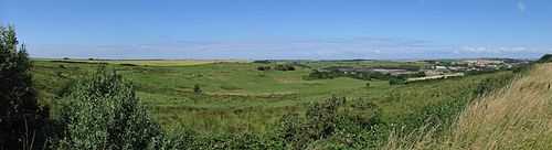
Panorama from the mount Ecault and in the Background, the English Channel with the UK.
Saint-Étienne-au-Mont is a small farming and light industrial town situated some 3 miles (4.8 km) south of Boulogne, at the junction of the D52 and D940 roads. The Liane river forms the north and eastern border of the commune, the English Channel the western.
Population
| 1962 | 1968 | 1975 | 1982 | 1990 | 1999 | 2006 |
|---|---|---|---|---|---|---|
| 3423 | 4389 | 4301 | 4632 | 5037 | 4995 | 5112 |
| Census count starting from 1962: Population without duplicates | ||||||
Places of interest

Saint-Etienne Coast Arms
- The church of St.Etienne, dating from the fifteenth century.
- The château d'Audisque, dating from the eighteenth century.
- The château des Lions, dating from the nineteenth century.
- The St. Etienne-au-Mont Communal Cemetery (Commonwealth War Graves Commission cemetery) created during World War I for men of the Chinese Labour Corps and of the South African Native Labour Corps.
- The sand dunes along the beach.
See also
References
External links
| Wikimedia Commons has media related to Saint-Étienne-au-Mont. |
- Official town website (French)
- Saint-Étienne-au-Mont on the Quid website (French)
- The CWGC cemetery
- The St. Etienne-au-Mont Communal Cemetery on the website "Remembrance Trails of the Great War in Northern France"
- ARENA - Centre d'interprétation de l'environnement (French)
This article is issued from Wikipedia. The text is available under the Creative Commons Attribution/Share Alike; additional terms may apply for the media files.