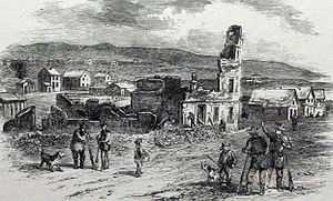
Sacking of Lawrence
| ||||||||||||||||||||||||||||||
|
|
||||||||||||||||||||||||||||||
The Sacking of Lawrence occurred on May 21, 1856, when pro-slavery activists attacked and ransacked the town of Lawrence, Kansas, which had been founded by anti-slavery settlers. The incident helped ratchet up the guerrilla war in Kansas Territory that became known as Bleeding Kansas.
Background
Lawrence was established in 1854 by anti-slavery settlers, many with the help of the New England Emigrant Aid Company, and soon became the center of pro-slavery violence in Kansas Territory. While the village had been besieged in December 1855, it was not directly attacked at that time. The non-fatal shooting of Douglas County Sheriff Samuel Jones on April 23, 1856, while he was attempting to arrest free-state settlers in Lawrence, is believed to have been the immediate cause of the violence.[1] Lawrence residents drove Jones out of town after he was shot and on May 11, Federal Marshal J. B. Donaldson proclaimed that this action had interfered with the execution of warrants against the extralegal Free-State legislature, which had been set up in opposition to the official pro-slavery territorial government.[1] Building on this proclamation and a finding by a grand jury that Lawrence's Free State Hotel was actually built as a fort, Sheriff Jones collected a posse of 800 southerners to enter Lawrence, disarm the citizens, wreck the town's anti-slavery presses, and destroy the Free State Hotel.[2][3]
Sacking

On May 21, 1856, a posse of 800 southerners led by Sheriff Jones gathered closer to the town. A large force was stationed on Mount Oread and cannon planted so as to cover and command the place. The house of Lawrence resident, and the first governor of Kansas, Charles L. Robinson was taken as headquarters for the Marshal and the officers of his army. On every road leading to the town and on the opposite side of the river, detachments of troops were posted to prevent escape from the assault. The forces mustered two flags. The blood-red flag, on which was inscribed "Southern-rights," floated side by side that day with the "stars and stripes."[4]
The two printing offices were sacked, the presses destroyed, and the type thrown in the river. The planned work was finished by destroying the Free State Hotel. The first shot was fired from a cannon on the opposite side of Massachusetts Street by David Rice Atchison, but it failed to hit the building. About fifty shots were afterwards fired with little effect upon the solid walls. Next the posse attempted to blow it up. Several kegs of gunpowder were exploded within, with no appreciable damage to the walls. Its destruction was finally caused by an incendiary, and in the early evening it was a roofless, smoldering ruin. This work was followed by petty robberies and looting throughout the half-deserted town.[4] As the men left, they burned Robinson's private dwelling on Mount Oread.
There was one fatality, a slavery proponent killed by falling masonry.[5]
See also
- Kansas-Nebraska Act
- Lawrence Massacre, a separate attack on Lawrence on August 21, 1863, during the American Civil War.
- List of battles fought in Kansas
References
- ↑ 1.0 1.1 Durwood Ball, Army Regulars on the Western Frontier, 1848-1861 (Norman: University of Oklahoma Press, 2001), 174
- ↑ Durwood Ball, Army Regulars on the Western Frontier, 1848-1861 (Norman: University of Oklahoma Press, 2001), 175
- ↑ Jay Monaghan, Civil War on the Western Border, 1854-1865 (Lincoln: University of Nebraska Press, 1984), 57
- ↑ 4.0 4.1 Monaghan, Civil War on the Western Border, 58
- ↑ Ross Drake, "The Law That Ripped America In Two," Smithsonian Magazine, May 1, 2004.
External links
- Eyewitness account of the Sack of Lawrence, 1856
- Drake, Ross. "The Law That Ripped America In Two." Smithsonian Magazine. May 1, 2004
- Griffin, C. S. "The University of Kansas and the Sack of Lawrence: A Problem of Intellectual Honesty." Kansas Historical Quarterly 34, no. 4 (Winter 1968): 409-426.
- Smiley, Jane. The All-True Travels and Adventures of Lidie Newton: A Novel (1998; ISBN 0-00-225743-2). Historical novel relating to the sack of Lawrence and other events in Kansas Territory's history.
- Territorial Kansas Online: A Virtual Repository for Kansas Territorial History.
Coordinates: 38°57′36″N 95°15′12″W / 38.96000°N 95.25333°W
| |||||||||||||||||||

