This article is about the district.
For its eponymous headquarters, see
Rudraprayag.
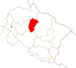
Rudraprayag district, (Hindi: रुद्र प्रयाग जिला) is a district of Uttarakhand state of northern India. The district occupies an area of 2439 km². Rudraprayag town is the administrative headquarters of the district.
The district is bounded by Uttarkashi District on the north, Chamoli District on the east, Pauri Garhwal District on the south, and Tehri Garhwal District on the south.
Location
Rudraprayag District was established on 16th September1997. The district was carved out from the following areas of three adjoining districts.
1. Whole of Augustmuni & Ukhimath block and part of Pokhri & Karnprayag block from Chamoli District.
2. Part of Jakholi and Kirtinagar block from Tehri District.
3. Part of Khirsu block from Pauri District.
Internationally Known Shri Kedarnath Temple is at North, Madmaheshwar at east, Nagrasu at southern east and Shrinagar at extreme south. The Mandakini River is the main river of the district.
As of 2011 it is the least populous district of Uttarakhand (out of 13).[1]
Demographics
According to the 2011 census Rudraprayag district has a population of 236,857,[1] roughly equal to the nation of Vanuatu.[2] This gives it a ranking of 585th in India (out of a total of 640).[1] The district has a population density of 119 inhabitants per square kilometre (310 /sq mi) .[1] Its population growth rate over the decade 2001-2011 was 4.14%.[1] Rudraprayag has a sex ratio of 1120 females for every 1000 males making it the 6th highest in the country as per 2011 census, second being Almora that too in uttarakhand,[1] and a literacy rate of 82.09%.[1]
Prime Shrines/Temples in the vicinity
Cities, towns and villages in Rudraprayag
- Lwara village Distance from rudraprayag is approximately between 45to46 km,near Guptakashi at 7 km.Population between 1000-1500.Temple of MAA CHANDIKA is situated in centre of village.The RAWAN GANGA flows at distance of 1 km from village....from R.B.
- Andarwari Near Guptkashi just 45 km away from Rudraprayag city & 5 km away from Guptkashi city. Amit Semwal
- Rudraprayag
- Sumerpur
- Uthind
- Pola
- Maikoti
- Darmola
- Sann Village distance from Rudraprayag city are= 7.00 km.
- Biron Dewal Village
- Basti Vilage, is a beautiful village,have two temple one of durga devi & another one is Bharkeshwar mahadev temple.near about Bansbada Approx.3 K.M. so far vai walkathon or by vehicle.(Vijaypal Singh Negi)
- Darmwari
- Benji Village
- Syund Village
- Triyuginarayan village
- Guptakashi
- Gaurikund
- Kamera
- Syund
- Dholsari
- Jaggi Kandai village
- Bainji Kandai Dashjula village
- JARMWAR Dashjula village
- Dangi just 15 km away fromRudraprayag city. satish
- ukhimath,masoona,ransi,gaundar,panchkedar(temple)
- gaurikund,village
- paldwari ,VILLAGE
- KYARK,Village
- Tilwara,Village
- kamera,Village
- Maikoti
- Nagrasu
- °Ratura 8 km away from Rudraprayag,Odali Village 1KM (Approx) away from Ratura Market
- Kalna Village: Kalna Village is Situated in center of Rudraprayag and Gaucher (Rudraprayag to Gaucher is 22 km)
- kokhandi, village
- Phalasi (फलासी) Village: Near Chopta just 20 km away from Rudraprayag city. By Ajeet iirBartwal.
- Chond Village: Near Chopta just 20 km away from Rudraprayag city. By Neeraj Vashist
- Bhatwari village
- jakhwadi bangar near khaliyan bangar.by chef sajjan singh dhirwan , Singapore
- Jakholi: Block head Quarter situated near Tilwada >Chirbatiya>Ghansali> Tehri,Scenic and pleasant
- Basukedar: Basukedar (reputedly where Shiva lived before coming to Kedarnath).It's a Shiva temple constructed by Pandava. This is around 35 km from Agustmuni. This is actually an old track to visit Kedarnath. It is said that Lord Shiva stayed a night in while he was travelling to Mount Kailash.
- Kandi village :Kandi village is a famose of LORD SRI KAULAJEET,it is 20KM away from Chandrapuri. By Kuldeep Singh Negi(Sigs).
- Amkoti town: At Tilwada - Ghansali Road, 9 km away from Jakholi.Meet point of KUND and PATIYANGANA fair of NAGELA DEVTA...:Upendra Rana.
See also
Jondla Village near Koteshawar Mahdev & 18 km. From Rudraprayag
Makkumath Village Near Ukhimath, Destance District head Qtr- 35
VILLAGE -KANDADHAR ,POST -KANDAI, PATTY BACHANSYUN,DISTRICT RUDARPRYAG,
References
External links
|
|---|
| | Rudraprayag | |
|---|
| Cities and towns
in other districts |
- Almora
- Bageshwar
- Chamoli
- Champawat
- Dehradun
- Haridwar
- Nainital
- Pauri Garhwal
- Pithoragarh
- Tehri Garhwal
- Udham Singh Nagar
- Uttarkashi
|
|---|
|