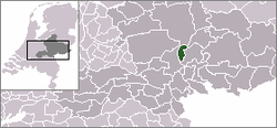
Rozendaal
From Wikipedia, the free encyclopedia
Not to be confused with Roosendaal.
| Rozendaal | |||
|---|---|---|---|
| Municipality | |||
 | |||
| |||
 | |||
| Coordinates: 52°0′N 05°58′E / 52.000°N 5.967°ECoordinates: 52°0′N 05°58′E / 52.000°N 5.967°E | |||
| Country | Netherlands | ||
| Province | Gelderland | ||
| Area(2006) | |||
| • Total | 27.95 km2 (10.79 sq mi) | ||
| • Land | 27.92 km2 (10.78 sq mi) | ||
| • Water | 0.02 km2 (0.008 sq mi) | ||
| Population (1 January, 2007) | |||
| • Total | 1,533 | ||
| • Density | 55/km2 (140/sq mi) | ||
| Source: CBS, Statline. | |||
| Time zone | CET (UTC+1) | ||
| • Summer (DST) | CEST (UTC+2) | ||
Rozendaal (![]() pronunciation (help·info)) is a municipality and a town in the eastern Netherlands, in the province of Gelderland. The town, next to Arnhem and Velp, is known for the Castle of Rozendaal (Kasteel Rosendael) and its bedriegertjes.
pronunciation (help·info)) is a municipality and a town in the eastern Netherlands, in the province of Gelderland. The town, next to Arnhem and Velp, is known for the Castle of Rozendaal (Kasteel Rosendael) and its bedriegertjes.
The municipality is the least densely populated on the mainland of the Netherlands, i.e., in effect, not on one of the West Frisian Islands.
Population centres
- Imbosch
- Rozendaal
- Terlet
External links
 Media related to Rozendaal at Wikimedia Commons
- Official Website (Dutch)
 |
Apeldoorn | Brummen |  | |
| Arnhem | |
Rheden | ||
| ||||
| | ||||
| Rheden |
This article is issued from Wikipedia. The text is available under the Creative Commons Attribution/Share Alike; additional terms may apply for the media files.


