Ropice
| Ropice Ropica | |||
|---|---|---|---|
| Village | |||
 | |||
| |||
 | |||
| Coordinates: 49°42′0″N 18°36′20″E / 49.70000°N 18.60556°E | |||
| Country | Czech Republic | ||
| Region | Moravian-Silesian | ||
| District | Frýdek-Místek | ||
| First mentioned | 1305 | ||
| Government | |||
| • Mayor | Urszula Wania | ||
| Area | |||
| • Total | 10.1 km2 (3.9 sq mi) | ||
| Elevation | 310 m (1,020 ft) | ||
| Population (2012) | |||
| • Total | 1,512 | ||
| • Density | 150/km2 (390/sq mi) | ||
| Postal code | 739 56 | ||
| Website | http://www.ropice.cz/ | ||
![]() Ropice (help·info) (Polish: Ropica , German: Roppitz) is a village in the Czech Republic. It lies in the Frýdek-Místek District of the Moravian-Silesian Region. Ropice has a population of 1,417 (2006), 28.9% of which are Poles.[1] Ropičanka River flows into the Olza River in the village. It lies in the historical region of Cieszyn Silesia.
Ropice (help·info) (Polish: Ropica , German: Roppitz) is a village in the Czech Republic. It lies in the Frýdek-Místek District of the Moravian-Silesian Region. Ropice has a population of 1,417 (2006), 28.9% of which are Poles.[1] Ropičanka River flows into the Olza River in the village. It lies in the historical region of Cieszyn Silesia.
The village was first mentioned in a written document in 1305 as Ropiza.[2] Owners of Ropica in 15th century, the Sobek family, built a fort in the village. It was rebuilt to a baroque château around 1700 and then to a classicist one in 1810. It remains in that style today, although it dilapidated during the communist era and is now completely devastated.
There is a modern golf course in Ropice.
Footnotes
- ↑ "2001 census data". Czech Statistical Office.
- ↑ Hosák et al. 1980, 377.
References
- Cicha, Irena; Kazimierz Jaworski, Bronisław Ondraszek, Barbara Stalmach and Jan Stalmach (2000). Olza od pramene po ujście. Český Těšín: Region Silesia. ISBN 80-238-6081-X.
- Hosák, Ladislav; and Rudolf Šrámek (1980). Místní jména na Moravě a ve Slezsku II, M-Ž. Praha: Academia.
External links
- (Czech) Official website
- (Czech) unOfficial website
-
Devastated château
-
.jpg)
Devastated château in 2012
-

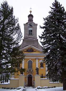
Roman Catholic church
-

Roman Catholic church
-
Lutheran chapel
| Wikimedia Commons has media related to Ropice. |
| ||||||||
| |||||||||||||||||||
Coordinates: 49°42′0″N 18°36′20″E / 49.70000°N 18.60556°E


