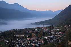
Roncegno Terme
From Wikipedia, the free encyclopedia
| Roncegno Terme | |
|---|---|
| Comune | |
| Comune di Roncegno Terme | |
 | |
 Roncegno Terme | |
| Coordinates: 46°3′3″N 11°24′36″E / 46.05083°N 11.41000°ECoordinates: 46°3′3″N 11°24′36″E / 46.05083°N 11.41000°E | |
| Country | Italy |
| Region | Trentino-Alto Adige/Südtirol |
| Province | Trentino (TN) |
| Frazioni | Marter, Monte di Mezzo, S. Brigida e 44 Masi |
| Area | |
| • Total | 38 km2 (15 sq mi) |
| Elevation | 535 m (1,755 ft) |
| Population (2005) | |
| • Total | 2,604 |
| • Density | 69/km2 (180/sq mi) |
| Demonym | Roncegnesi (Ronzegnari) |
| Time zone | CET (UTC+1) |
| • Summer (DST) | CEST (UTC+2) |
| Postal code | 38050 |
| Dialing code | 0461 |
| Patron saint | Saint Peter and Saint Paul |
| Saint day | 29 June |
| Website | Official website |
Roncegno Terme (German: Rundscheinberg) is a comune (municipality) in Trentino in the northern Italian region Trentino-Alto Adige/Südtirol, located about 20 km east of Trento.
Geography
The municipality of Roncegno contains the frazioni (subdivisions, mainly villages and hamlets) Marter, Monte di Mezzo, S. Brigida and 44 Masi. Roncegno borders the following municipalities: Fierozzo, Torcegno, Ronchi Valsugana, Frassilongo, Borgo Valsugana and Novaledo.
The comune occupies an area of 38.1 km².[1] As of 31 December 2004, it had a population of 2,564.
Demographics

References
External links
- (Italian) comuneroncegno.it
This article is issued from Wikipedia. The text is available under the Creative Commons Attribution/Share Alike; additional terms may apply for the media files.
