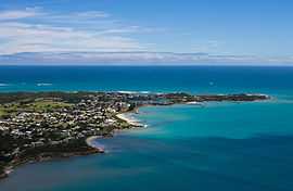
Robe, South Australia
| Robe South Australia | |||||||
|---|---|---|---|---|---|---|---|
 Aerial photograph | |||||||
 Robe | |||||||
| Coordinates | 37°09′0″S 139°45′0″E / 37.15000°S 139.75000°ECoordinates: 37°09′0″S 139°45′0″E / 37.15000°S 139.75000°E | ||||||
| Population | 1,246 (2006)[1] | ||||||
| Postcode(s) | 5276 | ||||||
| Location |
| ||||||
| LGA(s) | District Council of Robe | ||||||
| State electorate(s) | MacKillop | ||||||
| Federal Division(s) | Barker | ||||||
| |||||||
Robe is a town and fishing port on the South East Limestone Coast of South Australia. The town's distinctive combination of historical buildings, ocean, fishing fleets, lakes and dense bush is widely appreciated. Robe lies on the southern shore of Guichen Bay, just off the Princes Highway. At the 2006 census, Robe had a population of 1,246.[1] Robe is the main town in the District Council of Robe local government area. It is in the state electorate of MacKillop and the federal Division of Barker.
History
Guichen Bay was named by the French explorer Nicolas Baudin after Admiral De Guichen in 1802, as he was charting the south coast of Australia. Part of it is protected in the Guichen Bay Conservation Park. Robe is one of the oldest towns in South Australia, founded by the colonial government as a seaport, administrative centre and village only ten years after British settlers formally established the Province of South Australia.
Robe was named after the fourth Governor of South Australia, Major Frederick Robe, who chose the site as a port in 1845. The town was proclaimed as a port in 1847. It became South Australia's second-busiest (after Port Adelaide) international port in the 1850s. Robe's trade was drawn from a large hinterland that extended into western Victoria, and many roadside inns were built to cater for the bullock teamsters bringing down the wool, including th 'Bush Inn' still standing on the outskirts of Robe. Exports included horses and sheep skins and wool. The Customs House is listed by the National Trust of Australia. A stone obelisk was built on Cape Dombey in 1852 to assist ships to navigate safely into the bay. Even so, there have been a number of shipwrecks along the coast in the area. An automatic lighthouse was built on higher ground in 1973.
During the Victorian gold rushes around 1857, over 16,000 Chinese people landed at Robe to travel overland to the goldfields, as Victoria introduced a landing tax of £10 per person (more than the cost of their voyage) to reduce the number of Chinese immigrants. The immigrants then walked the 200 miles (320 km) to Ballarat and Bendigo.
Robe's importance decreased with the advent of railways which didn't come to the town. It became a local service centre for the surrounding rural areas. It is still home to a fleet of fishing boats. Especially important are the local lobsters.
Environment
Between Robe in the north and Beachport in the south stretches a series of coastal lakes which have been recognised as the Lake Hawdon System Important Bird Area because of their global importance for waterbirds.[2]
Climate
| Climate data for Robe | |||||||||||||
|---|---|---|---|---|---|---|---|---|---|---|---|---|---|
| Month | Jan | Feb | Mar | Apr | May | Jun | Jul | Aug | Sep | Oct | Nov | Dec | Year |
| Average high °C (°F) | 22.5 (72.5) |
22.6 (72.7) |
21.1 (70) |
18.8 (65.8) |
16.4 (61.5) |
14.3 (57.7) |
13.6 (56.5) |
14.3 (57.7) |
15.7 (60.3) |
17.6 (63.7) |
19.5 (67.1) |
21.2 (70.2) |
18.1 (64.6) |
| Average low °C (°F) | 13.6 (56.5) |
13.7 (56.7) |
12.7 (54.9) |
11.5 (52.7) |
10.2 (50.4) |
8.7 (47.7) |
8.1 (46.6) |
8.5 (47.3) |
9.2 (48.6) |
10.2 (50.4) |
11.4 (52.5) |
12.7 (54.9) |
10.9 (51.6) |
| Precipitation mm (inches) | 20.2 (0.795) |
18.7 (0.736) |
26.7 (1.051) |
46.2 (1.819) |
73.0 (2.874) |
95.4 (3.756) |
104.4 (4.11) |
85.6 (3.37) |
59.3 (2.335) |
44.3 (1.744) |
30.3 (1.193) |
28.1 (1.106) |
631.5 (24.862) |
| Source: [3] | |||||||||||||
See also
| Wikimedia Commons has media related to Robe, South Australia. |
References
- ↑ 1.0 1.1 Australian Bureau of Statistics (25 October 2007). "Robe (Urban Centre/Locality)". 2006 Census QuickStats. Retrieved 2010-01-31.
- ↑ "IBA: Lake Hawdon System". Birdata. Birds Australia. Retrieved 2011-07-29.
- ↑ "Climate Statistics For Robe". Australian Bureau of Meteorology.
- Susan Marsden, A glimpse of golden days, District Council of Robe, 1985.