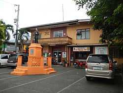
Rizal, Laguna
| Rizal | ||
|---|---|---|
| Municipality | ||
 | ||
| ||
 | ||
.svg.png) Rizal | ||
| Coordinates: 14°06′33″N 121°23′40″E / 14.10917°N 121.39444°ECoordinates: 14°06′33″N 121°23′40″E / 14.10917°N 121.39444°E | ||
| Country | Philippines | |
| Region | CALABARZON (Region IV-A) | |
| Province | Laguna | |
| District | 3rd district of Laguna | |
| Founded | January 7, 1919 | |
| Barangays | 11 | |
| Government[1] | ||
| • Mayor | Antonino A. Aurelio | |
| Area[2] | ||
| • Total | 27.90 km2 (10.77 sq mi) | |
| Population (2010)[3] | ||
| • Total | 15,518 | |
| • Density | 560/km2 (1,400/sq mi) | |
| Time zone | PST (UTC+8) | |
| ZIP code | 4003 | |
| Dialing code | 49 | |
| Income class | 5th | |
Rizal is a fifth class municipality in the province of Laguna, Philippines. It is a landlocked municipality of located 25 kilometres (16 mi) from the provincial capital Santa Cruz and is bounded on the north by municipality of Calauan, on the east by Nagcarlan, on the west by San Pablo City, and on the south by Dolores, Quezon. According to the 2010 census, it has a population of 15,518 people.[3] This municipality was named after José Rizal, the country's national hero.
From San Pablo is a downhill road leading to Rizal. Rizal is one of the youngest towns in Laguna although it has long been sitting there amidst coconut trees, hiding in the shadows of Mount San Cristobal, Mount Banahaw, and Mount Basilin.
Barangays
Rizal is politically subdivided into 11 barangays.[2]
- Antipolo
- Entablado
- Laguan
- Paule 1
- Paule 2
- East Poblacion
- West Poblacion
- Pook
- Tala
- Talaga
- Tuy
History
Kaingeros, must have settled only on this plot of land during the early 17th century. Maybe only during the time Nagcarlan was building its town hall in the mid 1800 did this small village then called “Pauli” became a barrio of Nagcarlan.
Residents say that the name of this sleepy village got its name from the character of a brook at the edge of the settlement, whose stream flows back and forth. “Pauli,” must have come from the Tagalog word “Pauli-uli,” which means back and forth.
Ever since, local villagers earn their living by farming. Natural springs in almost every corner of the village make settlers enjoy bountiful harvests of coconuts, root crops, vegetables, and rice. Locales also thrive by fishing from nearby rivers and Lake Calibato, one of San Pablo’s seven lakes.
It was only during the American regime did Pauli become a town, independent from Nagcarlan. The American Federal Government named Pedro Urrea the municipal president. Nevertheless, Pauli’s township lasted only for a brief two years. Its inability to support its administrative expenses caused Pauli to affiliate once more with its former mother town.
However, between 1912 and 1915, residents led by Fortunato Arban, Agustin Vista, and Felix Isles, former municipal councilors campaigned to regain their municipal status. The petition included the inclusion of barrios Antipolo, Entablado, Laguan, Pook, Mayton, Pauli, Talaga and Tuy. On December 18, 1918, Governor Charles M. Yeater issued Executive Order 56 creating the Municipality of Rizal, naming the town after the foremost national hero Dr. Jose P. Rizal.
Officials inaugurated the new town a year after on January 7, 1919 naming Fortunato Arban town mayor.Before the citizens of Pauli won back their township, Inocente Sumague donated a piece of land for the construction of a church in 1916. Construction workers quarried Mayton Creek for stones and gravel. The quarry claimed many lives before the construction ended, in time for the midnight mass of Christmas of 1917.
Demographics
| Population census of Rizal | ||
|---|---|---|
| Year | Pop. | ±% p.a. |
| 1990 | 9,501 | — |
| 1995 | 11,537 | +3.96% |
| 2000 | 13,006 | +2.43% |
| 2007 | 15,459 | +2.50% |
| 2010 | 15,518 | +0.13% |
| Source: National Statistics Office[3] | ||
References
- ↑ "Official City/Municipal 2013 Election Results". Intramuros, Manila, Philippines: Commission on Elections (COMELEC). 11 September 2013. Retrieved 20 November 2013.
- ↑ 2.0 2.1 "Province: LAGUNA". PSGC Interactive. Makati City, Philippines: National Statistical Coordination Board. Retrieved 20 November 2013.
- ↑ 3.0 3.1 3.2 "Total Population by Province, City, Municipality and Barangay: as of May 1, 2010". 2010 Census of Population and Housing. National Statistics Office. Retrieved 20 November 2013.
External links
| Wikimedia Commons has media related to Rizal, Laguna. |
- Philippine Standard Geographic Code
- Philippine Census Information
- Local Governance Performance Management System
 |
Nagcarlan |  | ||
| San Pablo | |
Nagcarlan | ||
| ||||
| | ||||
| San Pablo | Dolores, Quezon |
| ||||||||

