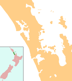
Riverhead, New Zealand
| Riverhead | |
|---|---|
 Riverhead | |
| Coordinates: 36°45′31″S 174°35′32″E / 36.75861°S 174.59222°E | |
| Country | New Zealand |
| Region | Auckland Region |
| District | Rodney District |
Riverhead is a small, historically predominantly working-class town located at the head of the Waitemata Harbour in the north-west of Auckland, New Zealand. The region around Riverhead and the neighbouring towns of Kumeu and Huapai is known for its vineyards. This town has had its 15 minutes in the spotlight appearing in movies Bridge to Teribithia[1] and Crooked Earth[citation needed] and the odd television show such as Outrageous Fortune.[citation needed]
Riverhead was briefly a railway terminus in the 19th century, located at the eastern end of the isolated Kumeu-Riverhead Section. The line operated from 1875 and 1881 as a link from Auckland to regions north, with Riverhead acting as the transition point from ferry to railway. When the North Auckland Line connected Kumeu with Auckland via rail in 1881, the coastal shipping became unnecessary, and with no reason to continue operating, the railway to Riverhead was closed.
The region features a pine plantation forest that is popular with walkers, horse riders (http://bridleways.googlepages.com/riverhead), mountain bikers (http://www.wcrc.co.nz) and motor cyclists (http://www.waitematamcc.co.nz). Riverhead Forest is operated by Matariki Forests, under Crown Licence. The forest was originally planted on poor kauri gum fields.
Riverhead is featuring a pub (The Riverhead), a restaurant (Hallertau) and a cosy little but stylish cafe (Kauri Gum Country Store & Cafe) and a dairy.
Education
Riverhead School is a coeducational full primary (years 1-8) school with a decile rating of 8 and a roll of 268.[2] The school was built in 1872, and substantially rebuilt in 1960.[3] In 2010 six new classrooms, a resource room and a library were added.
Scouts
Riverhead has a vibrant scout group.
Notes
- ↑ Filming locations for Bridge to Terabithia
- ↑ "Te Kete Ipurangi - Riverhead School". Ministry of Education. Retrieved 2010-12-08.
- ↑ "HISTORY - Riverhead School". Riverhead School. Retrieved 2010-12-08.
External links
Coordinates: 36°45′S 174°36′E / 36.750°S 174.600°E