River Gaunless
From Wikipedia, the free encyclopedia
| River Gaunless | |
| River | |
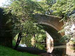
 The River Gaunless in the grounds of Auckland Castle. | |
| Country | England |
|---|---|
| District | County Durham |
| Source | |
| - location | Copley |
| - elevation | 230 m (755 ft) |
| - coordinates | 54°37′12″N 1°52′12″W / 54.62000°N 1.87000°W |
| Mouth | |
| - location | River Wear, Bishop Auckland |
| - elevation | 70 m (230 ft) |
| - coordinates | 54°40′15.60″N 1°40′10.20″W / 54.6710000°N 1.6695000°W |
The River Gaunless is a river of County Durham in England.Its name was given by the Vikings, who found no major uses for it and thus Gaunless, meaning 'useless', became fixed.[1]
- ↑ A Potted History of West Auckland - Martin Connolly
Formed just south of the village of Copley, by the confluence of Arn Gill (to the south, coming west from south of Langleydale Common) and Hindon Beck (to the north and coming east from Langleydale Common), the Gaunless wends its way east, passing the settlements of Butterknowle, Cockfield and Evenwood and through West Auckland before skirting the south and east of Bishop Auckland on its way to meet the River Wear.
The Gaunless Viaduct, built in 1825, was the tallest viaduct on the South Durham & Lancashire Union Railway.
Settlements
- Copley
- Butterknowle
- Evenwood
- West Auckland
- Bishop Auckland
Tributaries
- Arn Gill
- Hindon Beck
- Cowclose Beck
- Foul Sike
- Cowclose Beck
- Grewburn Beck
- Howle Beck
- Gordon Beck
- Norton Fine Beck
- Oakley Cross Beck
- Hummer Beck
- Dene Beck
- Coundon Burn
Bridges
References
This article is issued from Wikipedia. The text is available under the Creative Commons Attribution/Share Alike; additional terms may apply for the media files.