Rio Saliceto
From Wikipedia, the free encyclopedia
| Rio Saliceto | |
|---|---|
| Comune | |
| Comune di Rio Saliceto | |
 Rio Saliceto | |
| Coordinates: 44°49′N 10°48′E / 44.817°N 10.800°ECoordinates: 44°49′N 10°48′E / 44.817°N 10.800°E | |
| Country | Italy |
| Region | Emilia-Romagna |
| Province | Province of Reggio Emilia (RE) |
| Frazioni | Commenda, Osteriola, Cà de Frati, San Lodovico |
| Area | |
| • Total | 22.5 km2 (8.7 sq mi) |
| Population (Dec. 2004) | |
| • Total | 5,632 |
| • Density | 250/km2 (650/sq mi) |
| Demonym | Riesi |
| Time zone | CET (UTC+1) |
| • Summer (DST) | CEST (UTC+2) |
| Postal code | 42010 |
| Dialing code | 0522 |
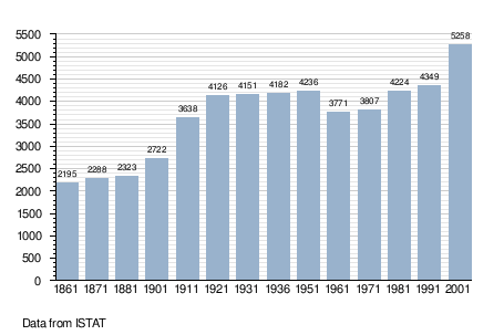
Rio Saliceto is a comune (municipality) in the Province of Reggio Emilia in the Italian region Emilia-Romagna, located about 60 km northwest of Bologna and about 20 km northeast of Reggio Emilia. As of 31 December 2004, it had a population of 5,632 and an area of 22.5 km².[1]
The municipality of Rio Saliceto contains the frazioni (subdivisions, mainly villages and hamlets) Commenda, Osteriola, Cà de Frati, and San Lodovico.
Rio Saliceto borders the following municipalities: Campagnola Emilia, Carpi, Correggio, Fabbrico.
Demographic evolution

Town hall of Rio Saliceto
References
This article is issued from Wikipedia. The text is available under the Creative Commons Attribution/Share Alike; additional terms may apply for the media files.