Rima Rima
From Wikipedia, the free encyclopedia
| Rima Rima | |
|---|---|
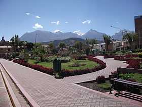
 Wallunarahu and Ranrapallqa (both snow-covered), Rima Rima and Churup (on the right) as seen from Huaraz | |
| Elevation | 5,254 m (17,238 ft)[1] |
| Location | |
 Rima Rima | |
| Location | Peru, Ancash Region |
| Range | Andes, Cordillera Blanca |
| Coordinates | 9°28′S 77°27′W / 9.467°S 77.450°WCoordinates: 9°28′S 77°27′W / 9.467°S 77.450°W[2] |
Rima Rima (Quechua rima speaking, rima rima a flower, Ranunculus weberbaueri syn. Krapfia weberbaueri) is a mountain in the Cordillera Blanca in the Andes of Peru, about 5,254 metres (17,238 ft) high. It is situated in the Ancash Region, Huaraz Province, Independencia District, northeast of the town Huaraz (Waras). Rima Rima lies southeast of the Wallunarahu, on the southwest ridge of Ranrapallqa.
-

Ranrapallqa (in the distance), Rima Rima, Churup (middle, left), Qullapaqu and Wamashrahu as seen from Huaraz
See also
References
- ↑ andix.com Map of a part of the Cordillera Blanca
- ↑ www.peakbagger.com
This article is issued from Wikipedia. The text is available under the Creative Commons Attribution/Share Alike; additional terms may apply for the media files.