Rijssen-Holten
From Wikipedia, the free encyclopedia
| Rijssen-Holten | ||
|---|---|---|
| Municipality | ||
 | ||
| ||
 | ||
| Coordinates: 52°18′N 06°31′E / 52.300°N 6.517°ECoordinates: 52°18′N 06°31′E / 52.300°N 6.517°E | ||
| Country | Netherlands | |
| Province | Overijssel | |
| Area(2006) | ||
| • Total | 94.40 km2 (36.45 sq mi) | |
| • Land | 94.18 km2 (36.36 sq mi) | |
| • Water | 0.22 km2 (0.08 sq mi) | |
| Population (1 January, 2007) | ||
| • Total | 36,577 | |
| • Density | 388/km2 (1,000/sq mi) | |
| Source: CBS, Statline. | ||
| Time zone | CET (UTC+1) | |
| • Summer (DST) | CEST (UTC+2) | |
Rijssen-Holten (![]() pronunciation (help·info)) is a municipality (Dutch: gemeente) in the eastern Netherlands, in the province of Overijssel.
pronunciation (help·info)) is a municipality (Dutch: gemeente) in the eastern Netherlands, in the province of Overijssel.
The municipality was formed in 2001 by the joining of the municipalities of Holten and Rijssen. The area of Holten belongs to the region of Salland and the area of Rijssen to the region of Twente.
Population centres
- Beuseberg,
- De Borkeld,
- Dijkerhoek (2 km west of Holten),
- Espelo,
- Holten,
- Holterberg,
- Holterbroek,
- Lichtenberg,
- Look,
- Neerdorp (currently a part of the village Holten)
- Rijssen
Only Holten and Rijssen have over 500 inhabitants.
Topography

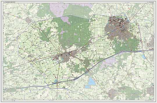
Dutch Topographic map of the municipality of Rijssen-Holten, 2013.
Accessibility
Both Holten and Rijssen are easily accessible by car; the A1 motorway (Amsterdam - Berlin) is only a few kilometres away. The distance between Amsterdam and Holten is about 110 km (68 mi). Rijssen lies 7 km (4.3 mi) more to the east.
External links
| Wikimedia Commons has media related to Rijssen-Holten. |
- Official website (Dutch)
- website of the Holten Tourist Office ( Dutch, German)
- website of the Rijssen Tourist Office ( Dutch, German)
 |
Raalte | Hellendoorn |  | |
| Deventer | |
Wierden | ||
| ||||
| | ||||
| Lochem (GE) | Hof van Twente |
| |||||||||||
This article is issued from Wikipedia. The text is available under the Creative Commons Attribution/Share Alike; additional terms may apply for the media files.

