Ribeirão Pires
From Wikipedia, the free encyclopedia
Coordinates: 23°42′55″S 46°25′10″W / 23.71528°S 46.41944°W
| Ribeirão Pires | |||
|---|---|---|---|
 | |||
| |||
 | |||
| Coordinates: 23°42′55″S 46°25′10″W / 23.71528°S 46.41944°W | |||
| Country |
| ||
| Region | Southeast | ||
| State |
| ||
| Government | |||
| • Mayor | Saulo Benevides (PMDB) | ||
| Area | |||
| • Total | 99.175 km2 (38.292 sq mi) | ||
| Elevation | 800 m (2,600 ft) | ||
| Population (2010)[1] | |||
| • Total | 113 043 | ||
| Time zone | UTC-3 (UTC-3) | ||
| • Summer (DST) | UTC-2 (UTC-2) | ||
| HDI (2000) | 0.807 – high | ||
| Website | Ribeirão Pires | ||

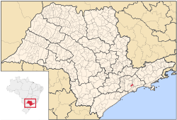
Ribeirão Pires is a city in the state of São Paulo Metropolitan Region of São Paulo (state), including a group of municipalities known as the "Greater ABC Region". The estimated population in 2009 was 112 011 inhabitants and the area is 99 square kilometers, resulting in a density of 1116.07 inhabitants / km ².The elevation is 763 m. Its neighboring cities are Ferraz de Vasconcelos north, northeast and east Suzano, Rio Grande da Serra to the southeast and south, southwest Santo Andre and Mauá northwest. The city is served by trains from line 10 of CPTM. It became a municipality in 1953, when he was emancipated from Santo André.
Famous people from Ribeirão Pires
References
- ↑ "Estimativas - Contagem da População 2007". IBGE. Retrieved 2008-07-11.
| ||||||||||||||||||||||||||||||||||||||||||||||||||||||||||||
This article is issued from Wikipedia. The text is available under the Creative Commons Attribution/Share Alike; additional terms may apply for the media files.