Ribadeo
| Ribadeo | |||
|---|---|---|---|
| Municipality | |||
 | |||
| |||
 Ribadeo | |||
 Ribadeo | |||
| Coordinates: 43°32′1″N 7°2′25″W / 43.53361°N 7.04028°W | |||
| Country |
| ||
| Autonomous Community |
| ||
| Province | Lugo | ||
| Comarca | A Mariña Oriental | ||
| Government | |||
| • Mayor | Fernando Suárez Barcia (BNG) | ||
| Area | |||
| • Total | 106 km2 (41 sq mi) | ||
| Elevation(AMSL) | 571 m (1,873 ft) | ||
| Population (2012) | |||
| • Total | 10,061 | ||
| • Density | 95/km2 (250/sq mi) | ||
| Time zone | CET (UTC+1) | ||
| • Summer (DST) | CEST (GMT +2) (UTC+2) | ||
| Postal code | 27700 | ||
| Area code(s) | +34 (Spain) + 982 (Lugo) | ||
| Website | www.ribadeo.org | ||


Ribadeo is a municipality in the Spanish province of Lugo in Galicia. It has a population of 10,023 (INE, 2011) and an area of 106.2 km2. It is the capital of the A Mariña Oriental comarca.
Geography
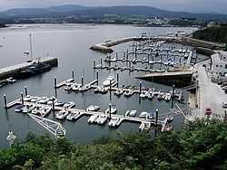
The municipality of Ribadeo has approximately the shape of a 10x10 kilometer square. It is bordered to the north by the Cantabrian Sea, to the east by the Ribadeo estuary (the other side of which is Castropol in Asturias), to the west by the municipality of Barreiros and to the south by Trabada. Other core features reside in the urban center of Rinlo. The capital of the municipality is the villa of Ribadeo. The highest point of the municipality is located in the parish of Cubelas, being the Mondigo mountain.
History
The town was formed from a primitive nucleus in the docks of Porcillán and Cabanela on the banks of the river and would continue to grow upward. It had a wall of financial character more than defensive purposes and some remains are still preserved. Along with Viveiro and Mondoñedo, it was one of three medieval urban phenomenas of the former province of Mondoñedo. receiving either of the hands of Fernando III Town Charter foundational attributed, among other privileges, to hold a weekly market, which is still performed. It had already received the foundational Town Charter from Fernando III along with other privileges which included holding a weekly market, which is still carried out. It went from village to property of royal French gentleman Pierre de Villeines by virtue Enrique de Trastámara generous for payment of his services. Hence by different sequences the county of Ribadeo permanently fell into the House of Alba. Its peak as villa coincided with that of its port, being head of the Cantabrian trade with Baltic countries, through the port of Riga in particular, where liquor was imported exclusively. For this reason it ended up being known as Kúmel of Ribadeo until its decline due to competition from other ports such as Gijón during the mid-nineteenth century.
The coat of arms of the villa is of medieval origin. It is formed on sea waves on which a golden key is found at an inclined angle with a silver star above. The key symbolizes the condition of entry into Galicia and the star its northern location. Until the late seventeenth century the coat of arms lacked the star and the key was in the upright position. This can be seen in the chapel of the Virxe do Camiño, in stone in 1699, at which time it was already ancient.
Demography
The urban population within the parish surpasses more than 6,500 inhabitants. However, the urban agglomeration includes villages and neighborhoods that stretch to the surrounding parishes so that the population reaches 8,000.
External links
| Wikimedia Commons has media related to Ribadeo. |
| |||||
Coordinates: 43°32′N 7°02′W / 43.533°N 7.033°W