Ribadavia
| Concello de Ribadavia | |
|---|---|
 | |
| Parroquias | 7 |
| Government | |
| • Alcalde (Mayor) | Marcos Blanco Jorge |
| Area | |
| • Total | 25.1 km2 (9.7 sq mi) |
| Time zone | CET (UTC+1) |
| • Summer (DST) | CET (UTC+2) |
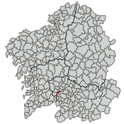
The town of Ribadavia (town pop. 3,365, municipality 5,540, area of municipality 20.2 km²) is located in the southwest of the province of Ourense, Autonomous Community of Galicia, Spain. The urban area lies on the right bank of the Miño (see Portuguese Minho) and the last course of the Avia. It is considered to be the capital of the comarca of the Ribeiro. Near highway N-120 (Ourense to Vigo) and the motorway called Autovia das Rias Baixas (A52), it is 25 km from the provincial capital and 80 km from Vigo.
The town was declared a Historical Artistic Site in 1947. Near the Campo da Feira, one can find the ruins of the castle of the Sarmientos, the Counts of Ribadavia, dating from the fifteenth century. It still preserves the interior, towers and the walls. Parts of the walls that surrounded the town are also still standing. Inside the old quarter (casco vello/Barrio Xudeu), one can visit the main square (Praza Maior) with interesting buildings like the sixteenth-century town hall. There are also buildings remaining from what was once a large Jewish quarter, including a synagogue.
All the economic life of the comarca of the Ribeiro has centered on, since the twelfth century, the vines first brought by the monks of Cluny who accompanied the first count of Galicia, Raymond of Burgundy. Today, the wine is commercialised as Denominación de Orixe Ribeiro. (Demarcated Origen Ribeiro)
Bibliography
- (Spanish) Leopoldo Meruéndano Arias, Los Judíos de Ribadavia y orígen de las cuatro parroquias.
- (Spanish) Samuel Eiján, Historia de Ribadavia y sus alrededores.
External links
- Ribadavia's City Hall Official Page
- Ribadavia's Tourism Page
- Recreating Sephardic Culture in a Galician Town
- Map of Ribadavia by MapQuest
| Wikimedia Commons has media related to Ribadavia. |
Coordinates: 42°17′N 8°08′W / 42.283°N 8.133°W