Reykjanesbær
| Reykjanesbær | ||
|---|---|---|
| Municipality | ||
 | ||
| ||
 | ||
| Coordinates: 64°00′N 22°33′W / 64.000°N 22.550°W | ||
| Country | Iceland | |
| Constituency[1] | Suðurkjördæmi | |
| Region[2] | Suðurnes[3] | |
| County | Gullbringusýsla | |
| Area | ||
| • Total | 145 km2 (56 sq mi) | |
| Population (2013) | ||
| • Total | 14,231 | |
| • Density | 98/km2 (250/sq mi) | |
| Postal codes | 230-232-233-235-260 | |
| Website | Official website | |
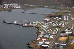
Reykjanesbær is a municipality on the Reykjanes peninsula in Iceland. It is made up of the towns Keflavík, Njarðvík, the village of Hafnir and, since 2006, Ásbrú. The municipality was created in 1995 when the inhabitants of the three towns voted to merge them into one. Reykjanesbær is the fifth largest municipality in Iceland and has a population of 14,231 (1 January 2013).
Overview

Of the three towns which make up the municipality, Keflavík is the largest, while Hafnir is the smallest and some 10 kilometers distant. Keflavík and Njarðvík were originally distinct towns but gradually grew together over the course of the latter half of the 20th century, until the only thing separating them was a single street. The northern side of the street belonged to Keflavík and the southern side to Njarðvík. Since May 2009 the township of Njarðvík has been the location of the Viking World museum. In 2006, when the United States Navy closed Naval Air Station Keflavik, the site was taken over by the development agency Kadeco, and renamed Ásbrú. A university, Keilir, was founded and now Ásbrú houses the campuses of various educational institutions and also businesses, both newly founded and relocated to the site of the air base.
Twin towns — Sister cities
Reykjanesbær has the following sister cities:
- Brighton, England[citation needed]
- Hjørring, Denmark[citation needed]
- Kerava, Finland[citation needed]
- Kristiansand, Norway[4]
- Miðvágur, Faroe Islands[citation needed]
- Orlando, United States[5]
- Trollhättan, Sweden[citation needed]
Sports
Reykjanesbær is famous as the Sport Town of Iceland.[citation needed] It has one major sport club, Njarðvík; other clubs are Keflavík, Golfklúbbur Suðurnesja, Hestamannafélagið Máni, ÍRB and HKR.
Points of interest
References
- ↑ Political division
- ↑ Mainly statistical division
- ↑ Formerly named Reykjanes
- ↑ Kristiansand kommune
- ↑ Sister Cities International
External links
![]() Media related to Reykjanesbær at Wikimedia Commons
Media related to Reykjanesbær at Wikimedia Commons
- Picture gallery at www.islandsmyndir.is
Coordinates: 64°00′04″N 22°33′07″W / 64.00111°N 22.55194°W
