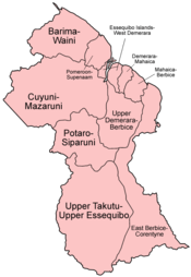
Regions of Guyana
From Wikipedia, the free encyclopedia
.png)

Regions of Guyana by number and name
Guyana is divided into 10 regions:[1][2]
| No. | Region | Area (km²) | Pop. (2002) | Pop. per km² | Capital |
|---|---|---|---|---|---|
| 1 | Barima-Waini | 20,339 | 24,275 | 1.2 | Mabaruma |
| 2 | Pomeroon-Supenaam | 6,195 | 49,253 | 8.0 | Anna Regina |
| 3 | Essequibo Islands-West Demerara | 2,232 | 103,061 | 46.2 | Vreed en Hoop |
| 4 | Demerara-Mahaica | 1,843 | 310,320 | 168.4 | Paradise |
| 5 | Mahaica-Berbice | 3,755 | 52,428 | 14.0 | Fort Wellington |
| 6 | East Berbice-Corentyne | 36,234 | 123,695 | 3.4 | New Amsterdam |
| 7 | Cuyuni-Mazaruni | 47,213 | 17,597 | 0.3 | Bartica |
| 8 | Potaro-Siparuni | 20,051 | 10,095 | 0.5 | Mahdia |
| 9 | Upper Takutu-Upper Essequibo | 57,750 | 19,387 | 1.3 | Lethem |
| 10 | Upper Demerara-Berbice | 19,387 | 41,112 | 2.1 | Linden |
| Guyana | 214,999 | 751,223 | 3.5 | Georgetown |
Each region is administered by a Regional Democratic Council (RDC) which is headed by a Chairman. The regions are divided into neighbourhood councils.[3] known as Neighbourhood Democratic Councils (NDCs).
See also
- ISO 3166-2:GY
- List of Caribbean First-level Subdivisions by Total Area
References
- ↑ Bureau of Statistics - Guyana, CHAPTER III: POPULATION REDISTRIBUTION AND INTERNAL MIGRATION, Table 3.4: Population Density, Guyana: 1980 - 2002
- ↑ Guyana - Government Information Agency, National Profile
- ↑ Government of Guyana, Statistics
External links
- Regions of Guyana at statoids.com
| |||||||||||
This article is issued from Wikipedia. The text is available under the Creative Commons Attribution/Share Alike; additional terms may apply for the media files.