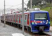
Recife Metro
| Recife Metro | |||
|---|---|---|---|
 | |||
| Background | |||
| Locale | Recife | ||
| Transit type | Rapid transit | ||
| Number of lines | 4 (Lines Centre - 1, Centre - 2, South and Diesel Train) | ||
| Number of stations | 30 | ||
| Daily ridership | 285,000[1] (2012) | ||
| Operation | |||
| Began operation | 1985 | ||
| Operator(s) | Superintendência de Trens Urbanos de Recife | ||
| Technical | |||
| System length | 44.2 km (27.5 mi) | ||
| |||
The Recife Metro (Portuguese: Metrô do Recife, commonly called Metrô) is operated by CBTU/Metrorec, is currently 28 stations and 44.2 km (27.5 mi) long. Recife Metro is the second largest in Brazil, after São Paulo.[2]
System Characteristics
Recife Metro is currently formed by the Central Line (further divided into two lines) and the South line.
The stations were designed with a caution to include various forms of identification. Besides the service of audio messages announcing the name of the stop, there is a different colour used on the walls of every station and their signs are equipped with graphical symbols next to the name which always accompany the maps spread in the buildings.
Trains of the Center Line leaving the station Recife have two distinct destinations: the cities of Camaragibe and of Jaboatão dos Guararapes. This is due to the fact that lines Center-1 (Camaragibe) and Center-2 (Jaboatão) share the part of the railway between Recife and Coqueiral stations, reusing the route of an old railway track where the metro system was built.
In Lines of Metrorec the average distance between stations is of 1.2 kilometers, hence the typical speed of the train is 40 km/h, while the maximum speed is 80 km/h [citation needed]. The gauge is 1600 mm and energy supply for trains is done through aerial catenary.
The system had a total of 25.2 km of routes and, and after completion of the expansion of its network that occurred from February 2005 to March 2009 - it grew to the current 39.5 km. there is also 31.5 km of line for Diesel locomotives, totaling 71 km.[citation needed]
This system also has several bus lines linked from the terminals of bus/metro integration designated S.E.I (Sistema Estrutural Integrado - Integrated Structural System ), through which a passenger can continue their travel on the same ticket.[3]
System
| Line | Terminals | Start date | length (km) | Stations | Duration (min) | Schedule |
|---|---|---|---|---|---|---|
| Center - 1 | Recife ↔ Camaragibe | 11 of March, 1985 | --- | 15*(1) | 28 | Daily, 5 AM to 11 PM |
| Center - 2 | Recife ↔ Jaboatão | 29 of August, 1987 | --- | 14 | 24 | Daily, 5 AM to 11 PM |
| South | Recife ↔ Cajueiro Seco | 28 of February, 2005 | 14,3 | 13 | 25[4] | Daily, 5 AM to 11 PM |
| Recife Metro | Total (C1+C2+S) | 11 of March, 1985 | 39.5 | 29*(1)** | --- | --- |
| Diesel Train*** | Cabo ↔ Curado in Recife | Since 1988 | 31,5 | 9 | 54 | Monday to Saturday, 5 AM to 8 PM |
(*) Under construction Stations, (**) The system has overlapping stations, (***) The diesel train isn't included in the metro service, even under the same administration company
Stations
| Nº | Center - C1 | Center - C2 | South Line - S | Diesel Train - DT |
|---|---|---|---|---|
| 1 | Recife SEI | Recife SEI | Recife SEI | Curado C1 |
| 2 | Joana Bezerra* SEI | Joana Bezerra* SEI | Joana Bezerra* SEI | Jorge Lins |
| 3 | Afogados SEI | Afogados SEI | Largo da Paz SEI | Marcos Freire |
| 4 | Ipiranga | Ipiranga | Imbiribeira | Cajueiro Seco SEI, S |
| 5 | Mangueira | Mangueira | Antonio Falcão | Ângelo de Souza |
| 6 | Santa Luzia SEI | Santa Luzia SEI | Shopping Center Recife | Pontezinha |
| 7 | Edgar Werneck | Edgar Werneck | Tancredo Neves SEI | Ponte dos Carvalhos |
| 8 | Barro SEI | Barro SEI | Aeroporto - Airport SEI | Santo Inácio |
| 9 | Tejipió | Tejipió | Porta Larga | Cabo SEI |
| 10 | Coqueiral** | Coqueiral** | Monte dos Guararapes | |
| 11 | Alto do Céu | Cavaleiro SEI | Prazeres SEI | |
| 12 | Curado DT | Floriano | Cajueiro Seco SEI, DT | |
| 13 | Rodoviária-Coach station | Engenho Velho | ||
| - | Cosme e Damião*** | |||
| 14 | Camaragibe SEI | Jaboatão |
OBS.: SEI means integration with local buses; (*)C1, C2 and S runs in the some line until J. Bezerra; (**) C1 e C2 runs in the some line until Coqueiral; (***)under construction
See also
- List of rapid transit systems
External links
- Official website
- Parent company CBTU's website; Contains links to other Brazilian urban rail systems
- The three Lines' (Centro, Sul & Diesel) map at the official site
- Photographic gallery for the Diesel line (pictures taken at a "photographical excursion" involving several photo artists at 19 August 2009)
References
| |||||||||||||||||||||||

