Raufarhöfn
From Wikipedia, the free encyclopedia
| Raufarhöfn | |
|---|---|
| Village | |
 | |
 Raufarhöfn | |
| Coordinates: 66°27′N 15°57′W / 66.450°N 15.950°WCoordinates: 66°27′N 15°57′W / 66.450°N 15.950°W | |
| Country |
|
| Constituency[1] | Norðausturkjördæmi |
| Region[2] | Norðurland eystra |
| County | Norður-Þingeyjarsýsla |
| Municipality | Norðurþing |
| Population (2011) | |
| • Total | 194 |
| Time zone | GMT (UTC+0) |
| Raufarhafnarhreppur | |
|---|---|
| Former Municipality | |
 | |
| Country |
|
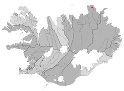
Raufarhöfn is a village located on the northeastern tip of the Melrakkaslétta peninsula in Iceland.
As of January 2011, it has 194 inhabitants. It was a major fish processing station during the large herring catches in the mid 20th century.
The village is the site of a modern monument called the "Arctic Henge" which is aligned to the heavens and is inspired by the mythical world of Eddic poem Völuspá (Prophecy of the Seeress).[3]
See also
References
- ↑ Political division
- ↑ Mainly statistical division
- ↑ "Aurora Over Raufarhöfn". APOD. NASA. 2012-04-30. Retrieved 30 April 2012.
External links
This article is issued from Wikipedia. The text is available under the Creative Commons Attribution/Share Alike; additional terms may apply for the media files.