Rano Kau

Rano Kau is a 324 m (1,063 ft) tall extinct volcano that forms the southwestern headland of Easter Island, a Chilean island in the Pacific Ocean. It was formed of basaltic lava flows in the Pleistocene with its youngest rocks dated at between 150,000 and 210,000 years ago.
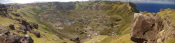
The crater
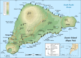
Rano Kau has a crater lake which is one of the island's only three natural bodies of fresh water. Most of the volcano is on the coast and has been eroded back to form high sea cliffs which at one point have started to bite into the crater wall. On its northern side, the volcano slopes down to Mataveri International Airport.
Rano Kau is in the world heritage site of Rapa Nui National Park and gives its name to one of the seven sections of the park. The principal archaeological site on Rano Kau is the ruined ceremonial village of Orongo which is located at the point where the sea cliff and inner crater wall converge. One ahu with several moai was recorded on the cliffs at Rano Kau in the 1880s, but had fallen to the beach by the time of the Routledge expedition in 1914.
As well as basalt, it contains several other igneous rocks including obsidian (for which it was one of the major sources for the island's stoneworkers) and pumice.
The crater is almost a mile across and has its own micro climate. Sheltered from the winds that wet most of the rest of the island, figs and vines flourish at Rano Kau.[1] The inner slope was the site of the last toromiro tree in the wild until the specimen was chopped down for firewood in 1960.
Geothermal activity
At some point in the early twentieth century, the island's manager took a photograph of steam coming out of the crater wall.[2]
See also
External links
- (Spanish) Rapa Nui National Park
- Rapa Nui National Park - UNESCO World Heritage Centre
- Guide to Easter Island from the Easter Island Foundation
References
- ↑ Flenley & Bahn 2003 The enigmas of Easter Island ISBN 0-19-280340-9 page 18
- ↑ Steam crack in Rano Kau
- Haase, Karsten M.; Peter Stoffers and C. Dieter Garbe-Schönberg (October 1997). "The Petrogenetic Evolution of Lavas from Easter Island and Neighbouring Seamounts, Near-ridge Hotspot Volcanoes in the SE Pacific". Journal of Petrology 38 (06): 785–813. doi:10.1093/petrology/38.6.785. Retrieved 2010-03-16.
- Katherine Routledge The Mystery of Easter Island (1919) ISBN 0-932813-48-8
- VAN TILBURG, Jo Anne. 1994. Easter Island: Archaeology, Ecology and Culture. Washington D.C.: Smithsonian Institution Press.
| |||||||