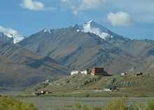
Rangdum Monastery
| Rangdum Monastery | |
|---|---|
 Rangdum Monastery seen from the north. | |
 Rangdum Monastery Location within India
| |
| Coordinates: | 34°3′36″N 76°21′0″E / 34.06000°N 76.35000°E |
| Monastery information | |
| Location | Suru Valley, Ladakh, Jammu and Kashmir, India |
| Founded by | Gelek Yashy Takpa |
| Founded | 18th century? |
| Type | Tibetan Buddhist |
| Sect | Gelug |
| No. of monks | 30 |
Rangdum Monastery is a Tibetan Buddhist monastery belonging to the Gelugpa sect, situated on top of a small but steep sugarloaf hill at an altitude of 4,031 m (13,225 ft) at the head of the Suru Valley, in Ladakh. It is next to the tiny village of Julidok, and about 25 km from the 4,400 m (14,436 ft) Pensi La (pass) which leads into Zanskar[1]
History
According to an inscription the monastery was built by Gelek Yashy Takpa during the reign of King Tsewang Mangyul of Ladakh about 200 years ago. Although it is physically in the Suru Valley, it is culturally part of Zanskar.[1] Because one cannot count on crops being harvested due to the brief summer, both the village and the monastery depend on supplies, other than locally produced dairy, brought up the largely barren Suru Valley, or over the 4,400 metre (14,436 ft) Pensi La pass from Zanskar. The monastery is home to about 30 monks and almost as many donkeys.[1][2]

Footnotes
References
- Janet Rizvi. (1996). Ladakh: Crossroads of High Asia. Second Edition. Oxford University Press, Delhi. ISBN 0-19-564546-4.
- Schettler, Margaret & Rolf (1981). Kashmir, Ladakh & Zanskar. Lonely Planet Publications. South Yarra, Victoria, Australia. ISBN 0-908086-21-0.
External links
| Part of a series on |
| Tibetan Buddhism |
|---|
 |
|
Key concepts
|
|
Key figures |
|
Practices and attainment |
|
|
|
| Wikimedia Commons has media related to Rangdum Monastery. |
Coordinates: 34°04′N 76°21′E / 34.06°N 76.35°E
| ||||||||||||||||||||