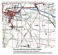
Raml Zayta
From Wikipedia, the free encyclopedia
| Raml Zayta | ||
| ||
 Raml Zayta |
||
| Arabic | رمل زيتة | |
| Also Spelled | Raml Zeita (Khirbat Qazaza) | |
| Subdistrict | Tulkarm | |
| Coordinates | 32°26′6″N 34°56′12″E / 32.43500°N 34.93667°ECoordinates: 32°26′6″N 34°56′12″E / 32.43500°N 34.93667°E | |
| Population | 140 (1945) | |
| Area | ||
| Date of depopulation | unknown[1] | |
| Cause(s) of depopulation | ||
| Current localities | Sde Yitzchaq,[2] Chadera[2] | |
Raml Zayta (Arabic: رمل زيتة, Raml Zeitâ) was a Palestinian Arab village located 15 km northwest of Tulkarm.[3] In 1945, the village had a population of 140.[4] Raml Zayta was depopulated during the 1947–1948 Civil War in Mandatory Palestine. According to Benny Morris, the causes and date of the depopulation are unknown, [5] however, he also notes that within a fortnight of a 30 March 1948 meeting "the Hagana, for strategic reasons, decided that no Arabs should remain in the Hadera area and those still there were to be expelled"[6]
However, the American historian Rosemarie Esber interviewed refugees from Raml Zaita. Zakiya Abu Hammad said that Yishuv forces besieged the village for about two weeks, causing a lack of food:"[The Jews] started going into people's homes and forcing them out. They told us, "You either leave or we´ll kill you." Some people were killed on the roads, as they abandoned their homes...They followed us. Those who were lucky, escaped with their lives, others did not."[7]
References
Bibliography
- Esber, Rosemarie M. (2008), Under the Cover of War, The Zionist Expulsions of the Palestinians. Arabicus Books & Media. ISBN 0-9815131-7-4, ISBN 978-0-9815131-7-1.
- Hadawi, Sami (1970), Village Statistics of 1945: A Classification of Land and Area ownership in Palestine, Palestine Liberation Organization Research Center
- Khalidi, Walid (1992), All That Remains: The Palestinian Villages Occupied and Depopulated by Israel in 1948, Washington D.C.: Institute for Palestine Studies, ISBN 0-88728-224-5
- Morris, Benny (2004). The Birth of the Palestinian Refugee Problem Revisited. Cambridge University Press. ISBN 978-0-521-00967-6.
See also
This article is issued from Wikipedia. The text is available under the Creative Commons Attribution/Share Alike; additional terms may apply for the media files.
