Różan
From Wikipedia, the free encyclopedia
| Różan | ||
|---|---|---|
 | ||
| ||
 Różan | ||
| Coordinates: 52°53′25″N 21°23′45″E / 52.89028°N 21.39583°ECoordinates: 52°53′25″N 21°23′45″E / 52.89028°N 21.39583°E | ||
| Country |
| |
| Voivodeship | Masovian | |
| County | Maków | |
| Gmina | Różan | |
| Town rights | 1378 | |
| Government | ||
| • Mayor | Jerzy Kazimierz Parciński | |
| Area | ||
| • Total | 6.67 km2 (2.58 sq mi) | |
| Population (2006) | ||
| • Total | 2,661 | |
| • Density | 400/km2 (1,000/sq mi) | |
| Time zone | CET (UTC+1) | |
| • Summer (DST) | CEST (UTC+2) | |
| Postal code | 06-230 | |
| Area code(s) | +48 29 | |
| Car plates | WMA | |
| Website | www.rozan.eur.pl | |

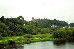
Różan [ˈruʐan] is a town in Mazovian Voivodeship, Poland, on the river Narew. National roads 60 and 61 intersect in the town.
The crossing of the Narew at Różan had significant military importance in the first half of the 20th century. The Russian Imperial Army fortified and garrisoned Różan around 1900. It was defended against German attacks in 1915 in the course of World War I. Fortified further before 1939, it was defended by the Polish army in the course of the German Invasion of Poland in September, 1939. Then, in the course of the fighting in 1944, the Red Army seized a bridgehead across the Narew at Różan, which it used as one of the springboards for the January 1945 Vistula–Oder Offensive.
| Wikimedia Commons has media related to Różan. |
External links
- Jewish Community in Różan on Virtual Shtetl
- 1:25,000 topographic map from 1941
| ||||||||||
This article is issued from Wikipedia. The text is available under the Creative Commons Attribution/Share Alike; additional terms may apply for the media files.