Quito Canton
| Quito | |||
|---|---|---|---|
| Canton | |||
| Metropolitan District of Quito | |||
| |||
 | |||
 | |||
| Country | Ecuador | ||
| Province | Pichincha | ||
| Named for | Quitu | ||
| Seat | Quito | ||
| Government | |||
| • Mayor | Augusto Barrera | ||
| Area | |||
| • Total | 4,204 km2 (1,623 sq mi) | ||
| Highest elevation | 4,500 m (14,800 ft) | ||
| Lowest elevation | 2,400 m (7,900 ft) | ||
| Population (2001 Census) | |||
| • Total | 1,839,853 | ||
| • Density | 440/km2 (1,100/sq mi) | ||
| Time zone | ECT (UTC-5) | ||
| Website | http://www.quito.gov.ec/ | ||
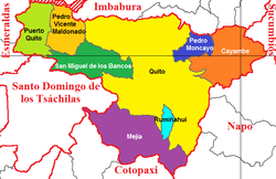
Quito, officially the Metropolitan District of Quito (Spanish: Distrito Metropolitano de Quito), is a canton in the province of Pichincha, Ecuador.
Governance
The canton is governed by the same mayor and city council that govern the city of Quito.

Population figures
According to the 2001 census, the total population of Quito (not the city itself) is 1,839,853, with 892,570 men and 947,283 women. According to the 2007 estimates, it is 1,840,000. Of this, the population of the urban parishes (the city of Quito itself) was 1,399,378, and the population of the rural parishes (outside of the city of Quito, but still within the canton) was 440,475.[1] The total population density of the canton is 439.8 inhabitants per km² (1139.1/mi²). The total number of households in the cantón is 555,928, with 419,845 in the urban area (= city) and 136,083 in the rural area.[2] Of the 1,407,526 inhabitants of the canton over the age of 12, 639,068 are married, 541,758 are single, 33,116 are divorced, 30,898 are separated, and 47,930 are widowed.[3]
Overall, the canton's illiteracy rate is 4.3% – 5.3% for women, 3.2% for men, 3.6% in the urban area (= city), and 6.6% in the rural area.[4] The unemployment rate of the city is 8.9%, and 43.8% are underemployed.[5] The average monthly income is $317.[6]

Political divisions
The canton is divided into 55 parishes (Spanish: parroquias), classified as either urban or rural. The canton has more parishes than any other canton in Ecuador. The urban parishes make up the city of Quito. (map):
|
Rural parishes
|
Urban parishes
|

Administrative zones
The canton is divided in 11 administrative zones that decentralize the municipality and participate in system of active management. Each zone, classified as either urban or suburban, has their own administrator and contain can both urban and rural parishes. They are (parishes covered in parenthesis):
|
Urban
|
Suburban
|
Hotel Plaza Grande is located in the Plaza de la Independencia,
 Historic Center of Quito

References
- ↑ http://www.inec.gov.ec/interna.asp?inc=cs_tabla&idTabla=82&tipo=p&idProvincia=17&idSeccion=&idCiudad=51
- ↑ http://www.inec.gov.ec/interna.asp?inc=cs_tabla&idTabla=89&tipo=p&idProvincia=17&idSeccion=&idCiudad=51
- ↑ http://www.inec.gov.ec/interna.asp?inc=cs_tabla&idTabla=88&tipo=p&idProvincia=17&idSeccion=&idCiudad=51
- ↑ http://www.inec.gov.ec/interna.asp?inc=cs_grafico&idGrafico=1005&tipo=p&idProvincia=17&idSeccion=&idCiudad=51
- ↑ http://www.inec.gov.ec/interna.asp?inc=enc_tabla&idTabla=295
- ↑ http://www.inec.gov.ec/interna.asp?inc=enc_tabla&idTabla=299
| |||||||
Coordinates: 0°13′S 78°31′W / 0.217°S 78.517°W


