Quebec Route 371
From Wikipedia, the free encyclopedia
| ||||
|---|---|---|---|---|
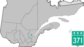 | ||||
| Route information | ||||
| Maintained by Transports Québec | ||||
| Length: | 1.0 km[1] (0.6 mi) | |||
| Major junctions | ||||
| North end: |
| |||
|
| ||||
| South end: |
| |||
| Location | ||||
| Major cities: | Quebec City, Stoneham | |||
| Highway system | ||||
| ||||

Towns along Route 371
- Quebec City including L'Ancienne-Lorette and Loretteville
- Val-Bélair
- Valcartier
- Saint-Gabriel-de-Valcartier
- Stoneham-et-Tewkesbury
See also
References
- ↑ Ministère des transports, "Distances routières", page (?), Les Publications du Québec, 2005
External links
- Official Transports Quebec Road Map Network (French)
- Route 371 on Google Maps
This article is issued from Wikipedia. The text is available under the Creative Commons Attribution/Share Alike; additional terms may apply for the media files.